
Wandelgids Ayrshire & Arran Coastal Paths - Cicerone
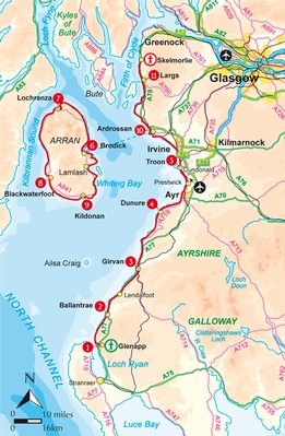
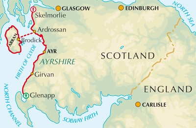
145km van Glenapp in het zuiden tot Skelmorlie in het noorden
Korte omschrijving
Wandelgids - Ayrshire & Arran Coastal Paths - Cicerone Productomschrijving: Deze handige gids bevat routebeschrijvingen voor 11 dagfasen over een 150 mijl lange kustlijn, vol met prachtige z...

Specificaties
- Uitgever: CICERONE Press
- ISBN-13: 9781852846329
- HOOFDCATEGORIEËN: Wandelgids
- Activiteiten: Wandelen, Hiking & Trekking
- Regio: Ayrshire Lanark, West Schotland
- Land: Schotland
- Blz.: 176
- Afmeting: 12x17
- Editie: 1
- Taal: Engels
Volledige omschrijving
Wandelgids - Ayrshire & Arran Coastal Paths - Cicerone
Productomschrijving: Deze handige gids bevat routebeschrijvingen voor 11 dagfasen over een 150 mijl lange kustlijn, vol met prachtige zandstranden en afgelegen baaien. Het terrein varieert van strand tot open veenland en rotsachtige paden, maar is geschikt voor een redelijk fitte wandelaar. De Ayrshire and Arran kustpaden, bieden de mooiste lange afstand kustpaden. De fantastische Ayrshire Coastal Path biedt zijn route voor 94 mijl, van Glenapp in het zuiden tot Skelmorlie in het noorden. Voeg dit toe aan de Arran Coastal Path, die zich rond dat magische eiland voor 60 mijl begeeft, en wat men krijgt, is echt een prachtige lange afstand pad.
Product description: This handy guidebook contains route descriptions for 11 day stages across a 150 mile coastline full of beautiful sandy beaches and secluded coves. The terrain varies from beach to open moorland and rocky trails but is suitable for any reasonably fit walker. The Ayrshire and Arran Coastal Paths offers long distance coastal walking at its finest. The fantastic Ayrshire Coastal Path strikes its course for 94 miles from Glenapp in the south to Skelmorlie in the north. Add this to the Arran Coastal Path, which circumnavigates its way round that magical island for 60 miles, and what you have is truly magnificent long distance coastal walk.
Seasons:
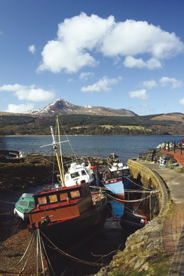
Spring and summer are the best time to walk the route for longer daylight hours and best opportunities to spot flowers and wildlife.Centres CentresGirvan, Ayr, Irvine, Troon, Ardrossan, Brodick, Whiting Bay, Lamlash, Largs, Skelmorlie.
Difficulty:
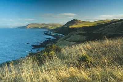
No technical rock climbing ability required but some sections require a little scrambling over boulders on beaches; a good level of fitness needed to tackle the route in one go and some navigational skills in poorer weather as some of the route is quite remote.
Must See:
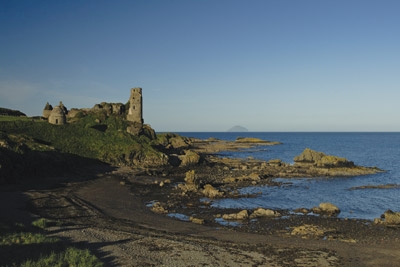
Freat cliffs, beautiful sandy beaches and secluded coves; extraordinary buildings such as Culzean Castle, Turnberry Lighthouse, Lochranza Castle and the Kennedy Mausoleum; historically important geological sites and several places indelibly linked to Robert Burns and Robert the Bruce.
Locatie op kaart
Artikelen uit dezelfde regio

Wandelkaart 318 Galloway Forest Park North Ayrshire - OSI • 9780319245705
Wandelkaart Galloway Forest Park North - Ayrshire Schotland Productbeschrijving: Glen Trool & Loch Doon St John’s Town of Dalry. 318 / Galloway Forest Park North, Ayrshire, Schotland - OS Explorer kaart 318 toont het noordelijk deel van het Fallowway Forest Park, Doon Loch, Loch Trool, de Southern Upland Way en de E2 Europese Long Distance pad. De OS Explorer kaart voor Galloway Fores…

Wandelkaart 327 Cumnock & Dalmellington - OSI • 9780319471999
Wandelkaart Cumnock & Dalmellington - Ayrshire Schotland Omvat ook: Mauchline & Patna. Productbeschrijving: OS Explorer 327 omvat Cumnock en het omliggende gebied. Hoogtepunten zijn delen van de Galloway Forest Park, de rivier Ayr en de heuvels rond Dalmellington en Loch Doon, die op zich al een mooie wandeling beloofd. De OS Explorer kaart voor Cumnock & Dalmellington is beschikbaar i…

Wandelkaart XT40 Arran ultra - Harvey Maps • 9781851375882
Wandelkaart XT40 - Arran ultra - Harvey Maps Productomschrijving: Arran is een Brits eiland in het westen van Schotland. Het behoort tot het raadsgebied (council area) North Ayrshire. Arran wordt ook wel Schotland in het klein genoemd. Het eiland ligt in de Firth of Clyde. De belangrijkste plaats op Arran is Brodick (een oude Noorse naam voor brede baai). Brodick is de plaats waar de veerb…

Wandelkaart 361 Isle of Arran - OSI • 9780319475775
Wandelkaart Isle of Arran - OSI Productbeschrijving: Arran is het grootste eiland in de Firth of Clyde, bergachtig, met de hoogste piek "Goat Fell", permanent op 874m. Arran word geacht alle verschillende typen landschappen in Schotland te vertegenwoordigen, van de ruige kust vlakten en grillige pieken, waardoor het een populaire bestemming is geworden. De OS Explorer kaart voor Isle van A…

Wandelkaart 372 Coll & Tiree- Ayrshire & Lanark - OSI • 9780319246191
Wandelkaart Coll & Tiree - Ayrshire & Lanark West Schotland Productbeschrijving: 372 / Coll & Tiree, Ayrshire & Lanark, West Schotland - Kaart nummer 372 omvat Coll en Tiree. Hoogtepunten zijn Calgary punt, Gunna, Gott Bay, Crossapol Bay en Hynish Bay. Omvat ook Loch Fada en Loch Cilad. De OS Explorer kaart voor Coll & Tiree is beschikbaar in zowel de standaard papieren versie als de w…