
Wandelgids North Downs Way - Map Booklet - Cicerone
208 km over de North Downs Way - tussen Farnham en Dover
Korte omschrijving
Wandelgids - North Downs Way - Map Booklet - Cicerone Productomschrijving: Kaart van de 208km, over de North Downs Way National Trail, tussen Farnham en Dover, met inbegrip van een optioneel...

Specificaties
- Uitgever: CICERONE Press
- ISBN-13: 9781852849559
- HOOFDCATEGORIEËN: Wandelkaart
- Activiteiten: Wandelen, Hiking & Trekking
- Auteur: Kevin Renolds
- Regio: Dover, England, Farnham, Engeland, Kent South East England, South & South East England, Surrey South England
- Land: England
- Lange afstand wandelroutes: North Downs Way (246 km)
- AONB - Area of Outstanding Beauty: Kent Downs AONB, Surrey Hills AONB
- Blz.: 96
- Schaal: 1:25000
- Afmeting: 12x17
- Editie: 1
- Taal: Engels
Volledige omschrijving
Wandelgids - North Downs Way - Map Booklet - Cicerone
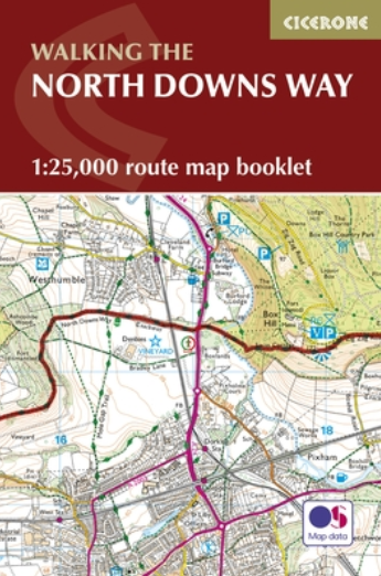
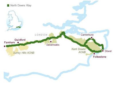
Productomschrijving: Kaart van de 208km, over de North Downs Way National Trail, tussen Farnham en Dover, met inbegrip van een optioneel bezoek aan Canterbury. Dit boekje is opgenomen in de Cicerone gids en toont het volledige parcours op OS 1: 25.000 kaarten. Een van de eenvoudigere nationale routes, dat comfortabel kan worden gelopen in 11-12 dagen.
Product decription: Map of the 130 mile (208km) North Downs Way National Trail, between Farnham and Dover, including an optional visit to Canterbury. This booklet is included with the Cicerone guidebook to the trail and shows the full route on OS 1:25,000 maps. One of the easier National Trails, it can be comfortably walked in 11-12 days.
Seasons:
The North Downs Way can be walked at any time of the year, but is seen at its best between April and October.
Centres:
Beginning in Farnham, the North Downs Way passes close to or through Guildford, Otford, Wrotham, Detling, Charing, Wye, Chilham, Canterbury and Patrixbourne and ends in Dover.
Difficulty:
Despite some reasonably short steep ascents and descents, the North Downs Way is one of the more gentle of National Trails and is suitable for first-time long-distance walkers.
Must See:
Passing through the Surrey and Kent Downs Areas of Outstanding Natural Beauty, the North Downs Way crosses Box Hill, visits Neolithic sites like the Coldrum Stones and Kits Coty House, passes below the remains of Thurnham Castle, visits Canterbury Cathedral and Dover Castle, and wanders across Shakespeare Cliff, one of the White Cliffs of Dover.

Locatie op kaart
Overzichtskaarten

Area's of Outstanding Natural Beauty - AONB's UK
Area's of Outstanding Natural Beauty - AONB's UK

Producten op de overzichtskaart
Klik op een product om naar de detailpagina te gaan.
- Wandelgids - Guide to the Cotswolds AONB - AA
- Wandelkaart 24 - Chilterns AONB - AA
- Fietskaart- en Mtb kaart - The Cotswolds - Goldeneye
- Wandelgids - Cotswold classic walks guidebook - Goldeneye
- Wandelkaart - Cotswold South AONB - Goldeneye
- Wandelgids - Exploring the Cotswolds - Goldeneye
- Wandelgids - Cotswold Classic Walks - Goldeneye
- Wandelkaart - Cotswolds- Malverns & Forest of Dean - Goldeneye
- Wandelgids - The Cotswold Way 30 classic routes - Cicerone
- Wandelgids - Kent walking guide - Cicerone
- Wandelgids - North Downs Way Nat. trail - Cicerone
- Wandelgids - Chilterns walking guide - Cicerone
- Wandelgids - Suffolk coast & Heaths walks - Cicerone
- Wandelgids - North Downs Way - Map Booklet - Cicerone
- Wandelgids - North Pennines AONB walking guide - Cicerone
- Wandelgids - Ridgeway National Trail - Cicerone
- Wandelgids - Forest of Bowland & Pendle - Cicerone
- Wandelgids - Hampshire's Test Way walking guide - Cicerone
- Wandelgids & Fietsgids - The Cotswold AONB - Cicerone
- Wandelgids - Walking on the Gower - Cicerone
- Wandelgids - North Wessex Downs - Cicerone Press
- Wandelgids - Walking on the North Wessex Downs - Cicerone
- Wandelgids - Silverdale & Arnside AONB - Cicerone
- Wandelgids - The Kennet and Avon Canal walking guide - Cicerone
- Wandelgids - North Downs Way- 246 km - Trailblazer
- Wandelkaart OL2 - Yorkshire Dales- Southern & Western Areas - OSI
- Wandelkaart OL19 - Howgill Fells and Upper Eden Valley - OSI
- Wandelkaart OL21 - South Pennines - Yorkshire - OSI
- Wandelkaart OL31 - North Pennines- Teesdale & Weardale - OSI
- Wandelkaart OL40 - The Broads - OSI
- Wandelkaart OL41 - Forest of Bowland & Ribblesdale - OSI
- Wandelkaart OL45 - The Cotswolds AONB- Gloucestershire - OSI
- Wandelkaart 108 - Lower Tamer Valley & Plymouth- Cornwall- OSI
- Wandelkaart 115 - Exmouth & Sidmouth- Devon - OSI
- Wandelkaart 137 - Ashford- Kent downs AONB- England - OSI
- Wandelkaart 140 - Quantock Hills AONB- Somerset - OSI
- Wandelkaart 140 - Quantock Hills AONB & Bridgwater- Devon - OSI
- Wandelkaart 147 - Sevenoaks & Tonbridge- Kent - OSI
- Wandelkaart 164 - Gower AONB & Gwyr- South Wales - OSI
- Wandelkaart 164 - Gower AONB & Gwyr- Wales - OSI
- Wandelkaart 171 - Chiltern Hills West & Henley-on-Thames OSI
- Wandelkaart 171 - Chiltern Hills West AONB- Wycombe - OSI
- Wandelkaart 172 - Chiltern Hills East AONB- Wycombe - OSI
- Wandelkaart 181 - Chiltern Hills AONB North- England - OSI
- Wandelkaart 181 - Chiltern Hills North AONB- Wycombe - OSI
- Wandelkaart 190 - Malvern Hills & Bredon Hill - OSI
- Wandelkaart 190 - Malvern Hills AONB & Bredon Hill - OSI
- Wandelkaart 203 - Ludlow- Shropshire Hills AONB - OSI
- Wandelkaart 217 - Long Mynd & Wenlock Edge- Schropshire- OSI
- Wandelkaart 254 - Lleyn Peninsular East- North Wales - OSI
- Wandelkaart 261 - Boston- Lincolnshire AONB - OSI
- Wandelkaart 262 - Anglesey West- Wales AONB - OSI
- Wandelkaart 263 - Anglesey East AONB- Wales - OSI
- Wandelkaart 273 - Lincolnshire Wolds South AONB - OSI
- Wandelkaart 282 - Lincolnshire Wolds North AONB - OSI
- Wandelkaart 298 - Nidderdale AONB- Yorkshire - OSI
- Wandelkaart 298 - Nidderdale AONB North Yorkshire - OSI
- Wandelkaart 300 - Howardian Hills AONB - OSI
- Wandelkaart 300 - Howardian Hills AONB & Malton - OSI
- Wandelkaart - Mourne Mountains N. Ireland - Harvey maps
- Wandelkaart - Fietskaart Forest of Bowland - Harvey maps
- Wandelkaart XT40 - Anglesey Coastal Path N. Wales - Harvey Maps
- Wandelkaart XT40 - Pennine Way Noord - Harvey Maps
- Wandelkaart XT40 - Pennine Way Zuid - Harvey Maps
- Wandelgids Cotswold - Way Two-way trekking guide - Knife Edge
- Reisgids Oxford & the Cotswolds AONB - Edicola
- Reisgids Cotswolds England - Rough Guides
- Reisgids Go Slow- Sussex & the South Downs- Weald & Coast - Bradt
- Travelguide Oxford & The Cotswolds pocket guide - Lonely Planet
- Wandelgids - The Ridgeway National trail - Trailblazer
Artikelen uit dezelfde regio

Wandelkaart 179 Canterbury & East Kent - England - OSI • 9780319262771
Wandelkaart Canterbury & East Kent - SE England Productbeschrijving: Landranger kaart nummer 179 toont de Zuid-Oostelijke kust van Engeland, waaronder de kathedraal stad Canterbury, de havens van Felixstowe en Dover, evenals Margate, Hythe, Whitstable en Herne Bay. De OS Landranger kaarten reeks heeft betrekking op Groot-Brittannië met 204 gedetailleerde kaarten, perfect voor dagtochten en…

Wandelkaart 145 Guildford & Farnham- Surrey - OSI • 9780319243381
Wandelkaart Guildford & Farnham- Surrey England Productbeschrijving: Guildford & Farnham- Surrey zijn plaatsen in het bestuurlijke gebied Guildford, in het Engelse graafschap Surrey. 145 / Guildford & Farnham, Surrey, England - Kaart nummer 145 is een all purpose kaart vol gepakt met informatie om u het gebied te helpen leren kennen. De 204 Landranger-kaarten bestrijken het land. Elke …

Wandelkaart OL22 New Forest- Southampton & Ringwood - OSI • 9780319475782
Wandelkaart New Forest national park - Southampton - OSI Productomschrijving: Kaart nummer OL22 in de OS Explorer kaartenserie is de perfecte kaart voor vakantiegangers en dagjesmensen om te gebruiken bij een bezoek aan het New Forest Nationaal Park in West Engeland. Het nationale park is beroemd om zijn uitstekende wandelingen en ritten en is de thuisbasis van New Forest pony's en heidela…

Wandelkaart 137 Ashford Kent downs AONB England - OSI • 9780319470091
Wandelkaart Ashford - Kent downs AONB England - OSI Productbeschrijving: Kaart nummer 137 in de OS Explorer-serie dekt de volledige omgeving van Kent in de buurt van Ashford en de Kent Downs, een Area of Outstanding Natural Beauty AONB. De North Downs Way National Trail gaat langs de steden van Wye en Chilham, terwijl de Stour Valley Walk langs de Great Stour loopt. Andere hoogtepunten va…

Wandelkaart 188 Maidstone & Royal Tunbridge Wells - OSI • 9780319475119
Wandelkaart Maidstone & Royal Tunbridge Wells - Kent England Productbeschrijving: OS Landranger kaart 188 omvat Maidstone, gelegen aan de oevers van de rivier de Medway, en de hoofdplaats van Kent met het mooie platteland voor de deur. Een deel van de E2 Europese Long Distance pad ligt in het noorden en de historische kuuroord stad van Royal Tunbridge Wells naar het zuiden. De OS Landr…