
Wandelgids The Pennine Way - Cicerone
320 km van Edale naar Kirk Yetholm duurt drie weken
Korte omschrijving
Wandelgids - The Pennine Way - Cicerone Productomschrijving: De Pennine Way National Trail met OS kaart boekje. De route van de 320 km van Edale naar Kirk Yetholm duurt drie weken om te lope...

Specificaties
- Uitgever: CICERONE Press
- ISBN-13: 9781852849061
- HOOFDCATEGORIEËN: Wandelgids
- Activiteiten: Wandelen, Hiking & Trekking
- Auteur: Paddy Dylan
- Regio: Derbyshire, England, North & North East England
- Land: England
- Lange afstand wandelroutes: Pennine Way (420 km)
- Nationale parken: Peak District NP, Derbyshire UK
- Blz.: 240
- Afmeting: 12x17
- Editie: 4
- Taal: Engels
Volledige omschrijving
Wandelgids - The Pennine Way - Cicerone
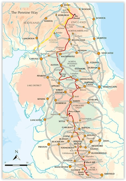
Productomschrijving: De Pennine Way National Trail met OS kaart boekje. De route van de 320 km van Edale naar Kirk Yetholm duurt drie weken om te lopen en is geschikt voor fit en langeafstand ervaren wandelaars. De route doorkruist het Peak District NP, de Yorkshire Dales NP en de North Pennines nationale parken. Bevat afzonderlijk boekje van de route.
Productdescription: Guidebook to the Pennine Way National Trail with OS map booklet. The 270 mile route from Edale to Kirk Yetholm takes three weeks to walk and is suitable for fit and experienced long distance walkers. The route crosses the Peak District, Yorkshire Dales and North Pennines National Parks. Includes separate OS 1:25,000 map booklet of the route.
Seasons:
This National Trail is essentially a summer walk, though it can be completed in spring or autumn, the winter months are solely for dedicated and experienced long-distance walkers.
Centres:
Edale, Crowden, Hebden Bridge, Cowling, Gargrave, Malham, Horton in Ribblesdale, Hawes, Keld, Bowes, Middleton-in-Teesdale, Dufton, Alston, Hadrian's Wall, Bellingham, Byrness, Kirk Yetholm.
Difficulty:
The Pennine Way is a challenging walk, often across high, exposed moorlands. No problems on fine, sunny days, but some parts can be exceptionally difficult in bad weather. In mist, careful navigation is required, but on the whole the route is well-signposted. Suitable for backpackers and youth hostellers, but ample B&B accommodation is also available. Previous long-distance walking experience is an advantage.
Must See:
Peak District National Park - Kinder Scout, Bleaklow and Black Hill; South Pennines - Stoodley Pike and Brontë Country; Yorkshire Dales National Park - Malham Cove, Pen-y-Ghent and Great Shunner Fell; North Pennines AONB - Teesdale, High Cup and Cross Fell; Northumberland National Park - Hadrian's Wall and the Cheviot Hills.
Locatie op kaart
Artikelen uit dezelfde regio

Wandelgids The Coast to Coast Map Booklet - Cicerone • 9781852849269
Wandelgids - The Coast to Coast Map Booklet - Cicerone Productomschrijving: Deze wandelgids toont u de 300km lange Coast to Coast Walk, een populaire interlokale trail in Noord-Engeland, die vertrekt uit St Bees Head in Cumbria naar Robin Hood's Bay aan de kust van Yorkshire. Product description: This map booklet shows the 190 mile (300km) Coast to Coast Walk, a popular long distance …

Wandelkaart 269 Chesterfield & Alfreton- Derbyshire - OSI • 9780319471418
Wandelkaart Chesterfield & Alfreton - Derbyshire East Midlands Omvat ook: Sutton in Ashfield & Bolsover. Productbeschrijving: OS Explorer kaart 269 omvat Chesterfield, Sutton in Ashfield en Alfreton. Er vallen een aantal parken om te ontdekken, evenals deel van de Trans Pennine Trail. De Five Pits Trail in Grassmoor is open voor fietsers, wandelaars en ruiters. De OS Explorer kaart voo…

Fietsgids Peak District cycling - Cicerone • 9781852848781
Fietsgids - Peak District cycling - Cicerone Productomschrijving: Fietsgids over het Peak district, die routes beschrijft in- en rond het National Park, op de weg of op de talrijke fietsroutes. 20 dag routes en één meerdaags fietsroute door het Peak District. Allemaal gemakkelijk toegankelijke routes vanuit Sheffield en Manchester, met routes vanaf het charmante Derbyshire, met steden zoal…

Wandelkaart Cleveland Way - Across North York NP - Harvey maps • 9781851374892
Wandelkaart Cleveland Way - Across North York NP - Harvey maps Productomschrijving: 174km (109 mijl) van Helmsley over het North York Moors National Park naar Saltburn en langs de kust via Scarborough eindigend met Filey. Informatie over het vinden van accommodatie, camping, voedsel. Routebeschrijving naar het begin. Ook Ranger Service contacten met nummers en uitbreidingen van steden/dorp…

Wandelkaart 119 Buxton & Matlock Derbyshire - OSI • 9780319262177
Wandelkaart Buxton & Matlock - Derbyshire England - OSI Productbeschrijving: Kaart nummer 119 in de OS Landranger kaarten serie is de ideale kaart voor het plannen van dagexcusries rond het gebied Buxton en Matlock. In het hart van het Peak District heeft dit gebied veel te bieden voor de hele familie. Wandelingen in het pittoreske platteland, spa breaks, shopping trips en de kunsten zijn …