
Wandelgids South West Coast Path North - Cicerone
Deel 1 wandelpad van Minehead tot St-Yves
Korte omschrijving
Wandelgids - South West Coast Path North - Cicerone Productomschrijving: Een eerste deel van het 1014km lange wandelpad die in deze gids loopt van Minehead tot St-Yves. Detail Uitgever: ...

Specificaties
- Uitgever: CICERONE Press
- ISBN-13: 9781852849368
- HOOFDCATEGORIEËN: Wandelgids
- Activiteiten: Wandelen, Hiking & Trekking
- Regio: South West England
- Land: England
- Lange afstand wandelroutes: South West Coast Path - SWCP (1014 km)
- Blz.: 112
- Schaal: 1:25000
- Afmeting: 12x17
- Editie: 1
- Taal: Engels
Volledige omschrijving
Wandelgids - South West Coast Path North - Cicerone
Productomschrijving: Een eerste deel van het 1014km lange wandelpad die in deze gids loopt van Minehead tot St-Yves.
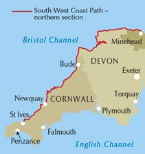
Detail Uitgever: The South West Coast Path is Britain's longest National Trail, stretching some 630 miles (1014km) between Minehead in Somerset and Poole in Dorset. It takes in a National Park, 5 Areas of Outstanding Natural Beauty, National Heritage Coasts and a UNESCO World Heritage Site.
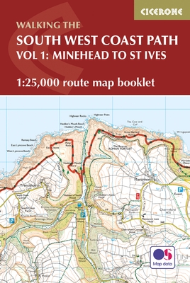
Product description: This booklet of Ordnance Survey 1:25,000 Explorer maps has been designed for convenient use on the trail, covering the northern part of the route between Minehead and St Ives. It shows the full and up-to-date line of the National Trail, along with the relevant extract from the OS Explorer map legend. It is conveniently sized for slipping into a jacket pocket or top of a rucksack and comes in a clear PVC sleeve. Two separate booklets cover the rest of the route, from St Ives to Plymouth and from Plymouth to Poole.
Seasons:
This National Trail may be walked year-round: be aware that winter accommodation availability may be limited, while high summer will be extremely busy and the weather often hot.
Centres:
Many centres are passed along the route, including Minehead, Lynmouth, Westward Ho!, Clovelly, Bude, Padstow, Newquay, St Ives.
Difficulty:
The South West Coast path is a long walk! Most paths are easy to moderate, with some walks along rugged and exposed coastal cliff paths and some steep gradients.
Must See:
Exmoor National Park, Areas of Outstanding Natural Beauty, numerous Heritage Coasts, National and Local Nature Reserves, Sites of Special Scientific Interest and National Trust holdings.
.png)
Locatie op kaart
Gekoppelde artikelen

Wandelgids The South West Coast Path - Cicerone Press • 9781786310682
standaard versieThe South West Coast Path - Cicerone Productomschrijving: Omvat spectaculaire plaatsen die dit deel van het Engelse landschap rijk is, zoals Exmoor National Park, met 5 AONB's of Areas of Outstanding Natural Beauty, de Jurassic Coast Natural World Heritage Site. Deze route bestaat al heel lang. De route start of eindigd natuurlijk in Minehead, in Somerset, loopt langs de kust richting de v…

Wandelgids South West Coast Path - Cicerone • 9781852849375
standaard versieWandelgids - South West Coast Path - Cicerone Productomschrijving: DEEL 2 - Dit deel betref het zuidelijke deel van de South west Coast path in Devon England - St-Ives to Plymouth Product description: The South West Coast Path is Britain's longest National Trail, stretching some 630 miles (1014km) between Minehead in Somerset and Poole in Dorset. It takes in a National Park, 5 Areas of…

Wandelgids South West Coast Path - Cicerone • 9781786312006
standaard versieMap booklet South West Coast Path - Cicerone Productomschrijving: Kaart van een deel van het zuidelijke deel van het 630 mijl (1014 km) lange South West Coast Path National Trail. Omvat het pad van Plymouth naar Poole langs de kustlijn van Devon en Dorset. Dit handige en compacte boekje met Ordnance Survey 1:25.000 kaarten toont de route en biedt alle kaarten die je nodig hebt om het pad i…
Artikelen uit dezelfde regio

Wandelkaart South West Coast Path 5 - Harvey maps • 9781851374427
Wandelkaart - South West Coast Path 5 - Harvey maps Productomschrijving: Waterdichte XT40 kaart van Harvey. Een ideale kaart voor wandelaars op de langste en op één van haar meest populairste nationale routes. Het loopt langs de kust van Somerset, Cornwall en Devon, Dorset van Minehead round via Land's end naar Poole. Het omvat alle 95 mijls van het World Heritage site bekend als de Jurass…

Wandelgids Great Walks on the England Coast Path - Cicerone • 9781852849894
Great Walks on the England Coast Path - Cicerone Engelse omschrijving: At around 4500 km (2800 miles), the England Coast Path is the longest coastal trail in the world. This inspirational large-format guide presents a handpicked selection of 30 highlight sections, offering a taste of England's stunning and diverse shoreline. Routes range from 9 to 45km, spanning between 3 hours and 2 days,…

Wandelkaart 172 Bristol- Bath & Thornbury- S.W. England - OSI • 9780319474952
Wandelkaart Bristol- Bath & Thornbury - South West England Productbeschrijving: OS Landranger kaart 172 toont Bristol, de rivier de Avon, de Georgische stad Bath en de zuidkant van de Cotswolds way. De Roman Baths in Bad zijn het hoogtepunt van de stad, maar niet missen sommige van de uitgebreide architectuur - er zijn dat diverse voorgesteld wandeltochten die wijzen op de beste. De OS…

Wandelkaart 195 Bournemouth & Purbeck - OSI • 9780319475188
Wandelkaart Bournemouth & Purbeck - S.W. England Productbeschrijving: Kaart nummer 195 in de OS Landranger kaart reeks heeft betrekking op de kust van Dorset, Bournemouth, Poole Bay, Poole Harbour, Isle van Purbeck, de Purbeck Hills, Swanage, Christchurch Bay, Ringwood, Wimborne Minster, New Milton, Milford on Sea, Wareham en Corfe Castle. Ook inbegrepen is de meeste oostelijke gedeelte va…

Reisgids Bath- Bristol & the S.W. pocket guide - Lonely Planet • 9781787016927
Bath & Bristol & the S.W. pocket guide - Lonely Planet Covers: Bath, Bristol, Wiltshire & Somerset Product description: Lonely Planet's Pocket Bath, Bristol & the Southwest is your passport to the most relevant, up-to-date advice on what to see and skip, and what hidden discoveries await you. Take in the beautiful views from Bath's majestic Royal Crescent, go on a street art and music …