
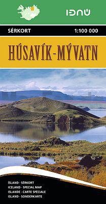
Wandelkaart 1 - Husavik & Myvatn - Ferdakort
Wat hier niet allemaal te ontdekken valt vergeet u nooit meer
Korte omschrijving
Wandelkaart 1 - Husavik & Myvatn - Ferdakort Productomschrijving: Deze serie topografische kaarten van IJsland zijn goed gedetailleerd. Alle topografische details zijn erop terug te vinden. ...

Specificaties
- Uitgever: Idnu Bokautgafa (Ferdakort)
- ISBN-13: 9789979674092
- HOOFDCATEGORIEËN: Wandelkaart
- Activiteiten: Wandelen, Hiking & Trekking
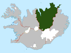
- Regio: Norðurland eystra, IJsland
- Land: Ijsland
- Schaal: 1:100000
- Afmeting: 13x22
- Editie: 1
- Taal: Engels
Volledige omschrijving
Wandelkaart 1 - Husavik & Myvatn - Ferdakort
Productomschrijving: Deze serie topografische kaarten van IJsland zijn goed gedetailleerd. Alle topografische details zijn erop terug te vinden.
This is one of the maps in the topographic survey of Iceland with the scale 1:100,000. The series was last revised in the early eighties. Contour interval is 20 meters. In addition to the usual features shown on survey mapping, the maps also include a large amount of information indicating the type of the terrain and land use (block or smooth surfaced lava, clay, boulders, sand and dunes, cultivated area, meadows, pastures, bogs, wetlands, etc.) and details not often found on maps: physicians' residences, parsonages, etc. Each map covers an area of 44 x 40 km / 27 x 25 miles. Margin ticks give latitude and longitude in steps of 6'. Map legend includes English.