
Wandelkaart 268 Lassen Volcanic NP - California - Nat Geo
Met zijn Lassen Peak- een 3181 meter hoge kegelvulkaan
Korte omschrijving
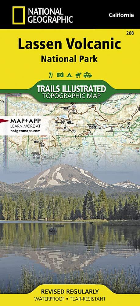
TOPO Wandelkaart 268 - Lassen Volcanic NP - Nat Geo Productomschrijving: Het Lassen Volcanic National Park is een Amerikaans nationaal park in het noordoosten van de staat Californië. Het m...

Specificaties
- Uitgever: National Geographic
- ISBN-13: 9781566956796
- HOOFDCATEGORIEËN: Wandelkaart
- Activiteiten: Wandelen, Hiking & Trekking
- Regio: Californië, USA
- Land: Verenigde Staten van Amerika (USA)
- Nationale parken: Lassen Volcanic NP, California USA
- Schaal: 1:50000
- Afmeting: 10x19, 11x24
- Taal: Engels
Volledige omschrijving
TOPO Wandelkaart 268 - Lassen Volcanic NP - Nat Geo
Productomschrijving: Het Lassen Volcanic National Park is een Amerikaans nationaal park in het noordoosten van de staat Californië. Het meest in het oog springende kenmerk in het park is de Lassen Peak, een 3181 meter hoge kegelvulkaan en de meest zuidelijke vulkaan in het Cascadegebergte.
Engelse omschrijving: Lassen Volcanic National Park in northern California is one of the few places in the world where one can see all four types of volcano. National Geographic's Trails Illustrated map of this unusual park offers outdoors enthusiasts a valuable tool for exploring the park's fumaroles, hot springs, mud pots, mountain lakes, and forests. Expertly researched and created in partnership with local land management agencies, this map features trail networks in Lassen Volcanic National Park and the adjacent national forests along with key points of interest including Lassen Peak; the Lassen Volcanic and Caribou wilderness areas; Cinder Cone; Juniper, Snag, and Butte lakes; and the Volcanic Legacy Scenic Byway. The print version of the map includes a detailed inset of the Manzanita Lake area.
Over 150 miles of trails including 17 miles of the Pacific Crest Trail and a portion of the California National Historic Trail are clearly marked and include approximate mileage between intersections and trail use designations. A chart of campgrounds, their elevations, the number of sites, and the facilities available at each will help you choose the one that's right for you. Interpretive information regarding the area's unique geology and descriptions of the important hydrothermal areas are also included. The map base shows contour lines and elevations for summits, passes and many lakes. A variety of recreation features are noted as well, including campgrounds, trailheads, picnic areas, boat launches, cabins, and scenic viewpoints. Every Trails Illustrated map is printed on "Backcountry Tough" waterproof, tear-resistant paper. A full UTM grid is printed on the map to aid with GPS navigation.
Other features found on this map include: Caribou Wilderness, Lassen National Forest, Lassen Peak, Lassen Volcanic National Park.
Locatie op kaart
Artikelen uit dezelfde regio

Reisgids Experience California - Lonely Planet • 9781838695613
Experience California met Lonely Planet Productomschrijving: Inspirerende full-color reisfotografie en kaarten in de hele gids. Hoogtepunten en trip builders om je te helpen je reis af te stemmen op je persoonlijke behoeften en interesses. Frisse invalshoeken om u te verrassen met dingen waar u niet aan had gedacht, evenals een frisse kijk op de bekende bezienswaardigheden Insider tips hel…

Wandelkaart 308 Yosemite NE- Tuolumne Meadows - Nat Geo • 9781566953696
Yosemite North East - Tuolumne Meadows - Nat Geo Productomschrijving: National Geographic's Trails Illustrated kaart van Yosemite NE: Tuolumne Meadows and Hoover Wilderness is ontworpen om te voldoen aan de behoeften van outdoor enthousiastelingen door het combineren van waardevolle informatie met ongeëvenaarde details van deze prachtige regio van het park. Deskundig onderzocht en gemaakt …

Reisgids California - Insight Guides ENG • 9781839053306
Reisgids California - Insight Guides Productomschrijving: Van het beslissen wanneer je gaat tot kiezen wat je gaat zien als je aankomt, dit is alles wat je nodig hebt om je reis te plannen en het beste van Californië te ervaren, met diepgaande insiderinformatie over must-see topattracties zoals Hollywood en verborgen culturele juweeltjes zoals de Pacific Coast Highway. Engelse om…

Wandelkaart 221 Death Valley NP - Nevada - Natgeo • 9781566953214
TOPO Wandelkaart 221 - Death Valley NP - Nevada - Nat Geo Productomschrijving: Death Valley National Park is een Amerikaans nationaal park die de California—Nevada grens aanraakt, ten oosten van de Sierra Nevada. De grenzen omvatten Death Valley, het noordelijk deel van Panamint Valley, het zuidelijk deel van Eureka Valley, en het de meerderheid van Saline Valley. Engelse omschrijving…

Wandelkaart 218 Redwood National & State Parks - Nat Geo • 9781566953191
Redwood National & State Parks California - Nat Geo Omvat: Big Lagoon, Klamath National Forest, Klamath River, Lake Earl, Maple Creek, Pelican Bay, Point Saint George, Redwood, Rocky Point, Saint George Reef, Siskiyou Mountains, Siskiyou National Forest, Siskiyou Wilderness, Six Rivers National Forest, Smith River, Trinidad Head. Engelse omschrijving: Let National Geographic's Trails I…