
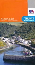
Wandelkaart 375 Isle of Mull East Argyl Schotland - OSI
Het op een na grootste eiland van de Binnen-Hebriden
Korte omschrijving
Wandelkaart Isle of Mull East - Argyl Schotland Productbeschrijving: Mull is het op een na grootste eiland van de Binnen-Hebriden in Argyll and Bute. 375 / Isle of Mull East, Argyl, Scho...

Specificaties
- Uitgever: Ordnance Survey
- ISBN-13: 9780319246221
- HOOFDCATEGORIEËN: Wandelkaart
- Activiteiten: Wandelen, Hiking & Trekking
- Regio: Argyl, Shotland
- Land: Schotland
- Schaal: 1:25000
- Afmeting: 13x23
- Taal: Engels
- Reeks: Explorer Series
Volledige omschrijving
Wandelkaart Isle of Mull East - Argyl Schotland
Productbeschrijving: Mull is het op een na grootste eiland van de Binnen-Hebriden in Argyll and Bute.
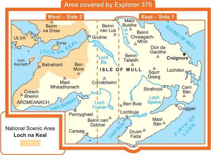
375 / Isle of Mull East, Argyl, Schotland - Kaart nummer 375 is een all purpose kaart vol gepakt met informatie om u het gebied te helpen leren kennen. De 204 Landranger-kaarten bestrijken het land. Elke kaart heeft een oppervlakte van 40 km door 40 km (25 mijl door 25 mijl) en zoals andere kaarten van Ordnance Survey, National Grid-vierkanten worden verstrekt zodat elke functie een unieke referentienummer kan worden gegeven.
375 / Isle of Mull East, Argyl, Schotland - These highly detailed maps show all the administrative boundaries, settlements as small as isolated farms, the road network down to unfenced roads and country tracks, and field boundaries (hedges and drystone walls) which make navigation across the countryside much easier. Steep gradients on roads are indicated. Various landmarks, e.g. powerlines, archaeological sites, windmills, churches and lighthouses are shown and additional graphics indicate natural terrain features such as cliffs, scree, mud and vegetation variations.
The contour interval is 5 metres in the lower parts of the country and 10 metres in the uplands, and spot heights are marked. Each map covers an area of 30 x 20km (i.e. approx. 19 x 12 miles), with some double-sided maps covering more, as indicated in the individual descriptions. The maps are fully GPS compatible, with the National Grid shown at 1km intervals and latitude and longitude indicated by margin ticks at 1'.
Locatie op kaart
Overzichtskaarten

OSI Explorer & Explorer Active - Hebriden - Isle of Skye
OSI Explorer & Explorer Active - Hebriden - Isle of Skye

Producten op de overzichtskaart
Klik op een product om naar de detailpagina te gaan.
- Wandelkaart 372 Coll & Tiree- Ayrshire & Lanark - OSI
- Wandelkaart 374 Isle of Mull North & Tobermroy - OSI
- Wandelkaart 375 Isle of Mull East- Argyl- Schotland - OSI
- Wandelkaart 397 Rum- Eigg- Muck- Canna & Sanday - OSI
- Wandelkaart 407 Isle of Skye & Dunvegan- Highland's - OSI
- Wandelkaart 408 Isl of Skye- Trotternish & The Storr - OSI
- Wandelkaart 409 Raasay- Rona & Scalpay- Inner Hybrids - OSI
- Wandelkaart 410 Isle of Skye- Portree & Bracadale - OSI
- Wandelkaart 411 Isle of Skye- Cuillin Hills Schotland- OSI
- Wandelkaart 412 Isle of Skye & Sleat- Schotland - OSI
- Wandelkaart 413 Knoydart- Loch Hourn & Loch Duich - OSI
- Wandelkaart 452 Barra & Vatersay- Western isles Highlands - OSI
- Wandelkaart 453 Benbecula & South Uist- Western Isles - OSI
- Wandelkaart 454 North Uist & Berneray- Outer Hybrids - OSI
- Wandelkaart 455 South Harris- Outer Hybrids Schotland - OSI
- Wandelkaart 456 North Harris & Loch Seaforth Outer Hibrids - OSI
- Wandelkaart 457 South East Lewis- Outer Hybrids Schotland - OSI
- Wandelkaart 458 West Lewis- Outer Hybrids Schotland - OSI
- Wandelkaart 459 Central Lewis & Stornoway - Outer hybrides - OSI
- Wandelkaart 460 North Lewis- Outer Hybrids Schotland - OSI

OSI Explorer & Explorer Active - Zuid West Schotland - Loch Lomond
OSI Explorer & Explorer Active - Zuid West Schotland - Loch Lomond

Producten op de overzichtskaart
Klik op een product om naar de detailpagina te gaan.
- Wandelkaart 326 Ayr & Troon- South Ayrshire - OSI
- Wandelkaart 327 Cumnock & Dalmellington - OSI
- Wandelkaart 333 Kilmarnock & Irvine- East Ayrshire - OSI
- Wandelkaart 341 Greenock- Largs & Millport - OSI
- Wandelkaart 342 Glasgow- Schotland - OSI
- Wandelkaart 352 Islay South- Argyl & Bute- Schotland - OSI
- Wandelkaart 353 Islay North- Argule & Bute Schotland - OSI
- Wandelkaart 354 Colonsay & Oronsay- Argyl & Bute - OSI
- Wandelkaart 355 Jura & Scarba- Inner Hibrids - OSI
- Wandelkaart 356 Kintyre South- Highlands-Schotland - OSI
- Wandelkaart 357 Kintyre North- Highlands-Schotland - OSI
- Wandelkaart 358 Lochgilphead & Knapdale North - OSI
- Wandelkaart 359 Oban- Kerrera & Loch Melfort - OSI
- Wandelkaart 360 Loch Awe & Inveraray- Argyl Schotland- OSI
- Wandelkaart 361 Isle of Arran - OSI
- Wandelkaart 362 Cowal West & Isle of Bute - OSI
- Wandelkaart 373 Iona- Staffa & Ross of Mull - OSI
- Wandelkaart 374 Isle of Mull North & Tobermroy - OSI
- Wandelkaart 375 Isle of Mull East- Argyl- Schotland - OSI
- Wandelkaart 377 Loch Etive & Glen Orchy- Schotland- OSI
- Wandelkaart OL37 Cowal East- Dunoon & Iverary - OSI
- Wandelkaart OL38 Loch Lomond South & Dumbarton - OSI
- Wandelkaart OL39 Loch Lomond North & Tyndrum - OSI
- Wandelkaart OL46 Trossachs- Callander & Aberfoyle - OSI
Artikelen uit dezelfde regio

Wandelkaart 354 Colonsay & Oronsay- Argyl & Bute - OSI • 9780319246054
Wandelkaart Colonsay & Oronsay - Argyl & Bute Schotland Productbeschrijving: 354 / Colonsay & Oronsay, Argyl & Bute, Schotland - Voor de westkust van Schotland, zijn Colonsay en Oronsay onderdeel van de Binnen-Hebriden en zijn gedekt door Explorer kaart 354. Het gebied staat bekend om haar vogelleven (mainy seabirds), en er zijn ook een aantal ruïnes. De OS Explorer kaart voor Colonsa…

Wandelkaart 374 Isle of Mull North & Tobermroy - OSI • 9780319246214
Wandelkaart Isle of Mull North & Tobermroy - Schotland Productbeschrijving: Ulva, Staffa & Treshnish Isles. 374 / Isle of Mull North & Tobermroy, Argyl, Schotland - Deze twee-zijdige kaarten tonen het noordelijk deel van het eiland Mull, met inbegrip van Tobermory, de hoofdstad van het eiland. Dit gebied bevat ook het eiland van Ulva en de Treshnish eilanden, die allemaal deel uit mak…

Wandelkaart 355 Jura & Scarba Argyl Schotland - OSI • 9780319246061
Wandelkaart Jura & Scarba - Argyl Schotland Productbeschrijving: 355 / Jura & Scarba, Argyl, Schotland - Kaart nummer 355 is een all purpose kaart vol gepakt met informatie om u het gebied te helpen leren kennen. De 204 Landranger-kaarten bestrijken het land. Elke kaart heeft een oppervlakte van 40 km door 40 km (25 mijl door 25 mijl) en zoals andere kaarten van Ordnance Survey, Nation…

Wandelkaart 357 Kintyre North- Schotland - OSI • 9780319472286
Wandelkaart Kintyre North - Argyl & Bute Schotland Omvat ook: Knapdale South & Isle of Gigha Tarbert. Productbeschrijving: OS Explorer kaart 357 heeft betrekking heeft op het noordelijk deel van Kintyre en zuidelijke Knapdate. Hoogtepunten van het gebied omvatten Kintyre way, Tarbert tot Skipness recreatieve pad, Beinn Bhreac en West Loch Targert. Deze kaart toont ook de Isle van Gigha…