
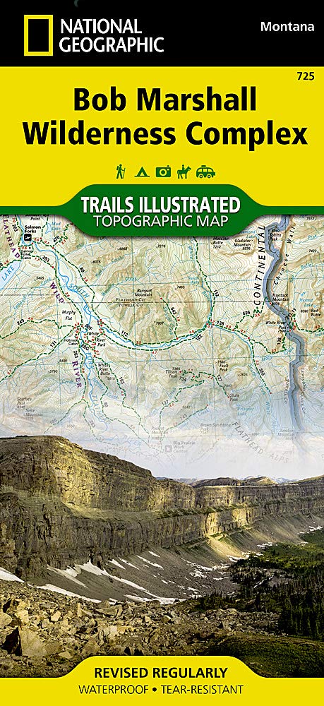
Wandelkaart 725 Bob Marshall Wilderness - Natgeo
Een samenstelling van prachtige beboste regio's
Korte omschrijving
TOPO Wandelkaart 725 - Bob Marshall Wilderness - Natgeo Productomschrijving: The Bob Marshall Wilderness Area is een op kaart gemaakte wilderness area gelegen in western Montana in de United...

Specificaties
- Uitgever: National Geographic
- ISBN-13: 9781597756266
- HOOFDCATEGORIEËN: Wandelkaart
- Activiteiten: Wandelen, Hiking & Trekking
- Regio: Montana, USA
- Land: Verenigde Staten van Amerika (USA)
- Regionale parken: Bob Marshall Wilderness, Montana USA
- Schaal: 1:126720
- Afmeting: 11x24
- Taal: Engels
Volledige omschrijving
TOPO Wandelkaart 725 - Bob Marshall Wilderness - Natgeo
Productomschrijving: The Bob Marshall Wilderness Area is een op kaart gemaakte wilderness area gelegen in western Montana in de United States. Dit wildernis, samen met de aanpalende bossen Scapegoat- en Great Bear wildernes, maken samen het "Bob Marshall Wilderness Complex".
Engelse omschrijving: Located just north of Yellowstone National Park, Absaroka-Beartooth Wilderness is known for it high peaks and alpine plateaus. Experienced and novice outdoor enthusiasts alike will marvel at National Geographic's Trails Illustrated map of Absaroka-Beartooth Wilderness West. Expertly researched and created in cooperation with the National Park Service, U.S. Forest Service and others, the map delivers unparalleled detail of the western half of the wilderness. Coverage includes many popular recreation areas, such as the Gallatin National Forest, Absaroka Range, East and West Boulder Plateaus, Yellowstone and Boulder Rivers, Mammoth Hot Springs and the northern part of Yellowstone Park, Paradise Valley and part of Custer National Forest.
Let the map guide you off the beaten path and back on again with clearly marked trails, shown with mileage markers and labeled according to designated use, whether exploring on foot, horseback, mountain bike, ATV, motorcycle, skis or snowmobile. Your navigation will be aided by the map's contour lines with elevations, labeled peaks, summits and plateaus, water features, glaciers and snowfields, areas of wooded cover and color-coded boundaries between different land management agencies as well as a complete road network to lead you in and out of the area.
Recreation features pinpointed include campgrounds and campsites, public cabins, trailheads, interpretive trails, fishing holes and wildlife viewing areas. QR codes provide quick access to hunting and fishing regulations and licensing. Every Trails Illustrated map is printed on "Backcountry Tough" waterproof, tear-resistant paper. A full UTM grid is printed on the map to aid with GPS navigation.
Other features found on this map include: Absaroka-Beartooth Wilderness, Buffalo Plateau, Custer National Forest, Emigrant Peak, Gallatin National Forest, Lake Plateau, Lamar River, Mount Cowen, Mount Wallace, Yellowstone National Park.
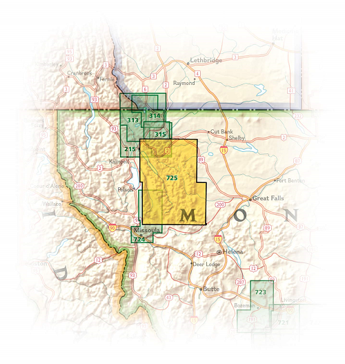
Locatie op kaart
Artikelen uit dezelfde regio

Wandelkaart 721 Absaroka - Beartooth Wilderness - Montana • 9781566955812
Wandelkaart 721 - Absaroka - Beartooth Wilderness - Montana Productomschrijving: In het Amerikaanse Montana en Wyoming, ligt dit prachtige Absorka Wilderness gebied, waar er dag van vandaag nog steeds wilde paarden rondlopen. Het gebied staat bekend voor zij schitterende vergezichten, en horizon om U tegen te zeggen. De kaart is gedetailleerd en beschikt over alle noodzakelijk details om e…

Wandelkaart 201 Yellowstone NP- Wyoming - Nat Geo • 9781566952958
TOPO Wandelkaart 201 - Yellowstone NP- Wyoming - Nat geo Productomschrijving: Yellowstone National Park, wat een prachtig concept voor een nationaal park, een par van formaat, en een nationaal park in de Verenigde Staten, hoofdzakelijk in Wyoming, maar met kleine gedeeltes in de aangrenzende staten Montana en Idaho. Engelse omschrijving: National Geographic's Trails Illustrated map of …


Wandelkaart 302 Yellowstone NP & Old Faithful - Nat Geo • 9781566954334
Yellowstone National Park & Old Faithful - Nat Geo Omvat: Craig Pass, Gallatin National Forest, Grand Teton National Park, Heart Lake, Jedediah Smith Wilderness, John D. Rockefeller, Jr. Memorial Parkway, Lewis Lake, Mount Sheridan, Pitchstone Plateau, Red Mountains, Shoshone Lake, Targhee National Forest, Teton National Forest, Teton Wilderness, Yellowstone National Park. Engelse omsc…

Wandelkaart 314 Many Glacier NP- Waterton lakes - Montana • 9781566954709
TOPO Wandelkaart 314 - Many Glacier NP- Waterton lakes Productomschrijving: Many Glacier is een locatie binnen het Glacier National Park gelegen in de U.S. in de staat van Montana Engelse omschrijving: Created in partnership with local land management agencies, National Geographic's Trails Illustrated map of Many Glacier, Glacier and Waterton Lakes National Parks offers unparalleled de…

Wandelkaart 313 North Fork- Glacier National Park - Nat Geo • 9781566954693
North Fork river - Glacier National Park - Nat Geo Productomschrijving: National Geographic's Trails Illustrated kaart van North Fork in Glacier National Park zal zelfs de meest ervaren buitensportliefhebber ten goede komen, bij het verkennen van dit ongerepte landschap dat zeer weinig voorzieningen heeft. Twee extra kaarten voor Many Glacier en de Two Medicine regio's van het park, samen…