
Wandelkaart 742 Adirondack Park - Lake Placid - Natgeo
Lake Placid- Essex County in New York
Korte omschrijving
TOPO Wandelkaart 742 - Adirondack Park - Lake Placid Productomschrijving : Adirondack park of mountains, een groter bebost deel van de staat New York. In dit geval gaat het over de locatie v...

Specificaties
- Uitgever: National Geographic
- ISBN-13: 9781566953573
- HOOFDCATEGORIEËN: Wandelkaart
- Regio: New York State, USA
- Land: Verenigde Staten van Amerika (USA)
- Regionale parken: Adirondack Park/Mountains NY, USA
- Schaal: 1:75000
- Afmeting: 10x19, 11x24
- Taal: Engels
Volledige omschrijving
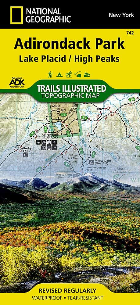
TOPO Wandelkaart 742 - Adirondack Park - Lake Placid
Productomschrijving : Adirondack park of mountains, een groter bebost deel van de staat New York. In dit geval gaat het over de locatie van Lake Placid, New York. Lake Placid is niet enkel een maar maar ook een kleine stad, in Essex County in New York.
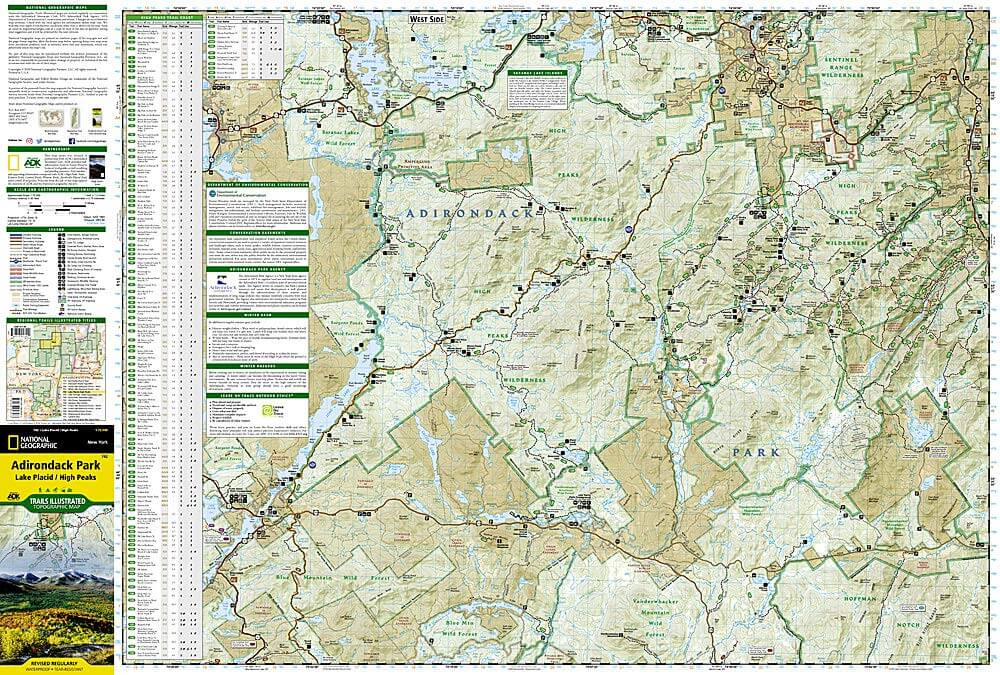
Engelse omschrijving : The largest park in the contiguous United States, Adirondack Park is a diverse mountain landscape of protected boreal forests and pristine waterways interspersed with over one hundred towns and villages. National Geographic's Trails Illustrated map of Adirondack Park combines unmatched detail with helpful information to offer an invaluable tool for making the most of your visit to this extraordinary region. Created in partnership with local land management agencies, this expertly researched map features key areas of interest including High Peaks Wilderness, Lake Placid, Sentinel Range Wilderness, Saranac Lakes Wild Forest, Lake Champlain, Giant Mountain Wilderness, Hurricane Mountain Wilderness, Split Rock Mountain Wild Forest, and Long Lake.
An extensive High Peaks Trail Chart will help you choose a trail that's right for your activity level and recreation use whether you're hiking, horseback riding, biking, snowshoeing, cross country skiing, or snowmobiling. Trails are clearly marked and include mileages between intersections. The map base includes contour lines and elevations for summits, passes and major lakes. Some of the many recreation features include: campgrounds, trailheads, fishing access, boat launch sites, and interpretive trails. Every Trails Illustrated map is printed on "Backcountry Tough" waterproof, tear-resistant paper. A full UTM grid is printed on the map to aid with GPS navigation.
Other features found on this map include: Adirondack Mountains, Algonquin Peak, Ampersand Mountain, Ausable River, Basin Mountain, Boundary Peak, Dix Mountain, Gothics, Gray Peak, Iroquois Peak, Little Marcy, MacIntyre Mountains, Mount Haystack, Mount Marcy, Mount Skylight, Otter Creek, Owls Head Mountain, Sentinel Range, Split Rock Mountain, Street Mountain, Tupper Lake, Upper Saranac Lake, Vanderwhacker Mountain.
Locatie op kaart
Overzichtskaarten

NAT GEO New York trail map
NAT GEO New York trail map

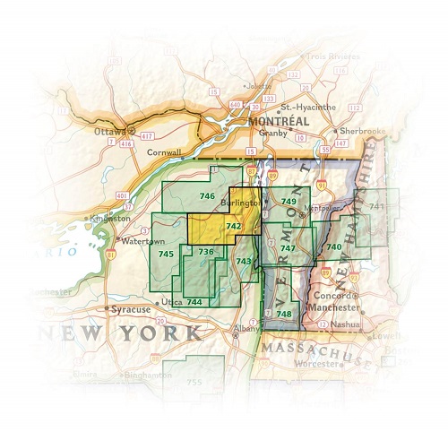
Producten op de overzichtskaart
Klik op een product om naar de detailpagina te gaan.
- Wandelkaart 738 Allegheny National Forest North - Nat Geo
- Wandelkaart 742 Adirondack Park - Lake Placid - Natgeo
- Wandelkaart 745 Adirondack Park - Old Forge & Oswegatchie
- Wandelkaart 746 Adirondack Park - Saranac & Paul Smiths
- Wandelkaart 747 Green Mountain National Forest- Vermont
- Wandelkaart 743 Adirondack Park - Lake George - Natgeo
- Wandelkaart 744 Adirondack Park - Northville & Raquette Lake
- Wandelkaart 748 Green Mountain National Forest
- Wandelkaart 756 Harriman- Bear Mountain & Sterling Forest parks
Artikelen uit dezelfde regio

Wandelkaart 746 Adirondack Park - Saranac & Paul Smiths • 9781566953726
TOPO Wandelkaart 746 - Adirondack Park - Saranac & Paul Smiths Productomschrijving: Adirondack park of mountains, een groter bebost deel van de staat New York. In dit geval gaat het over Saranac Lake & Paul Smiths dorp. Het dorp Saranac Lake omvat stukjes van 3 verschillende dorpen, Harrietstown, St. Armand- en North Elba, Als ook twee regio's Franklin & Essex. Engelse omschrijving: Ex…

Reisgids New York city - Lonely Planet • 9781786570673
New York city - Lonely Planet Coverage Includes: Lower Manhattan & the Financial District, SoHo & Chinatown, East Village & Lower East Side, West Village, Chelsea & the Meatpacking District, Union Square, Flatiron District & Gramercy, Midtown, Upper East Side, Upper West Side & Central Park, Harlem & Upper Manhattan, Brooklyn, Queens. Product description: Epicenter of the arts. Dining…

Wandelkaart 745 Adirondack Park - Old Forge & Oswegatchie • 9781566954198
Topografische Wandelkaart 745 - Adirondack Park - Old Forge & Oswegatchie, New York State. Productomschjrijving: Adirondack park of mountains, een groter bebost deel van de staat New York. In dit geval gaat het over Old Forge, een bekende toegang tot het Old Forge deel van het pak. De locatie blijft een principieel toeristische regio, en zoals reeds vermeld, één van de westelijk gelegen to…

Wandelkaart 756 Harriman- Bear Mountain & Sterling Forest parks • 9781566956079
Harriman- Bear Mountain & Sterling Forest State Parks - Nat Geo Engelse omschrijving: At over 46,000 acres, Harriman State Park is the second largest state park in New York and is located only 30 miles north of New York City. It is a haven for hikers with over 200 miles of trails, and water-sport enthusiasts flock to its three beaches and 31 lakes and reservoirs. On the northeastern edge, …

Reisgids New York Mini Rough Guide • 9781785732379
New York van Mini Rough Guide Productomschrijving: Deze gids in zakformaat is een handige, snelle referentiegids om te ontdekken wat er te doen is, wat er te zien is en hoe je je in New York kunt verplaatsen. Het behandelt topattracties zoals het Empire State Building, maar ook verborgen juweeltjes, zoals de High Line. Zo bespaar je tijd en ontdek je deze fascinerende stad nog beter. O…