
Wanderlkaart 222 Denali NP- Alaskan Range - Alaska - Natge
Met een dikke 24,464 km2 groot- die groter is dan West-Vlaanderen
Korte omschrijving
TOPO Wanderlkaart 222 - Denali NP- Alaskan Range - Nat Geo Productomschrijving: Denali National Park and Preserve is een Amerikaans nationaal park, in het binnenland van Alaska. In centraal ...

Specificaties
- Uitgever: National Geographic
- ISBN-13: 9781566953283
- HOOFDCATEGORIEËN: Wandelkaart
- Activiteiten: Wandelen, Hiking & Trekking
- Regio: Alaska, USA
- Land: Verenigde Staten van Amerika (USA)
- Nationale parken: Delani NP and reserve
- Schaal: 1:225000
- Afmeting: 10x19
- Taal: Engels
Volledige omschrijving
TOPO Wanderlkaart 222 - Denali NP- Alaskan Range - Nat Geo
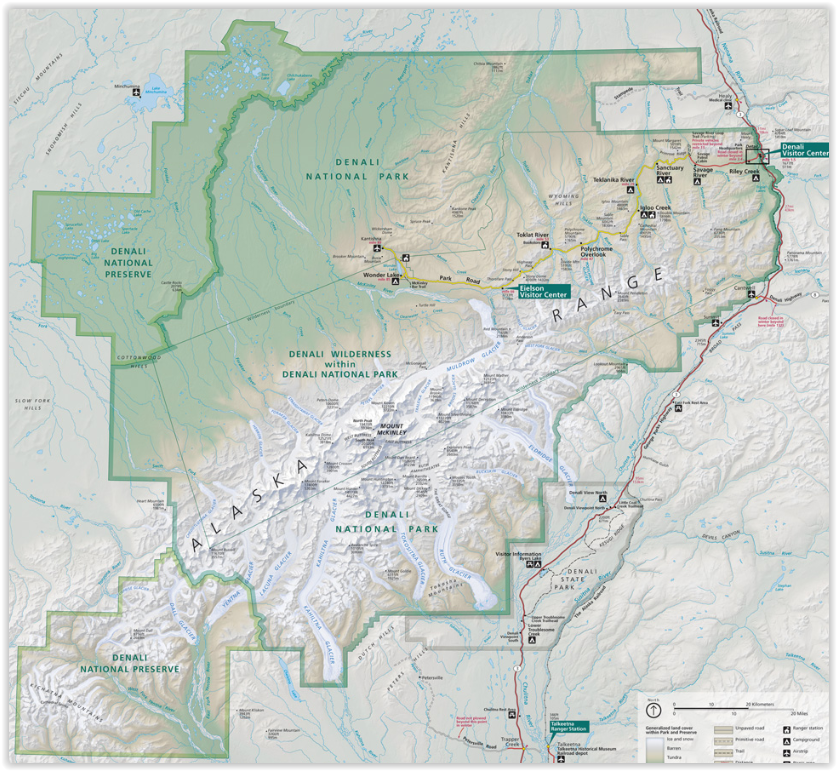
Productomschrijving: Denali National Park and Preserve is een Amerikaans nationaal park, in het binnenland van Alaska. In centraal Denali, ligt de hoogste berg van noord Amerika. Compleet gezien is het park een dikke 24,464 km2 groot, die groter is dan West-Vlaanderen. Het Denali landschap is een mix van bos op zijn lager gelegen plaatsen, met de tundra in zijn midden gelegen plaatsen, en gletjers, sneeuw & rotsen op de hoger gelegen delen. De langste gletjer is ddie met naam Kahiltna Glacier. Winter activiteiten zijn dog sledding, cross-country skiing, en snowmobiling.
Engelse omschrijving: Denali National Park and Preserve covers a staggering six million acres of truly wild and pristine wilderness, bisected by a single road. The crown jewel of the park is the towering 20,320 foot Mount McKinley, North America's tallest peak. Expertly researched and created in partnership with local land management agencies, National Geographic's Trails Illustrated map of Denali National Park provides an unparalleled tool for exploring this remarkable region. Key areas of interest featured on this map include Denali State Park; Kroto, Moose Creek, and Lake Creek recreation rivers; Lake Minchumina; and the Kantishna Mining District. The print version of the map includes a detailed inset of the park entrance and headquarters.
If you wish to camp in the park, a chart of campground information that includes the distance from the entrance, number and type of spaces, facilities, access, and contact information for making your reservations will help you plan your stay. Private vehicle travel in the park is limited, but this map's coverage of the shuttle bus system will ensure you have the knowledge you need to access the entire park. Helpful information about regulations, avoiding close encounters with bears, hiking in the Kantishna Mining District, and safety tips, as well as clearly marked campgrounds, rental cabins, bush airstrips, trailheads, and more will help you enjoy all the park has to offer. The map base includes contour lines and elevations for summits, passes and many lakes. Every Trails Illustrated map is printed on "Backcountry Tough" waterproof, tear-resistant paper. A full UTM grid is printed on the map to aid with GPS navigation.
Other features found on this map include: Bear Creek, Birch Creek, Broad Pass, Browne Tower, Chelatna Lake, Chulitna River, Chunilna Creek, Dall Glacier, Denali National Park, Denali National Preserve, East Buttress, Eldridge Glacier, Foraker River, Herron River, Kahiltna Glacier, Lacuna Glacier, Lake Minchumina, McKinley River, Moose Creek, Mount Foraker, Mount Hunter, Mount Mather, Mount McKinley, Muldrow Glacier, Portage Creek, Ruth Glacier, Sheep River, South Buttress, Stephan Lake, Talkeetna River, Tokositna Glacier, Yanert Fork, Yentna Glacier.
Artikelen uit dezelfde regio

Wandelkaart 248 Katmai NP- Alaska - Nat Geo • 9781566952903
TOPO Wandelkaart 248 - Katmai NP- Alaska - Nat Geo Productomschrijving: Katmai National Park is een Amerikaans nationaal park in het zuiden van de staat Alaska, gelegen op het Alaska-schiereiland. Het ligt ongeveer 450 kilometer ten zuidwesten van de stad Anchorage. Het gebied is alleen per boot of vliegtuig te bereiken. Engelse omschrijving: Known for its large population of bears an…

Reisgids Alaska - Eyewitness • 9780241411520
Reisgids Alaska - Eyewitness Productomschrijving: Tour the mighty Mendenhall Glacier, ride the Alaska Marine Highway or brave the cold to catch a glimpse of the mesmerising Northern Lights (Aurora Borealis): everything you need to know is clearly laid out within colour-coded chapters. Discover the best of Alaska with this indispensable travel guide. Inside DK Eyewitness Travel Guide Al…

Reisgids Alaska Escapade dans le Yukon - Petit Futé • 9782305078830
Alaska & Escapade dans le Yukon - Petit Futé Productomschrijving: Welkom in een van de laatste overgebleven natuurlijke paradijzen op onze prachtige planeet. Besneeuwde toppen zover het oog reikt, immense bossen, toendra's die trillen onder de hoeven van kariboes, otters die tussen de walvissen doorscharrelen aan de voet van enorme gletsjers, kale adelaars die de rivieren afspeuren - de na…

Wandelkaart 249 Wrangell St.Elias NP - Nat.Geo. • 9781566953825
Wrangell St.Elias NP - National Geographic Productomschrijving: Met 13,2 miljoen hectare, zou Wrangell-St. Elias binnen de grenzen passen van Yellowstone, Grand Canyon, Glacier, Olympic en Yosemite National Parks met zelf nog ruimte over. Het strekt zich uit van een van de hoogste toppen van Noord-Amerika > Mount Stain Elias, tot aan de oceaan. Meer dan een kwart van het park is bedekt met…

Wandelkaart 763 Kachemak Bay State Park - Alaska - Nat Geo • 9781566950749
Wandelkaart Kachemak Bay State Park, Homer Alaska Omvat: Anchor Point, Chugach Islands, Fox River, Gore Point, Kachemak Bay, Kalgin Island, Kenai Fjords National Park, Kennedy Entrance, Nuka Bay, Nuka Island, Point Adam, Point Pogibshi, Port Dick, Tustumena Lake. Engelse omschrijving: Outdoor enthusiasts exploring the various public recreation lands in the southwestern part of the Kena…