
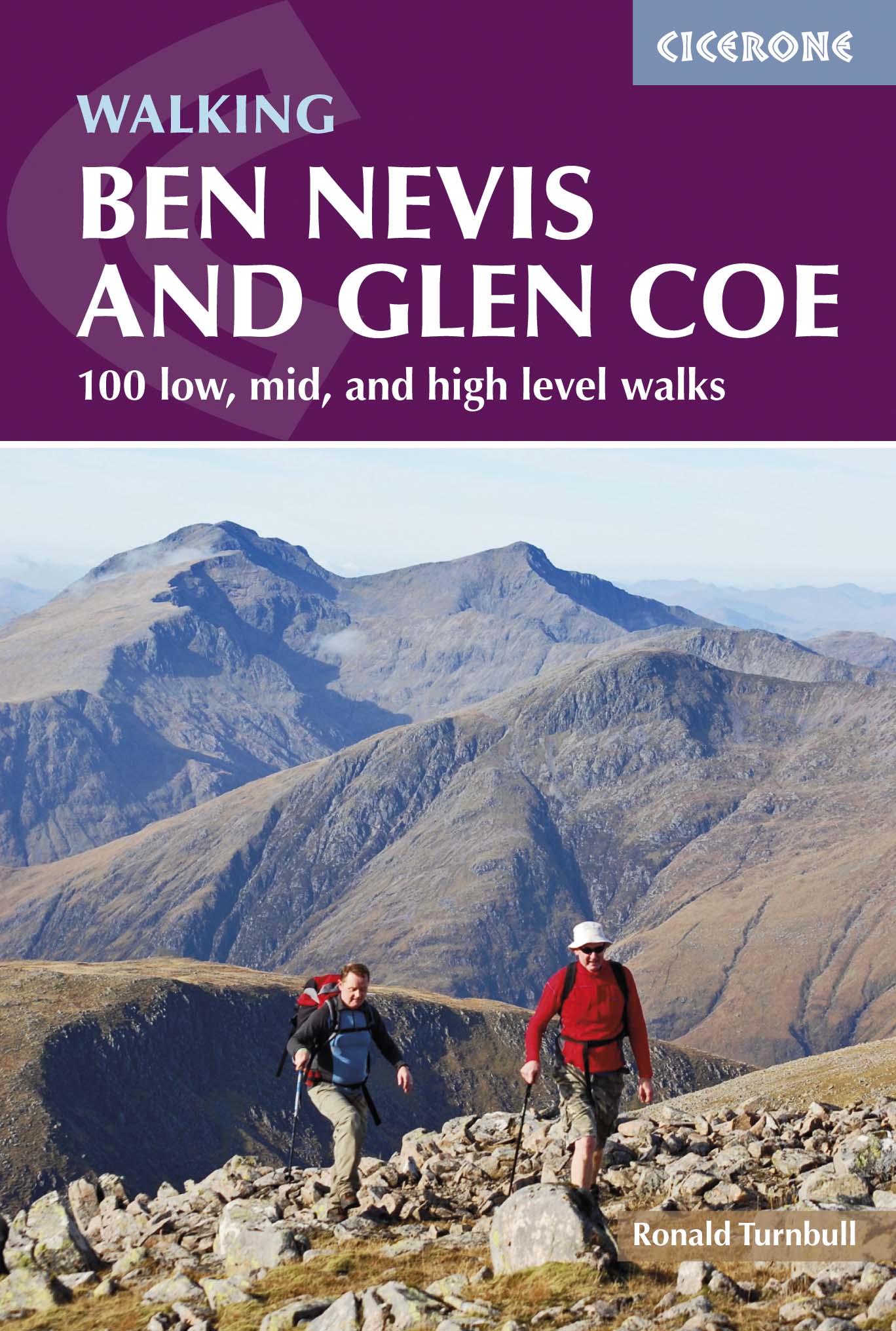
Wandelgids Ben Nevis & Glen Coe Schotland - Cicerone
Wandelingen in de buurt van Kinlochleven & Fort William
Korte omschrijving
Wandelgids - Ben Nevis & Glen Coe Schotland - Cicerone Productomschrijving: Wandelgids voor de regio van Schotland, de Ben Nevis en Glen Coe, en omvat 100 ingedeelde routes van tussen de 2 t...

Specificaties
- Uitgever: CICERONE Press
- ISBN-13: 9781852848712
- HOOFDCATEGORIEËN: Wandelgids
- Activiteiten: Wandelen, Hiking & Trekking
- Regio: Highlands, Schotland
- Land: Schotland
- Blz.: 312, 320
- Afmeting: 12x17
- Editie: 2
- Taal: Engels
Volledige omschrijving
Wandelgids - Ben Nevis & Glen Coe Schotland - Cicerone
Productomschrijving: Wandelgids voor de regio van Schotland, de Ben Nevis en Glen Coe, en omvat 100 ingedeelde routes van tussen de 2 tot en met 26km. De routes variëren van zachte wandelingen tot Bothy treks en omvatten 43 Munro's en 3 scrambles. De routes omvatten wandelingen in de buurt van Kinlochleven, Fort William, de Grey Corries, de Mamores, de Black Mount en Ben Crúachan.
Product description: Guidebook to walking in Scotland's Ben Nevis and Glen Coe region, featuring 100 graded walks of 2 to 21 miles. The routes range from gentle walks to bothy treks and cover 43 Munro summits and 3 scrambles. The routes include walking near Kinlochleven, Fort William, the Grey Corries, the Mamores, the Black Mount and Ben Cruachan.
Seasons:
Low-level walks and scrambles: April to end of October recommended. High-level routes: snow on tops Dec to April or later. July to Sept: beware of midges.
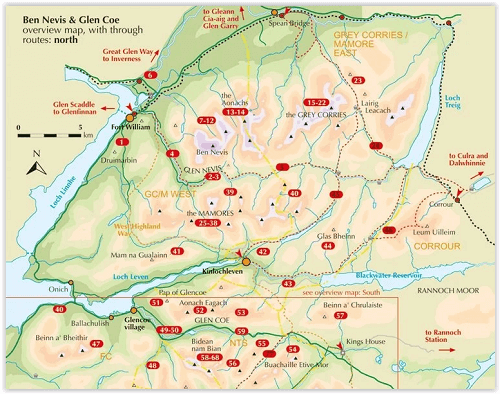
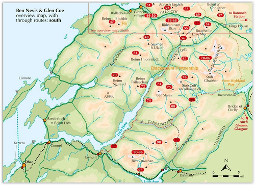
Centres:
Fort William, Glen Nevis, Spean Bridge, Corrour Station, Kinlochleven, Glencoe, Orchy, Inveroran, Dalmally, Taynuilt, Oban.
Difficulty:
High, low and mid-level walks: all graded for length and difficulty. Also some longer treks and through-routes. Variety of walking routes suitable for all abilities.
Must See:
44 Munro summits, Aonach Eagach ridge scramble, the Grey Corries, the Black Mount, Bidean, Ben Cruachan, Nevis Gorge, Carn Mor Dearg Arête, Ring of Steall, Cruachan Horseshoe, climb Ben Nevis.
Locatie op kaart
Artikelen uit dezelfde regio

Reisgids Schotland's Highlands & Islands - Lonely Planet • 9781787016439
Schotland's Highlands & Islands - Lonely Planet Productomschrijving: The hills and glens and wild coastline of Scotland’s Highlands and islands offer the ultimate escape – one of the last corners of Europe where you can discover genuine solitude. Lonely Planet will get you to the heart of Scotland’s Highlands & Islands, with amazing travel experiences and the best planning advice: …

Wandelkaart XT25 Fannichs Seana Bhraigh - Harvey Maps • 9781851376209
Wandelkaart XT25 - Fannichs Seana Bhraigh & Ben Wyvis - Harvey Maps Productomschrijving: Een locatie in de Noordelijke Schotse Highlands, gelegen bij de bekende berg Ben Wyvis, meerbepaald ten oostenlijke Ross, noordwestelijk gelegen van Dingwall in het noorden van Schotland. Opgelet, deze locaties zijn voor ervaren hikers, de locatie is niet geschikt voor onervaren mensen. De precieze…

Wandelkaart 27 Nairn & Forres Highland's Schotland - OSI • 9780319473504
Wandelkaart Nairn & Forres - Highland's Schotland Productbeschrijving: OS Landranger kaart 27 toont Moray Firth, net ten oosten van Inverness. De kust stad van Nairn is een populaire vakantiebestemming, of neem de Moray Coastal Trail langs Forres aan Findhorn. De OS Landranger kaarten reeks heeft betrekking op Groot-Brittannië met 204 gedetailleerde kaarten, perfect voor dagtochten en kort…

Mountainbikegids West & Norh West Schotland - Cicerone • 9781852847463
Mountainbikegids - West & Norh West Schotland - Cicerone Productomschrijving: Deze gids beschrijft 25 mountainbike routes in Noord- en Noord West Schotland, een gebied met inbegrip van Fort William, Rannoch Moor, Glen Spean, Invergarry, Loch Sunart, Strathfarrar, Kinlochewe, Sutherland, de Buiten-Hebriden en de bergen van Torridon. De routes variëren van 19,5 km tot 73.25 km, blauw, rood o…

Wandelkaart 26 Ben Nevis- Fort William & Glen Coe - AA • 9780749573089
Wandelkaart 26 - Ben Nevis- Fort William & Glen Coe - AA Productomschrijving: AA, in samenwerking met Ordinance Survey, heeft een reeks kaarten ontwikkeld die zich op populaire toeristische bestemmingen van de UK richten, zodat meerdere OS-kaarten niet vereist zijn. Deze kaart richt zich op Ben Nevis, Fort William en Glen Coe uit Brugnera in het oosten aan Glenfinnan in het westen en uit B…