
Wandelgids Walking the Munros Vol 1 - Cicerone Press
69 challenging routes across Glencoe- Bridge of Orchy and Mull

Korte omschrijving
Walking the Munros Vol 1 - Cicerone Productomschrijving: Wandelgids over de Munros in de zuidelijke, centrale en westelijke Highland's. De gids beschrijft 69 uitdagende routes over 139 van d...

Specificaties
- Uitgever: CICERONE Press
- ISBN-13: 9781786311054
- HOOFDCATEGORIEËN: Wandelgids
- Activiteiten: Wandelen, Hiking & Trekking
- Auteur: Steve Kew
- Regio: Highlands, Schotland
- Land: Schotland
- Blz.: 272
- Afmeting: 12x17
- Editie: 4
- Taal: Engels
Volledige omschrijving
Walking the Munros Vol 1 - Cicerone
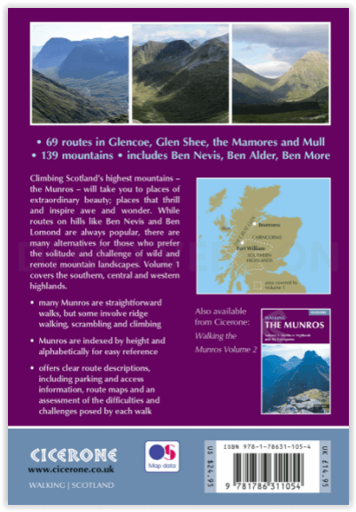
Productomschrijving: Wandelgids over de Munros in de zuidelijke, centrale en westelijke Highland's. De gids beschrijft 69 uitdagende routes over 139 van de meest iconische 3000f+ bergen in gebieden zoals Glencoe, Bridge of Orchy en Mull. Inclusief routes op Ben More, Ben Alder, Ben Lomond en Ben Nevis, de hoogste berg van de Britse eilanden. Deel 1 van twee reisgidsen.
Engelse omschrijving: Guidebook to walking the Munros in southern, central and western Highlands. Describes 69 challenging routes across 139 of the iconic 3000ft+ mountains covering areas such as Glencoe, Bridge of Orchy and Mull. Includes routes up Ben More, Ben Alder, Ben Lomond and Ben Nevis, the highest mountain in the British Isles. Volume 1 of two guidebooks.
Seasons:
Year-round mountain walking, with summer walking in mind. However, midges may hold you back in summer, and if snow's not your thing then avoid winter.
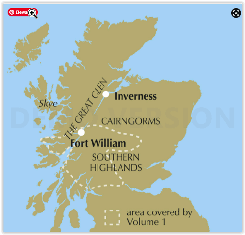
Centres:
Fort William, Glencoe, Killin, Pitlochry, Blair Atholl, Oban and many more.
Difficulty:
Many Munros are straightforward walks, but some have exciting ridge walking and scrambling. Aonach Eagach is covered in this volume. Normal Scottish mountain challenges and precautions.
Must See:
The extroardinary beauty of Scotland's mountain landscape; the challenge of a long and strenuous climb; the achievement of the summit; the sight of wilderness stretching out for miles around; the tidal wave of cloud flowing over a ridge; the sweet peace of that first refreshment at the end of the day.
Locatie op kaart
Artikelen uit dezelfde regio

Wandelkaart 383 Morvern & Lochaline- Schotland - OSI • 9780319472491
Wandelkaart Morvern & Lochaline- Highland Schotland Omvat ook: Kingairloch. Productbeschrijving: Kaart blad nummer 383 in de OS Explorer kaarten reeks omvat Morvern en Lochaline in de Schotse Hooglanden. Dit schilderachtige gebied beschikt over vele Lochs om te verkennen, met inbegrip van Loch Linnhe, Loch Aline en Loch Sunart samen met de Sound of Mull. De steden Kingairloch en Lochal…

Wandelkaart 414 Glen Shiel & Kintail Forest Schotland OSI • 9780319472699
Wandelkaart Glen Shiel & Kintail Forest - Highland's Schotland Omvat ook: Shiel Bridge, Morvich, Killilan & Kinloch Hourn. Productbeschrijving: Als u van plan bent om zoveel Munros mogelijk af te lopen, gaat u deze OS Explorer kaart 414 nodig hebben. Met 32 Munros op één dubbelzijdige kaart heeft dit gebied ook drie nationale natuurgebieden, Loch Cluanie en Loch Quoich. De OS Explorer …

Wandelkaart 16 Lairg & Loch Shin Highland's Schotland - OSI • 9780319261149
Wandelkaart Lairg & Loch Shin - Highland's Schotland Productbeschrijving: OS Landranger kaart 16 toont het gebied rondom Loch Shin en Loch Naver, met inbegrip van Lairg en Oykel Bridge. Er valt ook een fietsroute langs de schilderachtige A836 te vinden, of u kunt een bezoek brengen aan de watervallen van Shin. De OS Landranger kaarten reeks heeft betrekking op Groot-Brittannië met 204…

Wandelgids Schottland - West Highland Way - Rother • 9783763347261
The West Highland Way 153 km - Rother Productomschrijving: Op de West Highland Way leer je de mooiste kanten van Schotland te voet kennen: Vanaf de bewoonde uitlopers van Glasgow in de Lowlands leidt dit 150 kilometer lange pad naar het hart van de Highlands bij Fort William. Het Schotse landschap ziet er hier uit als iets uit een prentenboek: het pad voert door ongerepte heidevelden, over…

Wandelkaart 57 Stirling & The Trossachs NP Schotland - OSI • 9780319261552
Wandelkaart Stirling & The Trossachs NP - Schotland Productbeschrijving: OS Landranger kaart 57 van Stirling & The Trossachs, omvat ook Ben Vorlich, Mor Bheinn, Ling Hill, Ben Ledi, Venachar Loch, Loch Katrine, Loch Ard evenals deel van de Loch Lomond en de Trossachs nationaal park. Stirling en het kasteel is zeker een bezoekje waard, terwijl het nabijgelegen Wallace Monument in een indruk…