
Wandelkaart 103 The Lizard Cornwall England - OSI
Verken de locaties- The Lizard- Falmouth & Helston

Korte omschrijving
Wandelkaart The Lizard - South west England - OSI Omvat ook: Falmouth & Helston. Productbeschrijving: Kaart nummer 103 in de OS Explorer kaarten reeks is de ideale kaart voor het verkenn...

Specificaties
- Uitgever: Ordnance Survey
- ISBN-13: 9780319243053
- HOOFDCATEGORIEËN: Wandelkaart
- Activiteiten: Wandelen, Hiking & Trekking
- Regio: South West England
- Land: England
- AONB - Area of Outstanding Beauty: Cornwall, AONB
- Schaal: 1:25000
- Afmeting: 13x23
- Taal: Engels
- Reeks: Explorer Series
Volledige omschrijving
Wandelkaart The Lizard - South west England - OSI
Omvat ook: Falmouth & Helston.
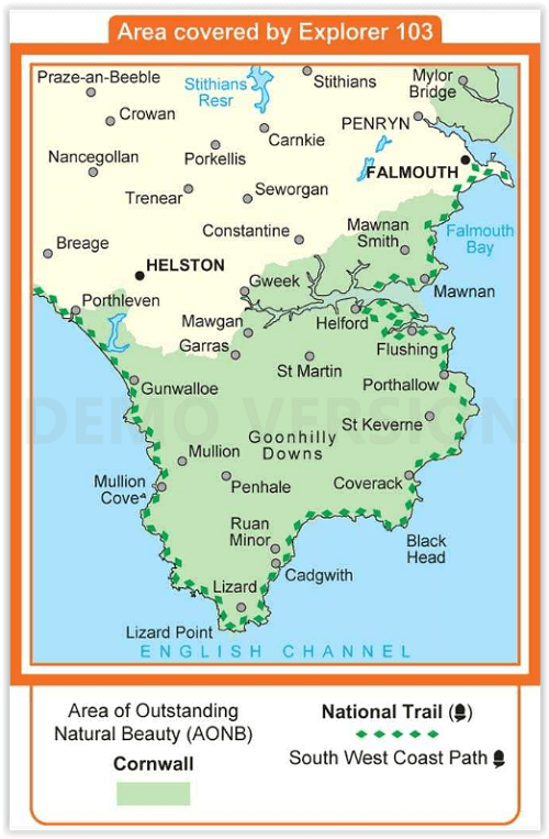
Productbeschrijving: Kaart nummer 103 in de OS Explorer kaarten reeks is de ideale kaart voor het verkennen van The Lizard, Falmouth en Helston. Hoogtepunten van het gebied zijn onder andere: Falmouth, Goonhilly Downs, Mullion Cove, Lizard Point, Bumble Rock, Cornwall Maritime Museum, Porthleven en de South West Coast Path. De OS Explorer kaart voor The Lizard is beschikbaar in zowel de standaard papieren versie als de weerbestendige 'Actief' versie.
National trail: Sout West Coast Path - AONB: Cornwall
Productdiscription: Map sheet number 103 in the OS Explorer map series is the ideal map for exploring The Lizard, Falmouth and Helston. Highlights of the area include: Falmouth, Goonhilly Downs, Mullion Cove, Lizard Point, Bumble Rock, Cornwall Maritime Museum, Porthleven and the South West Coast Path. The OS Explorer map for The Lizard is available in both the standard paper version and weatherproof 'Active' version.
Locatie op kaart
Gekoppelde artikelen

Wandelkaart 103 The Lizard Cornwall England - OSI • 9780319243053
standaard versieWandelkaart The Lizard - South west England - OSI Omvat ook: Falmouth & Helston. Productbeschrijving: Kaart nummer 103 in de OS Explorer kaarten reeks is de ideale kaart voor het verkennen van The Lizard, Falmouth en Helston. Hoogtepunten van het gebied zijn onder andere: Falmouth, Goonhilly Downs, Mullion Cove, Lizard Point, Bumble Rock, Cornwall Maritime Museum, Porthleven en de Sout…

Wandelkaart 103 The Lizard- Cornwall England - OSI • 9780319469842
weatherproof versieWandelkaart The Lizard - Cornwall England - OSI Productbeschrijving: Kaart nummer 103 in de OS Explorer kaarten reeks is de ideale kaart voor het verkennen van The Lizard, Falmouth en Helston. Hoogtepunten van het gebied zijn onder meer: Falmouth, Goonhilly Downs, Mullion Cove, Lizard Point, Bumble Rock, Cornwall Maritime Museum, Porthleven en de South West Coast Path. De OS Explorer kaart…
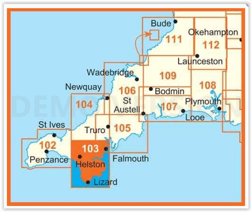
Overzichtskaarten

OSI Explorer & Explorer Active - Z.W. England Devon - Cornwall
OSI Explorer & Explorer Active - Z.W. England Devon - Cornwall

Producten op de overzichtskaart
Klik op een product om naar de detailpagina te gaan.
- Wandelkaart 102 Land's End - OSI
- Wandelkaart 102 Land's End - OSI
- Wandelkaart 103 The Lizard- Cornwall England - OSI
- Wandelkaart 103 The Lizard- Cornwall England - OSI
- Wandelkaart 104 Redruth & St Agnes- Cornwall - OSI
- Wandelkaart 104 Redruth & St Agnes- Cornwall - OSI
- Wandelkaart 105 Falmouth & Mevagissey - Cornawall - OSI
- Wandelkaart 105 Falmouth & Mevagissey - Cornawall - OSI
- Wandelkaart 106 Newquay & Padstow - Cornwall - OSI
- Wandelkaart 106 Newquay & Padstow- Cornwall - OSI
- Wandelkaart 107 St-Austell & Liskeard- Cornwall - OSI
- Wandelkaart 107 St-Austell & Liskeard & Fowey- Cornwall - OSI
- Wandelkaart 108 Lower Tamar Valley & Plymouth - OSI
- Wandelkaart 108 Lower Tamer Valley & Plymouth- Cornwall - OSI
- Wandelkaart 109 Bodmin Moor- Cornwal - OSI
- Wandelkaart 109 Bodmin Moor- Cornwal - OSI
- Wandelkaart 111 Bude- Boscastle & Tintagel- Devon - OSI
- Wandelkaart 111 Bude- Boscastle & Tintagel- Devon - OSI
- Wandelkaart 112 Launceston & Holsworthy- Devon - OSI
- Wandelkaart 112 Launceston & Holsworthy- Devon - OSI
- Wandelkaart 113 Okehampton- Devon England - OSI
- Wandelkaart 113 Okehampton- Devon England - OSI
- Wandelkaart 114 Exeter & Exe Valley- Devon - OSI
- Wandelkaart 114 Exeter & Exe Valley- Devon - OSI
- Wandelkaart 115 Exmouth & Sidmouth- Devon - OSI
- Wandelkaart 115 Exmouth & Sidmouth- Devon - OSI
- Wandelkaart 116 Lyme regis & Bridport- Devon - OSI
- Wandelkaart 116 Lyme Regis & Bridport- Dorset - OSI
- Wandelkaart 117 Cerne Abbas & Bere Regis - Dorset - OSI
- Wandelkaart 117 Cerne Abbas & Bere Regis - Dorset - OSI
- Wandelkaart OL15 Purbeck- South Dorset & Poole - OSI
- Wandelkaart 118 Shaftesbury & Cranbourne Chase - OSI
- Wandelkaart 118 Shaftesbury & Cranbourne Chase - OSI
- Wandelkaart 129 Yeovil & Sherborne- Somerset - OSI
- Wandelkaart 129 Yeovil & Sherborne- Somerset - OSI
- Wandelkaart 140 Quantock Hills AONB & Bridgwater- Devon - OSI
- Wandelkaart 140 Quantock Hills AONB- Somerset - OSI
- Wandelkaart 141 Cheddar Gorge & Mendip Hills - OSI
- Wandelkaart 141Shepton Mallet & Mendip Hills East - OSI
- Wandelkaart 142 Shepton Mallet & Mendip Hills - OSI
- Wandelkaart 142 Shepton Mallet & Mendip Hills - OSI
- Wandelkaart 143 Warminster & Trowbridge- Wiltshire - OSI
- Wandelkaart 143 Warminster & Trowbridge- Wiltshire - OSI
- Wandelkaart 130 Salisburry & Stonehenge- Wiltshire - OSI
- Wandelkaart 130 Salisburry & Stonehenge- Wiltshire - OSI
- Wandelkaart 131 Romsey- Andover & Test Valley- Hampshire
- Wandelkaart 131 Romsey & Andover - Hampshire - OSI
- Wandelkaart 153 Weston-super-Mare & Bleadon Hill - OSI
- Wandelkaart 153 Weston-Super-Mare & Bleadon Hill - OSI
- Wandelkaart 154 Bristol West & Portishead- Bristol - OSI
- Wandelkaart 154 Bristol West & Portishead- Bristol area
- Wandelkaart 155 Bristol & Bath Keynsham & Marshfield - OSI
- Wandelkaart 155 Bristol & Bath- Bristol Area - OSI
- Wandelkaart 156 Chippenham & Bradford-on-Avon - OSI
- Wandelkaart 156 Chippenham & Bradford-on-Avon- Wiltshire - OSI
- Wandelkaart 157 Marlborough & Savernake Forest - OSI
- Wandelkaart 157 Marlborough & Savernake Forest - OSI
- Wandelkaart 158 Newbury & Hungerford- Berkshire - OSI
- Wandelkaart 158 Newbury & Hungerford- West Berkshire - OSI
- Wandelkaart 167 Thornbury- Dursley & Yate - England- OSI
- Wandelkaart 167 Thornbury- Dursley & Yate - England- OSI
- Wandelkaart 168 Stroud- Tetbury & Malmesbury - OSI
- Wandelkaart 168 Stroud- Tetbury & Malmesbury - OSI
- Wandelkaart 169 Cirencester & Swindon - England - OSI
- Wandelkaart 169 Cirencester & Swindon - England - OSI
- Wandelkaart 170 Abingdon & Wantage - Oxfordshire - OSI
- Wandelkaart 170 Abingdon- Wantage & Vale - OSI
- Wandelkaart 179 Gloucester- Cheltenham & Stroud - OSI
- Wandelkaart 179 Gloucester- Cheltenham & Stroud - OSI
- Wandelkaart OL45 The Cotswolds AONB- Gloucestershire - OSI
- Wandelkaart 190 Malvern Hills AONB & Bredon Hill - OSI
- Wandelkaart 190 Malvern Hills AONB & Bredon Hill - OSI
- Wandelkaart 205 Stratford-upon-Avon & Evesham - OSI
- Wandelkaart 205 Stratford-upon-Avon & Evesham - OSI
- Wandelkaart 206 Edge Hill & Fenny Compton - OSI
- Wandelkaart 206 Edge Hill & Fenny Compton - OSI
Artikelen uit dezelfde regio

Reisgids Bath- Bristol & Somerset - Rough Guides • 9781839059841
Bath- Bristol & Somerset - Rough Guides Productomschrijving: De regio van somerset in Zuid west Engeland, biedt u in deze gids de uitlopers van Exmoor nationaal park, Bath, Bristol en de volledige regio Somerset. Engelse omschrijving: From the genteel Georgian terraces of Bath to the wilderness expanses of Exmoor NP, the fully updated The Rough Guide to Bath, Bristol & Somerset provide…

Reisgids Bath- Bristol & the S.W. pocket guide - Lonely Planet • 9781787016927
Bath & Bristol & the S.W. pocket guide - Lonely Planet Covers: Bath, Bristol, Wiltshire & Somerset Product description: Lonely Planet's Pocket Bath, Bristol & the Southwest is your passport to the most relevant, up-to-date advice on what to see and skip, and what hidden discoveries await you. Take in the beautiful views from Bath's majestic Royal Crescent, go on a street art and music …

Wandelgids South West Coast Path North - Cicerone • 9781852849368
Wandelgids - South West Coast Path North - Cicerone Productomschrijving: Een eerste deel van het 1014km lange wandelpad die in deze gids loopt van Minehead tot St-Yves. Detail Uitgever: The South West Coast Path is Britain's longest National Trail, stretching some 630 miles (1014km) between Minehead in Somerset and Poole in Dorset. It takes in a National Park, 5 Areas of Outstanding Na…

Wandelgids Cornwall short walks - Collins • 9780008101558
Wandelgids - Cornwall short walks - Harper C. Productomschrijving: Cornwall, in het uiterste zuidwesten van het Engelse continent, is een toeverlaat voor de oudere generatie, die tijdens de zomer gevuld is met strandgangers en toeristen. Het stedelijke is er ver te zoeken, ondanks de regio niet meer zo klein is als vroeger. Wandelen in deze omgeving is er een sport geworden en zeer in tre…

Wandelgids Great Walks on the England Coast Path - Cicerone • 9781852849894
Great Walks on the England Coast Path - Cicerone Engelse omschrijving: At around 4500 km (2800 miles), the England Coast Path is the longest coastal trail in the world. This inspirational large-format guide presents a handpicked selection of 30 highlight sections, offering a taste of England's stunning and diverse shoreline. Routes range from 9 to 45km, spanning between 3 hours and 2 days,…