
Wandelkaart 193 Luton & Stevenage- Bedfordshire - OSI
Omvat The Chilterns AONB- De Chiltern way & Icknield way
Korte omschrijving
Wandelkaart Luton & Stevenage - Bedfordshire England Omvat ook: Hitchin & Ampthill Productomschrijving: Kaart nummer 193 in de OS Explorer kaarten reeks omvat The Chilterns AONB. De Chil...

Specificaties
- Uitgever: Ordnance Survey
- ISBN-13: 9780319243862
- HOOFDCATEGORIEËN: Wandelkaart
- Activiteiten: Wandelen, Hiking & Trekking
- Regio: Bedfordshire, England
- Land: England
- UNESCO werelderfgoed: Liverpool - Maritime Mercantie City, England UK
- Schaal: 1:25000
- Afmeting: 13x23
- Taal: Engels
- Reeks: Explorer Series
Volledige omschrijving
Wandelkaart Luton & Stevenage - Bedfordshire England
Omvat ook: Hitchin & Ampthill
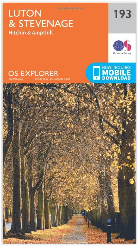
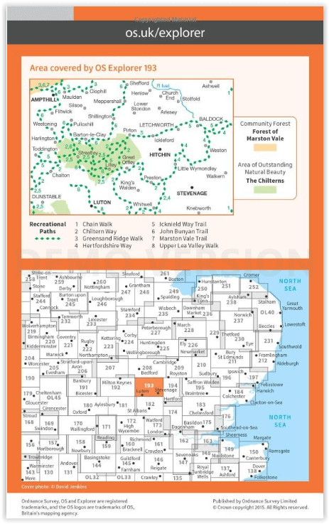
Productomschrijving: Kaart nummer 193 in de OS Explorer kaarten reeks omvat The Chilterns AONB. De Chiltern way, Icknield way Trail en John Bunyan Trail zijn maar enkele van de wandelingen in dit gebied die gaan langs de steden van Luton, Stevenage, Hitchin en Ampthill. De OS Explorer kaart voor Luton & Stevenage is beschikbaar in zowel de standaard papieren versie als de weerbestendige 'Actief' versie.
Kaart nummer 193 is een all purpose kaart vol gepakt met informatie om u het gebied te helpen leren kennen. De 204 Landranger-kaarten bestrijken het land. Elke kaart heeft een oppervlakte van 40 km door 40 km (25 mijl door 25 mijl) en zoals andere kaarten van Ordnance Survey, National Grid-vierkanten worden verstrekt zodat elke functie een unieke referentienummer kan worden gegeven.
Productdiscription: Map sheet number 193 in the OS Explorer series includes The Chilterns, an Area of Outstanding Natural Beauty. The Chiltern Way, Icknield Way Trail and John Bunyan Trail are some of the walks in this area that go past the towns of Luton, Stevenage, Hitchin and Ampthill. The OS Explorer map for Luton & Stevenage is available in both the standard paper version and weatherproof 'Active' version.
Locatie op kaart
Gekoppelde artikelen

Wandelkaart 193 Luton & Stevenage- Bedfordshire - OSI • 9780319243862
standaard versieWandelkaart Luton & Stevenage - Bedfordshire England Omvat ook: Hitchin & Ampthill Productomschrijving: Kaart nummer 193 in de OS Explorer kaarten reeks omvat The Chilterns AONB. De Chiltern way, Icknield way Trail en John Bunyan Trail zijn maar enkele van de wandelingen in dit gebied die gaan langs de steden van Luton, Stevenage, Hitchin en Ampthill. De OS Explorer kaart voor Luton & …

Wandelkaart 193 Luton & Stevenage & Hitchin - OSI • 9780319470657
weatherproof versieWandelkaart Luton & Stevenage - Hitchin & Ampthill E. England Productbeschrijving: Kaart nummer 193 in de OS Explorer kaarten reeks omvat The Chilterns AONB, een Area of Outstanding Natural Beauty AONB. De Chiltern Way, Icknield Way Trail en John Bunyan Trail zijn enkele van de wandelingen in dit gebied die gaan langs de steden van Luton, Stevenage, Hitchin en Ampthill. De OS Explorer kaar…
Overzichtskaarten

OSI Explorer & Explorer Active - Midden Engeland - Midlands
OSI Explorer & Explorer Active - Midden Engeland - Midlands

Producten op de overzichtskaart
Klik op een product om naar de detailpagina te gaan.
- Wandelkaart 179 Gloucester- Cheltenham & Stroud - OSI
- Wandelkaart 180 Oxford- England - OSI
- Wandelkaart 181 Chiltern Hills North AONB- Wycombe - OSI
- Wandelkaart 182 St-Albans & Hatfield- Hertfordshire - OSI
- Wandelkaart 189 Hereford & Ross-on-Wye- England - OSI
- Wandelkaart 190 Malvern Hills AONB & Bredon Hill - OSI
- Wandelkaart 191 Banbury- Bicester & Chipping Norton- OSI
- Wandelkaart 192 Buckingham & Milton Keynes - OSI
- Wandelkaart 193 Luton & Stevenage- Bedfordshire - OSI
- Wandelkaart 194 Hertford & Bishop's Stortford - OSI
- Wandelkaart 202 Leominster & Bromyard Hererfordshire - OSI
- Wandelkaart 203 Ludlow & Shropshire Hills AONB - OSI
- Wandelkaart 204 Worcester & Droitwich Spa - OSI
- Wandelkaart 205 Stratford-upon-Avon & Evesham - OSI
- Wandelkaart 206 Edge Hill & Fenny Compton - OSI
- Wandelkaart 207 Newport Pagnell & Northampton - OSI
- Wandelkaart 208 Bedford & St Neots- Bedforeshire - OSI
- Wandelkaart 209 Cambridge - England - OSI
- Wandelkaart 217 Long Mynd & Wenlock Edge - OSI
- Wandelkaart 218 Kidderminster & Wyre Forest - OSI
- Wandelkaart 219 Wolverhampton & Dudley - OSI
- Wandelkaart 220 Birmingham- West Midlands - OSI
- Wandelkaart 221 Coventry & Warwickshire - OSI
- Wandelkaart 222 Rugby & Daventry- Warwickshire - OSI
- Wandelkaart 223 Northampton & Market Harborough - OSI
- Wandelkaart 224 Corby- Kettering & Wellingborough - OSI
- Wandelkaart 225 Huntingdon & St Ives - OSI
- Wandelkaart 227 Peterborough- Cambridgeshire England - OSI
- Wandelkaart 228 March- Ely- Chatteris & Littleport - OSI
- Wandelkaart 232 Nuneaton & Tamworth- Warwickshire - OSI
- Wandelkaart 233 Leicester & Hinckley England - OSI
- Wandelkaart 234 Rutland Water & Stamford- Oakham - OSI
- Wandelkaart 235 Wisbech & Peterborough North - OSI
- Wandelkaart 241 Shrewsbury- shropshire England - OSI
- Wandelkaart 242 Telford- Ironbridge & the Wrekin - OSI
- Wandelkaart 243 Market Drayton- Schropshire - OSI
- Wandelkaart 244 Cannock Chase & Chasewater- Severn - OSI
- Wandelkaart 245 National Forest- Burton-upon-Trent - OSI
- Wandelkaart 245 National Forest - OSI
- Wandelkaart 246 Loughborough- Leicestershire England - OSI
- Wandelkaart 247 Grantham- Lincolnshire - OSI
- Wandelkaart 248 Bourne & Heckington- lincolnshire - OSI
- Wandelkaart 249 Spalding & Holbeach- Lincolnshire - OSI
- Wandelkaart 257 Crewe & Nantwich & Cheshire East - OSI
- Wandelkaart 258 Stoke-on-Trent & Newcastle-under-Lyme- OSI
- Wandelkaart 259 Derby & Utoxeter- Derbyshire - OSI
- Wandelkaart 260 Nottingham & Vale of Belvoir - OSI
- Wandelkaart 261 Boston & Lincolnshire- England - OSI
- Wandelkaart 267 Northwich & Delamere Forest - OSI
- Wandelkaart 268 Wilmslow- Macclesfield & Congleton - OSI
- Wandelkaart 269 Chesterfield & Alfreton- Derbyshire- OSI
- Wandelkaart 270 Sherwood Forest- Nottinghamshire - OSI
- Wandelkaart 271 Newark-on-Trent- Nottinghampshire - OSI
- Wandelkaart 272 Lincoln- England - OSI
- Wandelkaart 273 Lincolnshire Wolds South- England - OSI
- Wandelkaart 274 Skegness- Alford & Spilsby - OSI
- Wandelkaart 275 Liverpool- South West England - OSI
- Wandelkaart 276 Bolton- Wigan & Warrington- Machester - OSI
- Wandelkaart 277 Manchester & Salford - OSI
- Wandelkaart 278 Sheffield & Barnsley- South Yorkshire - OSI
- Wandelkaart 279 Doncaster- South Yorkshire - OSI
- Wandelkaart 280 Isle of Axholme- Lincolnshire - OSI
- Wandelkaart 281 Ancholme Valley- Lincolnshire - OSI
- Wandelkaart 282 Lincolnshire Wolds North- England - OSI
- Wandelkaart 283 Louth & Mablethorpe- Lincolnshire - OSI
- Wandelkaart 284 Grimsby- Cleethorpes & Immingham - OSI
Artikelen uit dezelfde regio

Wandelkaart 153 Bedford & Huntingdon- England - OSI • 9780319474761
Wandelkaart Bedford & Huntingdon - Bedfordshire England Productbeschrijving: De oude steden van Bedford, Huntingdon en St Neots liggen allemaal aan de oevers van de Great Ouse - die op deze OS Landranger 153 kaart verschijnen. De belangrijkste bezienswaardigheden van Bedford omvatten St Paul's Church en Bedford Park. Huntingdon, als geboorteplaats van Oliver Cromwell is een historische sta…

Wandelkaart 166 Luton- Hertford & Hitchin - OSI • 9780319262641
Wandelkaart Luton Hertford & Hitchin - England Productbeschrijving: Het platteland van de Hertfordshire word gedekt door OS Landranger kaart 166, ideaal voor wandel- en fietsroute enthousiastelingen - en met goede reden. Er zijn hier heelm veel wandel- of fietsroutes, zoals bijvoorbeeld de "Cole Green way" na de oude spoorweg van Hertford aan de unieke Welwyn Garden City. De OS Landran…

Wandelkaart 172 Chiltern Hills East AONB- Oxfordshire- OSI • 9780319470442
Wandelkaart Chiltern Hills East AONB - Oxfordshire England Omvat ook: High Wycombe, Maidenhead & Rickmansworth. Productbeschrijving: Kaart nummer 172 in de OS Explorer kaarten reeks omvat High Wycombe, Maidenhead, Rickmansworth, Gerrards Cross, Northwood, Slough, Uxbridge, Hillingdon, Amersham, Chorleywood, Ruislip en Marlow, de oostelijke Chiltern Hills AONB en het pad van de Thames. …

Wandelkaart 208 Bedford & St Neots- Sandy - OSI • 9780319470800
Wandelkaart Bedford & St Neots- Sandy- Bedfordshire Omvat ook: Sandy & Biggleswade. Productbeschrijving: OS Explorer kaart 208 toont de steden van Bedford, St Neots, Sandy en Biggleswade. Andere hoogtepunten zijn de Forest van Marston Vale, de Greensand Ridge Walk, John Bunyan trail en de Ouse Valley way. De OS Explorer kaart voor Bedford & St Neots is beschikbaar in zowel de standaard…

Wandelkaart 181 Chiltern Hills AONB North- England - OSI • 9780319470534
Wandelkaart Chiltern Hills AONB North - Oxfordshire Omvat ook: Aylesbury, Berkhamsted & Chesham. Productbeschrijving: Kaart nummer 181 in de OS Explorer reeks omvat Aylesbury, Wendover, Berkhamstead, Chesham, Princes Risborough en Tring. Hoogtepunten van het gebied zijn The Chiltern Hills, rivier Thame, The Chilterns AONB, Aylesbury Ring, de Ridgeway en de Chiltern way. De OS Explorer …