
Wandelkaart 224 Corby Kettering & Wellingborough - OSI
Omvat Corby- Kettering en Wellingborough
Korte omschrijving
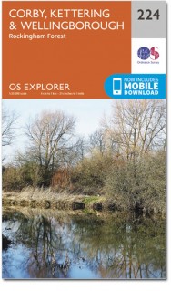
Wandelkaart Corby- Kettering & Wellingborough - Northamptonshire Omvat ook: Rockingham Forest. 224 / Corby, Kettering & Wellingborough, Northamptonshire, England - OS Explorer kaart 224 ...

Specificaties
- Uitgever: Ordnance Survey
- ISBN-13: 9780319244173
- HOOFDCATEGORIEËN: Wandelkaart
- Activiteiten: Wandelen, Hiking & Trekking
- Regio: Northamptonshire, Engeland
- Land: England
- Schaal: 1:25000
- Afmeting: 13x23
- Taal: Engels
- Reeks: Explorer Series
Volledige omschrijving
Wandelkaart Corby- Kettering & Wellingborough - Northamptonshire
Omvat ook: Rockingham Forest.
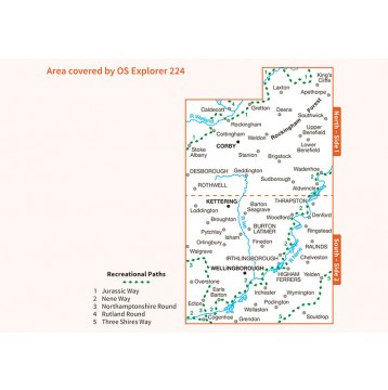
224 / Corby, Kettering & Wellingborough, Northamptonshire, England - OS Explorer kaart 224 omvat Corby, Kettering en Wellingborough, met inbegrip van de rivier de Nene en het Nene way recreatief pad. Er zijn een aantal belangrijke historische gebouwen, waarvan sommige open zijn voor het publiek. Er is ook het Rockingham bos die een scala aan activiteiten, met name voor kinderen. De OS Explorer kaart voor Corby, Kettering & Wellingborough is beschikbaar in zowel de standaard papieren versie als de weerbestendige 'Actief' versie.
224 / Corby, Kettering & Wellingborough, Northamptonshire, England - OS Explorer Map 224 shows Corby, Kettering and Wellingborough, including River Nene and the Nene Way Recreational Path. There are a number of important historical buildings, some of which are open to the public. There is also the Rockingham Forest which offers a range of activities, especially for children. The OS Explorer map for Corby, Kettering & Wellingborough is available in both the standard paper version and weatherproof 'Active' version.
Locatie op kaart
Gekoppelde artikelen

Wandelkaart 224 Corby Kettering & Wellingborough - OSI • 9780319244173
standaard versieWandelkaart Corby- Kettering & Wellingborough - Northamptonshire Omvat ook: Rockingham Forest. 224 / Corby, Kettering & Wellingborough, Northamptonshire, England - OS Explorer kaart 224 omvat Corby, Kettering en Wellingborough, met inbegrip van de rivier de Nene en het Nene way recreatief pad. Er zijn een aantal belangrijke historische gebouwen, waarvan sommige open zijn voor het publi…

Wandelkaart 224 Corby Kettering & Wellingborough - OSI • 9780319470961
weatherproof versieWandelkaart Corby- Kettering & Wellingborough - Northamptonshire Omvat ook: Rockingham Forest. Productbeschrijving: De OS Explorer kaart 224 omvat Corby, Kettering en Wellingborough, met inbegrip van de rivier de Nene en de Nene way recreatief pad. Er zijn een aantal belangrijke historische gebouwen, waarvan sommige open voor het publiek. Er is ook het Rockingham bos die een scala aan …
Overzichtskaarten

OSI Explorer & Explorer Active - Midden Engeland - Midlands
OSI Explorer & Explorer Active - Midden Engeland - Midlands

Producten op de overzichtskaart
Klik op een product om naar de detailpagina te gaan.
- Wandelkaart 179 Gloucester- Cheltenham & Stroud - OSI
- Wandelkaart 180 Oxford- England - OSI
- Wandelkaart 181 Chiltern Hills North AONB- Wycombe - OSI
- Wandelkaart 182 St-Albans & Hatfield- Hertfordshire - OSI
- Wandelkaart 189 Hereford & Ross-on-Wye- England - OSI
- Wandelkaart 190 Malvern Hills AONB & Bredon Hill - OSI
- Wandelkaart 191 Banbury- Bicester & Chipping Norton- OSI
- Wandelkaart 192 Buckingham & Milton Keynes - OSI
- Wandelkaart 193 Luton & Stevenage- Bedfordshire - OSI
- Wandelkaart 194 Hertford & Bishop's Stortford - OSI
- Wandelkaart 202 Leominster & Bromyard Hererfordshire - OSI
- Wandelkaart 203 Ludlow & Shropshire Hills AONB - OSI
- Wandelkaart 204 Worcester & Droitwich Spa - OSI
- Wandelkaart 205 Stratford-upon-Avon & Evesham - OSI
- Wandelkaart 206 Edge Hill & Fenny Compton - OSI
- Wandelkaart 207 Newport Pagnell & Northampton - OSI
- Wandelkaart 208 Bedford & St Neots- Bedforeshire - OSI
- Wandelkaart 209 Cambridge - England - OSI
- Wandelkaart 217 Long Mynd & Wenlock Edge - OSI
- Wandelkaart 218 Kidderminster & Wyre Forest - OSI
- Wandelkaart 219 Wolverhampton & Dudley - OSI
- Wandelkaart 220 Birmingham- West Midlands - OSI
- Wandelkaart 221 Coventry & Warwickshire - OSI
- Wandelkaart 222 Rugby & Daventry- Warwickshire - OSI
- Wandelkaart 223 Northampton & Market Harborough - OSI
- Wandelkaart 224 Corby- Kettering & Wellingborough - OSI
- Wandelkaart 225 Huntingdon & St Ives - OSI
- Wandelkaart 227 Peterborough- Cambridgeshire England - OSI
- Wandelkaart 228 March- Ely- Chatteris & Littleport - OSI
- Wandelkaart 232 Nuneaton & Tamworth- Warwickshire - OSI
- Wandelkaart 233 Leicester & Hinckley England - OSI
- Wandelkaart 234 Rutland Water & Stamford- Oakham - OSI
- Wandelkaart 235 Wisbech & Peterborough North - OSI
- Wandelkaart 241 Shrewsbury- shropshire England - OSI
- Wandelkaart 242 Telford- Ironbridge & the Wrekin - OSI
- Wandelkaart 243 Market Drayton- Schropshire - OSI
- Wandelkaart 244 Cannock Chase & Chasewater- Severn - OSI
- Wandelkaart 245 National Forest- Burton-upon-Trent - OSI
- Wandelkaart 245 National Forest - OSI
- Wandelkaart 246 Loughborough- Leicestershire England - OSI
- Wandelkaart 247 Grantham- Lincolnshire - OSI
- Wandelkaart 248 Bourne & Heckington- lincolnshire - OSI
- Wandelkaart 249 Spalding & Holbeach- Lincolnshire - OSI
- Wandelkaart 257 Crewe & Nantwich & Cheshire East - OSI
- Wandelkaart 258 Stoke-on-Trent & Newcastle-under-Lyme- OSI
- Wandelkaart 259 Derby & Utoxeter- Derbyshire - OSI
- Wandelkaart 260 Nottingham & Vale of Belvoir - OSI
- Wandelkaart 261 Boston & Lincolnshire- England - OSI
- Wandelkaart 267 Northwich & Delamere Forest - OSI
- Wandelkaart 268 Wilmslow- Macclesfield & Congleton - OSI
- Wandelkaart 269 Chesterfield & Alfreton- Derbyshire- OSI
- Wandelkaart 270 Sherwood Forest- Nottinghamshire - OSI
- Wandelkaart 271 Newark-on-Trent- Nottinghampshire - OSI
- Wandelkaart 272 Lincoln- England - OSI
- Wandelkaart 273 Lincolnshire Wolds South- England - OSI
- Wandelkaart 274 Skegness- Alford & Spilsby - OSI
- Wandelkaart 275 Liverpool- South West England - OSI
- Wandelkaart 276 Bolton- Wigan & Warrington- Machester - OSI
- Wandelkaart 277 Manchester & Salford - OSI
- Wandelkaart 278 Sheffield & Barnsley- South Yorkshire - OSI
- Wandelkaart 279 Doncaster- South Yorkshire - OSI
- Wandelkaart 280 Isle of Axholme- Lincolnshire - OSI
- Wandelkaart 281 Ancholme Valley- Lincolnshire - OSI
- Wandelkaart 282 Lincolnshire Wolds North- England - OSI
- Wandelkaart 283 Louth & Mablethorpe- Lincolnshire - OSI
- Wandelkaart 284 Grimsby- Cleethorpes & Immingham - OSI
Artikelen uit dezelfde regio

Wandelkaart 141 Kettering & Corby England - OSI • 9780319262399
Wandelkaart Kettering & Corby - England - OSI Productbeschrijving: OS Landranger kaart 141 omvat Kettering en Corby, als ook Market Harborough, Stamford, Raunds, Rushton, Oundle, Medbourne, Atherstone, John O'Gaunt, Eyebrook Reservoir, Rutland Water en een klein deel van de Europese lange afstand pad van E2. De OS Landranger kaarten reeks heeft betrekking op Groot-Brittannië met 204 ge…

Wandelkaart 223 Northampton & Market Harborough - OSI • 9780319470954
Wandelkaart Northampton & Market Harborough - England Omvat ook: Brixworth & Pitsford Water. Productbeschrijving: OS Explorer kaart 233 toont Northampton, Market Harborough en Pitsford Water en heeft talloze recreatieve paden, alsmede kleinere wandelpaden en wandelingen. Deze omvatten Brampton Valley Way, Jurassic Way, Macmillan Way, Nene Way en Leicestershire Round. Pitsford waterrese…

Wandelkaart 140 Kettering & Corby- England - OSI • 9780319474648
Wandelkaart Kettering & Corby - Northamptonshire England Productbeschrijving: Kaart OS Landranger 141 dekt Kettering & Corby, en omvat ook Market Harborough, Stamford, Raunds, Rushton, Oundle, Medbourne, Atherstone, John O'Gaunt, Eyebrook Reservoir, Rutland Water en een klein deel van de Europese lange afstand pad van E2. De OS Landranger kaarten reeks heeft betrekking op Groot-Brittannië…