
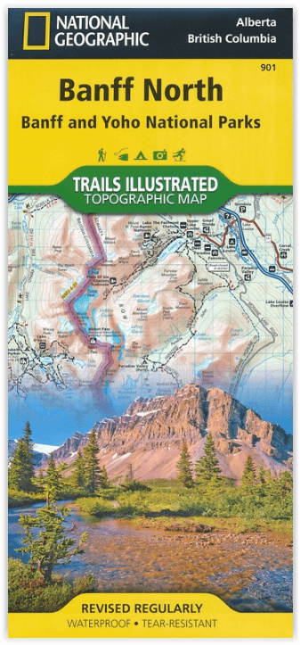
Wandelkaart 901 Banff North - Banff and Yoho NP - Nat Geo
Topografische wandelkaart van 2 van Canada's nationale parken
Korte omschrijving
TOPO Wandelkaart 901 - Banff North - Banff and Yoho NP - Natgeo Productomschrijving: Deze topografische wandelkaart van 2 van Canada's mooiste nationale parken heeft heel wat in petto. De ka...

Specificaties
- Uitgever: National Geographic
- ISBN-13: 9781566956598
- HOOFDCATEGORIEËN: Wandelkaart
- Regio: Alberta, Canada
- Land: Canada
- Nationale parken: Banff NP Alberta Canada, Yoho NP, Alberta, Canada
- Schaal: 1:100000
- Afmeting: 10x19
- Taal: Engels
Volledige omschrijving
TOPO Wandelkaart 901 - Banff North - Banff and Yoho NP - Natgeo
Productomschrijving: Deze topografische wandelkaart van 2 van Canada's mooiste nationale parken heeft heel wat in petto. De kaart is meer dan voldoende voor deze 2 zeer grote weliswaar wilde plaatsen. Wat er ook te vinden valt is bijvoorbeeld het beeldschone Lake Louis, die te vinden is langs de grote en enige autoroute door dit stukje nationaal park, die dan ook verder loopt in de richting van Jasper NP.
Engelse omschrijving: National Geographic's Trails Illustrated map of Banff North delivers unmatched detail for outdoor enthusiasts exploring the unparalleled mountain scenery and abundance of recreational opportunities of the Canadian Rockies. Expertly researched and created in cooperation with Parks Canada and others, the map covers the northern and western areas of Banff National Park as well as Yoho and Kootenay National Parks, Siffleur and White Goat Wilderness Areas, Kootenay Plains Provincial Park and the southeastern tip of Jasper National Park. Many popular recreation points of interest are shown, including Lakes Louise and O'Hara as well as the scenic Icefields Parkway, displayed with distance markers.
Explore the area by following the map to trailheads and then along precisely mapped trails, shown with distance markers in miles and kilometers and labeled for hiking, biking and horseback riding. To aid in your navigation the map shows glaciers and icefields, contour lines and elevations, labeled peaks and passes, areas of rock debris and water features. Find suitable areas for exploration, according to your area of interest, with labeled campgrounds and campsites, backcountry lodging and cabins, horse camps and corrals, biking and skiing areas, river access points, fishing areas, lookout towers and scenic viewpoints. The map also includes background information about the area, bear safety tips and essential contact information.
Every Trails Illustrated map is printed on "Backcountry Tough" waterproof, tear-resistant paper. A full UTM grid is printed on the map to aid with GPS navigation. Other features found on this map include: Banff National Park, Lake Louise.
.png)
Locatie op kaart
Overzichtskaarten

NAT GEO Jasper Alberta trail map
NAT GEO Jasper Alberta trail map

Producten op de overzichtskaart
Klik op een product om naar de detailpagina te gaan.
Artikelen uit dezelfde regio
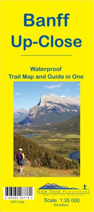
Wandelkaart 11 Banff Up-Close - Gemtrek • 9781895526776
Wandelkaart - Banff Up-Close - Gemtrek Productomschrijving: Banff, een begrip in Alberta en wereldwijd, als skigebied en als wandelgebied in de zomermaanden. Banff heeft maar een klein stukje dat echt kan worden betreden als skigebied, de meerderheid van de skiërs gaan in de richting van Lake Louis zo'n 35km verder richting Jasper National park, die zelf zo'n 400km van Banff ligt. In Banff…

Wandelgids Toptrails - Nordamerika West - Rother • 9783763331857
Toptrails - Nordamerika West - Rother Productomschrijving: De uitgestrekte gebieden van het Amerikaanse Westen herbergen een grote verscheidenheid aan buitengewone natuurlandschappen. De bekendste werden al vroeg beschermd als de eerste nationale parken op aarde. Uitstekend ontwikkelde bezoekersfaciliteiten maken de spectaculaire bergen, kusten en woestijnen gemakkelijk toegankelijk voor i…

Wandelkaart 13 Het beste van Lake Louise - Gemtrek • 9781895526752
Wandelkaart - Het beste van Lake Louise - Gemtrek Productomschrijving: Lake Louis, het befaamde meer, die althans de naam meedraagt. We spreken uiteraard over een volledig gebied. De Lake zelf is een prachtig helderblauw watergebied, met een immens uitzicht op de bijgelegen hoge met sneeuwbedekte bergen. In de winter kan tot een meter sneeuw op het water liggen, in de zomer vallen de blade…

Reisgids Banff- Jasper & Glacier NP - Lonely Planet • 9781786575920
Banff- Jasper & Glacier NP - Lonely Planet Covers: Banff National Park, Jasper National Park, Glacier National Park, Lake Louise, Lake Minnewanka, Bow Valley, Backcountry, Kananaskis Country, Lake O’Hara, Jasper Town, Blackfeet Indian Reservation and more. Product description: Lonely Planet Banff, Jasper & Glacier National Parks is your passport to the most relevant, up-to-date advice …

Wandelkaart D50 - Canadian Rockies - Gem Trek • 9781895526929
Wandelkaart Canadian Rockies - Gem Trek Productomschrijving: De Canadian Rockies Map is onze populairste kaart, en een must-have voor iedereen die een reis plant naar de Banff, Jasper, Yoho of Kootenay National Parks. Om het bekijken van de bezienswaardigheden te vergemakkelijken, zijn 29 van de beste bezienswaardigheden in de parken genummerd en beschreven. Om u te helpen uw weg te vi…