
Fietsgids Cycling The North Coast 500 - Cicerone
Durness - John o' Groats - The far north of Scotland - 850 km
Korte omschrijving
Cycling The North Coast 500 - Cicerone Productomschrijving: Het verre noorden van Schotland, biedt met deze nieuwe fietsgids een wervelende route rond het schiereiland van om en bij de 850 k...

Specificaties
- Uitgever: CICERONE Press
- ISBN-13: 9781786312198
- HOOFDCATEGORIEËN: Fietsgids
- Activiteiten: Fietsen / VTT / MTB
- Auteur: Mike Wells
- Regio: Northern Highland's, Schotland, Schotland
- Land: Schotland
- Blz.: 208
- Afmeting: 12x17
- Editie: 2
- Taal: Engels
Volledige omschrijving
Cycling The North Coast 500 - Cicerone
Productomschrijving: Het verre noorden van Schotland, biedt met deze nieuwe fietsgids een wervelende route rond het schiereiland van om en bij de 850 km fietsplezier, of 528 miles. De route brengt u langs Wester Ross, Sutherland, Caithness, Easter Ross & the Black Isle.
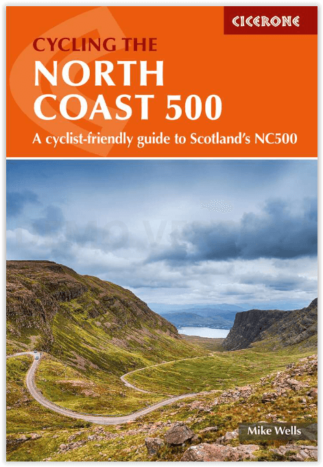
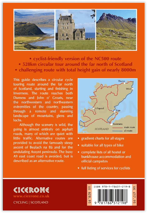
Engelse omschrijving: This guidebook describes a 528-mile cycling route in northern Scotland. Starting and finishing in the highland capital Inverness, the circular route passes through the ancient counties and districts of Wester Ross, Sutherland, Caithness, Easter Ross and the Black Isle and is suitable for mountain, touring and road bikes: the going is entirely on asphalt-surfaced roads, though many are quiet with little traffic. The circuit can be comfortably completed in a fortnight.
Featuring clear and concise route description, together with 1:150,000 mapping, gradient profiles, suggested schedules and invaluable practical information - including complete lists of all hostel/bunkhouse accommodation, official campsites and services for cyclists and advice on other accommodation and refreshment opportunities, this guidebook provides all the information needed to plan and execute a terrific cycle tour. Alternative routes are provided in case you should wish to avoid the steep ascent of Bealach na Bà or the undulating Assynt peninsula, or to include the busier A9 east coast road.
The route boasts stunning scenery and rich historical interest and cyclists will be treated to mile upon mile of unspoilt wilderness. The journey takes in varied landscapes of craggy mountains, verdant glens, rolling peat moorland dotted with lochs and wild rugged coastlines - and if the scenery isn't enough, there are many distilleries and micro-breweries on or near the route guaranteed to entice. With notes on history, geology, wildlife and local points of interest, the guide offers a perfect way to get to know Scotland's captivating far north.
Seasons:
Best cycled between May and September
Centres:
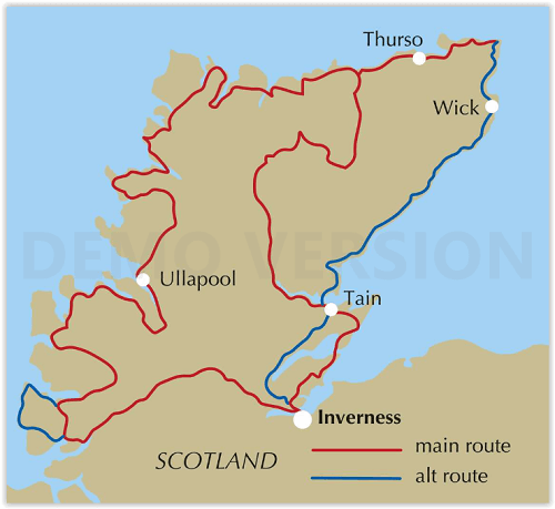
A circular ride starting and ending in the highland capital Inverness. Small towns are passed at Ullapool, Thurso and Tain
Difficulty:
A challenging cycle route due to frequent undulations, with ascent totalling nearly 8000m. Climbs vary from steady climbs over low mountain passes to short steep hills. The road surface is asphalt throughout, presenting no problem. Suitable for all types of bike with a wide range of gears and appropriate tyres. Lights and high-vis jackets essential due to the possibility of misty conditions on narrow roads.
Must See:
The beautiful and varied landscapes of the far north of Scotland. Major mountains are passed at Torridon, An Teallach and in Assynt. The route reaches both Durness and John o' Groats, near to the northwestern and northeastern extremities of Scotland.

Artikelen uit dezelfde regio

Wandelkaart Cape Wrath Durness Schotland - Harvey maps • 9781851375349
Wandelkaart - Cape Wrath Durness Schotland - Harvey maps Productomschrijving: De Cape Wrath Trail is een uitdagende route van Fort William naar Cape Wrath. Hij is ongeveer 200 mijl lang en stroomt door enkele van de wildste en meest spectaculaire landschappen van Schotland. Deze kaart heeft betrekking op het zuidelijke deel van de route, vanaf Strathcarron naar Cape Wrath. De trail is …

Reisgids Great Britain - DK Eyewitness • 9780241408292
Reisgids Great Britain - DK Eyewitness Productomschrijving: Visit Stonehenge's mysterious monoliths, take the sea air in buzzing Brighton or come face to face with the Vikings in York: everything you need to know is clearly laid out within colour-coded chapters. Discover the best of Great Britain with this indispensable travel guide. Inside DK Eyewitness Travel Guide Great Britain: -…

Wandelgids Great Britain best day walks - Lonely Planet • 9781838690786
Great Britain best day walks van Lonely Planet Productomschrijving: Best Day Walks Great Britain van Lonely Planet is uw paspoort voor 60 eenvoudige ontsnappingen in de natuur. Strek uw benen buiten de stad door een wandeling te kiezen die bij u past, van een paar uur tot een hele dag, van gemakkelijk tot zwaar. Doorkruis mistige heidevelden, wandel door wilde landschappen en verken de hoo…

Wandelgids John o' Groats Trail - Cicerone • 9781786310576
John o' Groats Trail - Cicerone Press Productomschrijving: Gids voor de John O' Groats Trail, een 235 km langeafstandswandeling van Inverness naar John O' Groats in het uiterste noorden van Schotland. Het pad biedt een prachtig kustlandschap en fantastische wandelingen op de klippen, terwijl aantrekkelijke steden en dorpen accommodatie bieden. De tocht kan in ongeveer veertien dagen worden…

Wandelkaart Suilven - Northern Highlands XT40 ultra - Harvey maps • 9781851376483
Wandelkaart Suilven - Northern Highlands - Harvey maps Productomschrijving: De kaart omvat een groot gebied, en is een praktisch en compact zakformaat. Dit is een fantastisch en mooi gebied, met Suilven centraal. De kaart bevat de twee Munros van Ben More Assynt en Conival, alsook andere bekende bergen zoals Cul Mor, Cul Beag, Canisp en Stac Pollaidh. De kaart bedekt het gebied naar het no…