
Fietsgids Source Massif Central to Atlantic Coast - Cicerone
1052 km - En deel van EuroVélo 6
Korte omschrijving
Fietsgids Source Massif Central to Atlantic Coast - Cicerone Press Productomschrijving: De gloednieuwe fietsgids voor het fietsen van de Loire, de langste rivier van Frankrijk, vanaf de bron...

Specificaties
- Uitgever: CICERONE Press
- ISBN-13: 9781786310835
- HOOFDCATEGORIEËN: Fietsgids
- Activiteiten: Fietsen / VTT / MTB
- Auteur: Mike Wells
- Regio: Pays-de-la-Loire, Frankrijk
- Land: Frankrijk
- Toepasselijke bergketen: Cevennen, Frankrijk centraal massief, Massief Central France
- Blz.: 256
- Afmeting: 12x17
- Editie: 3
- Taal: Engels
Volledige omschrijving
Fietsgids Source Massif Central to Atlantic Coast - Cicerone Press
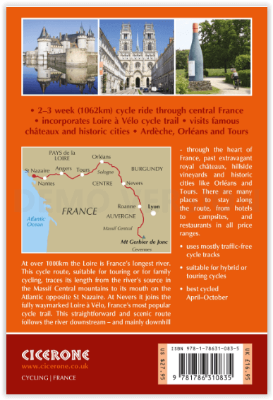
Productomschrijving: De gloednieuwe fietsgids voor het fietsen van de Loire, de langste rivier van Frankrijk, vanaf de bron in het Centraal Massief tot aan de Atlantische Oceaan. De 1052 km lange route omvat een deel van EuroVélo 6 en de populaire, bewegwijzerde Loire à Vélo, langs uitgedoofde vulkanen, wijngaarden en kastelen. Er wordt voornamelijk gefietst over fietspaden en secundaire wegen.
Engelse omschrijving: Guidebook to cycling the Loire, France's longest river, from its source in the Massif Central to the Atlantic. The 1052km (654 mile) route incorporates a section of EuroVélo 6 and the popular, waymarked Loire à Vélo, taking in extinct volcanos, vineyards and châteaux. Cycling is mostly on cycle paths and minor roads.
Seasons:
The whole route can be cycled when the mountains near the source are snow free, usually April-October. Stages 7 to 26 can be cycled at any time of year, though April-October is the best period.
Centres:
A point-to-point route with no particular bases.
Difficulty:
Apart from a steep 1000m climb to reach the start and a few ascents and descents in the first six stages this is a straightforward route that is generally downhill or level. Mostly asphalt surfaces in good condition suitable for hybrid or touring cycles. Much of the route follows dedicated off-road cycle tracks, suitable for family cycling, though there are a few short sections where main roads are used.
Must See:
Mont Gerbier de Jonc and the volcanic hills of the Ardèche, Le Puy-en-Velay, Charollais hills. After Nevers the route follows La Loire à Vélo, France's most popular cycleway, passing many of the royal châteaux (Chambord, Blois, Chaumont, Villandry, Amboise), vineyards (Sancerre, Touraine, Chinon, Saumur, Anjou, Muscadet), and historic cities (Orléans, Tours, Angers, Nantes) of the Loire Valley.

Artikelen uit dezelfde regio

Wandelkaart 1522 ET Angers - IGN • 9782758552055
Wandelkaart Angers - IGN Productomschrijving: Angers, in het westen van Frankrijk, ligt in het departement Maine-et-Loire, 300 km ten zuidwesten van Parijs, en is de hoofdstad van het departement. Het gebied rond Angers staat bekend onder de naam Anjou. Omvat: Angers, Béhuard, Saint-Léger-de-Linières, Loire-Authion, Rochefort-sur-Loire, Trélazé, Verrières-en-Anjou, Avrillé, Denée, Sav…

Wandelkaart 1423 SB Chemillé & Beaupréau - IGN • 9782758539360
Wandelkaart 1423 SB - Chemillé & Beaupréau Productomschrijving: Chemillé is een plaats en voormalige gemeente in het Franse departement Maine-et-Loire in de regio Pays de la Loire. De plaats maakt deel uit van het arrondissement Cholet. Desciptive produits: Une nouvelle cartographie pour une lisibilité optimale, avec une meilleure précision géométrique et des informations touristiques …

Wandelkaart 1522 ET Angers France - IGN • 9782758539414
TOPO Wandelkaart Angers France - IGN Productomschrijving: Angers is een stad in het westen van Frankrijk in het departement Maine-et-Loire, ongeveer 300 km ten zuidwesten van Parijs. Angers is de hoofdstad van het departement. Het gebied rond Angers staat bekend onder de provinciale naam Anjou. Descriptif complet: Ces cartes topographiques d'une très grande précision contiennent tous l…

Wandelkaart 1719 SB Le Mans & La Suze-sur-Sarthe - IGN • 9782758533863
Wandelkaart 1719 SB - Le Mans & La Suze-sur-Sarthe Productomschrijving: Deze topografische kaarten hebben een zeer nauwkeurige gronddetail, niet te vergeten de topografische hoogteprofielen, die het wandelen een stuk gemakkelijker maken. La Suze-sur-Sarthe is een gemeente in het Franse departement Sarthe (regio Pays de la Loire) en telt 3597 inwoners (1999). De plaats maakt deel uit van h…

Wandelgids Maine-et-Loire - 30 balades à pied - Chamina • 9782844664563
Wandelgids - Maine-et-Loire - 30 balades à pied - Chamina Productomschrijving: 30 van de mooiste wandelroutes in het departement van Maine-et-Loire, in de echte Loire vallei, en dat allemaal verzameld in een enkele wandelgids. ZO kun u inbder meer te voet het historische grondgebied van Anjou af bewandelen, waarvan een deel wordt beschermd door het Regionaal Natuurpark Loire-Anjou-Touraine…