
Wandelgids - GR10 Trail through the French Pyrenees - Cicerone
Le Sentier des Pyrénées- 955km lange tocht door de Pyreneeën
Korte omschrijving
Wandelgids - GR10 Trail through the French Pyrenees - Cicerone Productomschrijving: Wandelgids over de GR10, "Le Sentier des Pyrénées", een 955km lange tocht door de Franse Pyreneeën van He...

Stockactie
Specificaties
- Uitgever: CICERONE Press
- ISBN-13: 9781852847739
- HOOFDCATEGORIEËN: Wandelgids
- Activiteiten: Wandelen, Hiking & Trekking
- Regio: Occitanië, Frankrijk
- Land: Frankrijk
- Departement: Pyrénées-Orientales (66)
- Blz.: 320
- Afmeting: 12x17
- Editie: 1
- Taal: Engels
Volledige omschrijving
Wandelgids - GR10 Trail through the French Pyrenees - Cicerone
Productomschrijving: Wandelgids over de GR10, "Le Sentier des Pyrénées", een 955km lange tocht door de Franse Pyreneeën van Hendaye aan de Atlantische kust tot de Middellandse Zeekust in Banyuls-sur-Mer. Het boek beschrijft 55 etappes, met informatie over planning, vervoer, accommodatie en faciliteiten. U kunt de hele GR10 in ongeveer 45 dagen of in korter afleggen.
Productdescription: Guidebook to walking the GR10, the Sentier des Pyrénées, a 955km trek across the French Pyrenees from Hendaye on the Atlantic Coast to the Mediterranean coast at Banyuls-sur-Mer. The book describes 55 stages, with information on planning, transport, accommodation and facilities. Walk the entire GR10 in around 45 days or in shorter trips.
Product description: Guidebook to walking the GR10, the Sentier des Pyrénées, a 955km trek across the French Pyrenees from Hendaye on the Atlantic Coast to the Mediterranean coast at Banyuls-sur-Mer. The book describes 55 stages, with information on planning, transport, accommodation and facilities. Walk the entire GR10 in around 45 days or in shorter trips.
Seasons:
Best July to October (June in a low snow year).
Centres:
Hendaye-Plage on the Atlantic coast to Banyuls-sur-Mer on the Mediterranean through the French Pyrenees.
Difficulty:
The GR10 is extremely well waymarked following good mountain paths with short sections of boulderfield and occasional very easy scrambling. It is tough because there is more steep climb and descent than on many long-distance paths. Good network of inexpensive accommodation for those who prefer not to camp. Frequent resupply possible. In early season (May/June) ice-axe and crampons may be required.
Must See:
The GR10 starts with the rolling hills of the Basque country leading to the High Pyrenees including Pic du Midi d'Ossau, Vignemale and Gavarnie. The remote Ariège with Mont Vallier follows and Canigou dominates the approach to the Mediterranean. Wildflower meadows are magnificent throughout.
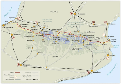
Locatie op kaart
Artikelen uit dezelfde regio

Guide de voyage - Angkor en quelques jours - Lonely Planet • 9783850008440
Fietsgids Canal du Midi - Bikeline Productomschrijving: Langs het werelderfgoed van Toulouse naar de Middellandse Zee - Met Canal de la Robine Heeft u altijd al eens met de fiets door Zuid-Frankrijk willen reizen? En doet u dat liever langs een UNESCO Werelderfgoedlocatie? Dan is een tochtje over het historische Canal du Midi echt iets voor u! Op rustige jaagpaden fietst u langs de oev…

Wandelkaart 2542 OT Camarès & Avène - IGN • 9782758548713
TOPO Wandelkaart Camarès & Avène - IGN Productomschrijving: Camarès & Avène zijn gemeentes in het Franse departement Aveyron in de regio Occitanie. De plaats maakt deel uit van het arrondissement Millau. De TOP 25 kaarten, met nummers die eindigen op "T" hebben betrekking op gebieden van bijzonder toeristisch belang zoals de Alpen, de Pyreneeën, De Cevennes, de Vogezen, de Provence, en…

Wandelkaart 2640OT(R) Gorges du Tarn et de la Jonte • 9782758545422
TOPO Wandelkaart - Gorges du Tarn et de la Jonte Productomschrijving: Gorges du Tarn et de la Jonte & PNR du Causse Méjean is een brede plaat kalksteen in het Franse deel van de Causses. Het is het hoogste plateau van Caussen met een hoogte van 800 m tot 1.247 m op de berg Gargo. De Méjean Causse is volledig opgenomen in de perimeter van de site van Causses en Cévennes, ingeschreven op de…

Wandelkaart 2441 SB - Réquista & Villefranche-de-Panat - IGN • 9782758534297
Wandelkaart - Réquista & Villefranche-de-Panat Productomschrijving: Deze topografische kaarten hebben een zeer nauwkeurige gronddetail, niet te vergeten de topografische hoogteprofielen, die het wandelen een stuk gemakkelijker maken. Réquista is een gemeente in het Franse departement Aveyron (regio Midi-Pyrénées) en telt 2099 inwoners (2004). De plaats maakt deel uit van het arrondissemen…

Wandelgids Gard 30 plus beaux sentiers à pied - Chamina • 9782844666680
Wandelgids Gard, 30 plus beaux sentiers à pied - Chamina Productomschrijving: Een selectie van de mooiste routes in het departement Gard, waaronder: Aigues-Mortes, Le Grau-du-Roi, Nîmes, de Gorges du Gardon, Uzès, de Pont du Gard, Lirac, La Roque-sur-Cèze, het bos van Valbonne, het keteldal van Navacelles, Alès en Aujac. Franse omschrijving: Une sélection des plus beaux itinérair…