
Wandelkaart 216 Welshpool & Montgomery Powys - OSI
Shropshire Hills- Clun Forest & Westbury Churchtown
Korte omschrijving
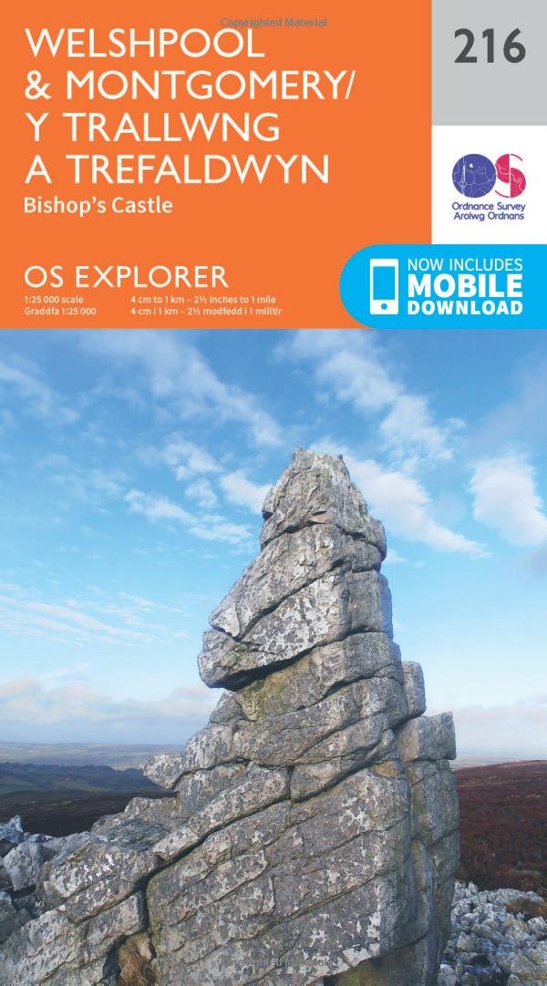
Wandelkaart Welshpool & Montgomery - Powys Wales Omvat ook: Bishop’s Castle. Productbeschrijving: Kaart nummer 216 in de OS Explorer kaarten reeks heeft betrekking op Montgomery (Trefald...

Specificaties
- Uitgever: Ordnance Survey
- ISBN-13: 9780319244098
- HOOFDCATEGORIEËN: Wandelkaart
- Activiteiten: Wandelen, Hiking & Trekking
- Regio: Powys, Wales
- Land: Wales
- Schaal: 1:25000
- Afmeting: 13x23
- Taal: Engels
- Reeks: Explorer Series
Volledige omschrijving
Wandelkaart Welshpool & Montgomery - Powys Wales
Omvat ook: Bishop’s Castle.
Productbeschrijving: Kaart nummer 216 in de OS Explorer kaarten reeks heeft betrekking op Montgomery (Trefaldwyn). Bishop's Castle en Welshpool (Trallwng). Hoogtepunten van het gebied: de Shropshire Hills, de rivier de Severn, Clun Forest, Westbury, Churchtoewn, Argoed en de Stiperstones. Ook ziet u een gedeelte van Offa's Dyke Path en de Glynd'r Way. De OS Explorer kaart voor Welshpool & Montgomery is beschikbaar in zowel de standaard papieren versie als de weerbestendige 'Actief' versie.
Productdiscription: Map sheet number 216 in the OS Explorer series covers Montgomery (Trefaldwyn). Bishop's Castle, and Welshpool (Trallwng). Highlights of the area include: the Shropshire Hills, River Severn, Clun Forest, Westbury, Churchtoewn, Argoed, and the Stiperstones. Also shows part of Offa’s Dyke Path and Glyndwr’s Way. The OS Explorer map for Welshpool & Montgomery is available in both the standard paper version and weatherproof 'Active' version.
Locatie op kaart
Gekoppelde artikelen

Wandelkaart 216 Welshpool & Montgomery Powys - OSI • 9780319244098
standaard versieWandelkaart Welshpool & Montgomery - Powys Wales Omvat ook: Bishop’s Castle. Productbeschrijving: Kaart nummer 216 in de OS Explorer kaarten reeks heeft betrekking op Montgomery (Trefaldwyn). Bishop's Castle en Welshpool (Trallwng). Hoogtepunten van het gebied: de Shropshire Hills, de rivier de Severn, Clun Forest, Westbury, Churchtoewn, Argoed en de Stiperstones. Ook ziet u een gedeel…

Wandelkaart 216 Welshpool & Montgomery - Wales - OSI • 9780319470886
weatherproof versieWandelkaart Welshpool & Montgomery - Powys Wales Omvat ook: Bishop’s Castle. Productbeschrijving: Kaart nummer 216 in de OS Explorer kaarten reeks heeft betrekking op Montgomery (Trefaldwyn). Bishop's Castle en Welshpool (Trallwng). Hoogtepunten van het gebied: de Shropshire Hills AONB, rivier Severn, Clun Forest, Westbury, Churchtoewn, Argoed en de Stiperstones. Ook vind u een gedeelt…
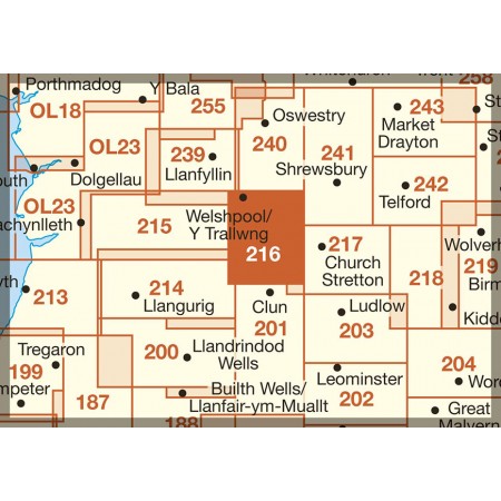
Overzichtskaarten

OSI Explorer & Explorer Active - Wales
OSI Explorer & Explorer Active - Wales

Producten op de overzichtskaart
Klik op een product om naar de detailpagina te gaan.
- Wandelkaart 151 Cardiff & Bridgend- Wales - OSI
- Wandelkaart 152 Newport & Pontypool- South Wales - OSI
- Wandelkaart 164 Gower AONB & Gwyr- South Wales - OSI
- Wandelkaart 165 Swansea & Abertawe- South Wales - OSI
- Wandelkaart 166 Rhondda & Merthyr Tydfil - OSI
- Wandelkaart 177 Carmarthen & Kidwelly- Wales - OSI
- Wandelkaart 178 Llanelli- Ammanford & Rhydaman - OSI
- Wandelkaart 185 Newcastle & Emly- Northumberland - OSI
- Wandelkaart 186 Llandeilo- Brechfa Forest- Wales - OSI
- Wandelkaart 187 Llandovery- South Wales - OSI
- Wandelkaart 188 Builth Wells & Llanfair-ym-Muallt - OSI
- Wandelkaart 189 Hereford & Ross-on-Wye- England - OSI
- Wandelkaart 198 Cardigan & New Quay- Wales - OSI
- Wandelkaart 199 Lampeter- Wales - OSI
- Wandelkaart 200 Llandrindod Wells & Elan Valley - OSI
- Wandelkaart 201 Knighton & Presteigne- Wales - OSI
- Wandelkaart 202 Leominster & Bromyard Hererfordshire - OSI
- Wandelkaart 203 Ludlow & Shropshire Hills AONB - OSI
- Wandelkaart 213 Aberystwyth & Cwm Rheidol - Wales - OSI
- Wandelkaart 214 Llanidloes- Newtown & Y Drenewydd - OSI
- Wandelkaart 215 Newtown & Machynlleth- Powys Wales - OSI
- Wandelkaart 216 Welshpool & Montgomery- Powys - OSI
- Wandelkaart 217 Long Mynd & Wenlock Edge - OSI
- Wandelkaart 239 Lake Vyrnwy & Efyrnwy- North Wales - OSI
- Wandelkaart 240 Oswestry & Croesoswallt- Shropshir - OSI
- Wandelkaart 241 Shrewsbury- shropshire England - OSI
- Wandelkaart 253 Lleyn Peninsula West Wales - OSI
- Wandelkaart 254 Lleyn Peninsula East- Wales - OSI
- Wandelkaart 255 Llangollen & Berwyn- West Wales - OSI
- Wandelkaart 256 Wrexham- Wrecsam & Llangollen - OSI
- Wandelkaart 257 Crewe & Nantwich & Cheshire East - OSI
- Wandelkaart 262 Anglesey West- Wales AONB - OSI
- Wandelkaart 263 Anglesey East AONB- Wales - OSI
- Wandelkaart 264 Vale of Clwyd & Dyffryn Clwyd - OSI
- Wandelkaart 265 Clwydian Range & Bryniau Clwyd - OSI
- Wandelkaart 266 Wirral- Chester & Caer- Merseyside - OSI
- Wandelkaart 267 Northwich & Delamere Forest - OSI
- Wandelkaart 275 Liverpool- South West England - OSI
- Wandelkaart OL12 Brecon Beacons NP- West & Central - OSI
- Wandelkaart OL13 Brecon Beacons NP - Eastern area - OSI
- Wandelkaart OL17 Snowdon & Conwy Valley area - OSI
- Wandelkaart OL35 North Pembrokeshire Wales - OSI
- Wandelkaart OL36 South Pembrokeshire- Wales - OSI
Artikelen uit dezelfde regio
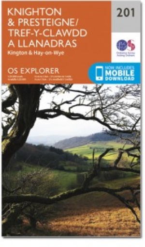
Wandelkaart 201 Knighton & Presteigne Wales - OSI • 9780319243947
Wandelkaart Knighton & Presteigne - Wales Kaart nummer 201 in de OS Explorer reeks omvat Knighton, Presteigne (Llanandras), Knighton (Tref-y-Clawdd) en Hay-on-Wye. Hoogtepunten van het gebied zijn onder meer: Shropshire Hills gebied van uitzonderlijke natuurlijke schoonheid AONB, rivier Lugg, River Wye, Wye Valley, Brecon Beacons National Park, Brecons, Brecon heuvels, Glyndwyrs manier en …

Wandelkaart 239 Lake Vyrnwy & Llanfyllin Wales - OSI • 9780319471111
Wandelkaart Lake Vyrnwy & Llanfyllin- Tanat Valley - Powys Wales Productbeschrijving: Kaart nummer 239 in de OS Explorer kaarten reeks is ideaal voor het ontdekken van de Tanat vallei en Llanfyllin in Noord-Wales. De nationale Trail van Llwybr Cenedlaethol loopt rechts over het gebied van deze kaart, zodat u de glooiende heuvels van Noord-Wales kunt verkennen. Andere hoogtepunten van het g…
Wandelkaart 160 Brecon Beacons NP - Powys Wales - OSI • 9780319474839
Wandelkaart Brecon Beacons NP - Powys Wales Productbeschrijving: OS Landranger kaart 160 is een al purpose kaart volgepakt met informatie om u een deftige vakantie in het Brecon Beacons National Park in Zuid-Wales te bieden. Het iconische landschap van Brecon Beacons is een thuis voor bossen, watervallen, marktsteden. De hoogste piek in zuidelijk Groot-Brittannië (Pen y Fan) die tot 886 me…

Wandelkaart 147 Elan Valley & Builth Wells - Wales - OSI • 9780319474709
Wandelkaart Elan Valley & Builth Wells - Powys - OSI Productbeschrijving: De OS Landranger kaarten reeks heeft betrekking op Groot-Brittannië met 204 gedetailleerde kaarten, perfect voor dagtochten en korte pauzes. Elke kaart bevat alle informatie die u nodig heeft om dit lokaal gebied te leren kennen en omvat plaatsen van belang, toeristische informatie, picknickplaatsen en campings, plus…

Wandelkaart 201 Knighton & Presteigne Wales - OSI • 9780319470732
Wandelkaart Knighton & Presteigne- Powys Wales Productbeschrijving: Kaart nummer 201 in de OS Explorer reeks omvat Knighton, Presteigne (Llanandras), Knighton (Tref-y-Clawdd) en Hay-on-Wye. Hoogtepunten van het gebied zijn onder andere: Shropshire Hills gebied van uitzonderlijke natuurlijke schoonheid AONB, rivier Lugg, River Wye, Wye Valley, Brecon Beacons National Park, Brecons, Brecon h…