
Wandelgids - GR10 Trail through the French Pyrenees - Cicerone
Le Sentier des Pyrénées- 955km lange tocht door de Pyreneeën
Korte omschrijving
Wandelgids - GR10 Trail through the French Pyrenees - Cicerone Productomschrijving: Wandelgids over de GR10, "Le Sentier des Pyrénées", een 955km lange tocht door de Franse Pyreneeën van He...

Stockactie
Specificaties
- Uitgever: CICERONE Press
- ISBN-13: 9781852847739
- HOOFDCATEGORIEËN: Wandelgids
- Activiteiten: Wandelen, Hiking & Trekking
- Regio: Occitanië, Frankrijk
- Land: Frankrijk
- Departement: Pyrénées-Orientales (66)
- Blz.: 320
- Afmeting: 12x17
- Editie: 1
- Taal: Engels
Volledige omschrijving
Wandelgids - GR10 Trail through the French Pyrenees - Cicerone
Productomschrijving: Wandelgids over de GR10, "Le Sentier des Pyrénées", een 955km lange tocht door de Franse Pyreneeën van Hendaye aan de Atlantische kust tot de Middellandse Zeekust in Banyuls-sur-Mer. Het boek beschrijft 55 etappes, met informatie over planning, vervoer, accommodatie en faciliteiten. U kunt de hele GR10 in ongeveer 45 dagen of in korter afleggen.
Productdescription: Guidebook to walking the GR10, the Sentier des Pyrénées, a 955km trek across the French Pyrenees from Hendaye on the Atlantic Coast to the Mediterranean coast at Banyuls-sur-Mer. The book describes 55 stages, with information on planning, transport, accommodation and facilities. Walk the entire GR10 in around 45 days or in shorter trips.
Product description: Guidebook to walking the GR10, the Sentier des Pyrénées, a 955km trek across the French Pyrenees from Hendaye on the Atlantic Coast to the Mediterranean coast at Banyuls-sur-Mer. The book describes 55 stages, with information on planning, transport, accommodation and facilities. Walk the entire GR10 in around 45 days or in shorter trips.
Seasons:
Best July to October (June in a low snow year).
Centres:
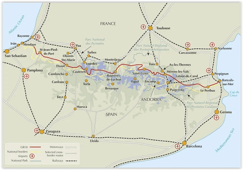
Hendaye-Plage on the Atlantic coast to Banyuls-sur-Mer on the Mediterranean through the French Pyrenees.
Difficulty:
The GR10 is extremely well waymarked following good mountain paths with short sections of boulderfield and occasional very easy scrambling. It is tough because there is more steep climb and descent than on many long-distance paths. Good network of inexpensive accommodation for those who prefer not to camp. Frequent resupply possible. In early season (May/June) ice-axe and crampons may be required.
Must See:
The GR10 starts with the rolling hills of the Basque country leading to the High Pyrenees including Pic du Midi d'Ossau, Vignemale and Gavarnie. The remote Ariège with Mont Vallier follows and Canigou dominates the approach to the Mediterranean. Wildflower meadows are magnificent throughout.
Locatie op kaart
Artikelen uit dezelfde regio

Wandelkaart 2641 OT Millau & Gorges de la Dourbie - IGN • 9782758545439
TOPO Wandelkaart Millau & Gorges de la Dourbie - IGN Productomschrijving: Millau & Causse Noir zijn Franse gemeentes bij de nabijgelegen Gorges de la Dourbie, in het departement van de Aveyron, in de regio Occitanië. Het ligt 70 km ten zuidoosten van Rodez en maakt deel uit van de voormalige provincie Rouergue. Desciptive produits: Ces cartes topographiques d'une très grande précision…

Wandelgids Gard - Dans le Gard - Ed. Glénat • 9782344046951
Wandelgids Gard - Dans le Gard Productomschrijving: 44 nieuwe wandelingen om de rijkdom van het departement Gard te ontdekken! Na het succes van de vorige editie biedt Alain Godon ons een gloednieuwe selectie van 44 wandelingen van de kust tot de Cevennen, in dit departement Gard dat rijk is aan een opmerkelijk plant- en cultureel erfgoed. En zoals hij het zo goed zegt: “Om je onder te…

Wandelkaart 2349 ET Massif du Canigou - IGN • 9782758553465
Wandelkaart Massif du Canigou Occitnië - IGN Productomschrijving: Het Canigou-massief is een massief in de Franse Pyreneeën in het departement Pyrénées-Orientales. Het Canigou-massief omvat het grootste massief van de Pyreneeën dat het dichtst bij de Middellandse Zee. Omvat: Le Tech, Prades, Valmanya, Lamanère, Corsavy, Montferrer, Fuilla, Finestret, Baillestavy, Escaro, Glorianes, Ria…

Fietsgids Canal des Deux-Mers à vélo - Ed. Ouest-France • 9782737386459
Canal des Deux-Mers à vélo - Royan à Sète - 850 km Productomschrijving: Voor het eerst uitgegeven door Ouest-France, Le Canal des Deux Mers à vélo in zijn geheel, van de Atlantische Oceaan tot de Middellandse Zee. De volledige fietsroute in 1 gids. Franse omschrijving: Pour la première fois, aux éditions Ouest-France, Le Canal des Deux Mers à vélo dans son intégralité, de l'Atlantique …

Wandelkaart 2542 OT Camarès & Avène - IGN • 9782758548713
TOPO Wandelkaart Camarès & Avène - IGN Productomschrijving: Camarès & Avène zijn gemeentes in het Franse departement Aveyron in de regio Occitanie. De plaats maakt deel uit van het arrondissement Millau. De TOP 25 kaarten, met nummers die eindigen op "T" hebben betrekking op gebieden van bijzonder toeristisch belang zoals de Alpen, de Pyreneeën, De Cevennes, de Vogezen, de Provence, en…