
Wandelgids South West Coast Path - Cicerone
Van Plymouth naar Poole langs de kustlijn van Devon en Dorset
Korte omschrijving
Map booklet South West Coast Path - Cicerone Productomschrijving: Kaart van een deel van het zuidelijke deel van het 630 mijl (1014 km) lange South West Coast Path National Trail. Omvat het ...

Specificaties
- Uitgever: CICERONE Press
- ISBN-13: 9781786312006
- HOOFDCATEGORIEËN: Wandelgids
- Activiteiten: Wandelen, Hiking & Trekking
- Regio: Devon, England, Dorset, England, South West England
- Land: United Kingdom, Great Britain
- Blz.: 112
- Schaal: 1:25000
- Afmeting: 12x17
- Editie: 2
- Taal: Engels
Volledige omschrijving
Map booklet South West Coast Path - Cicerone
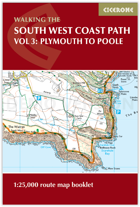
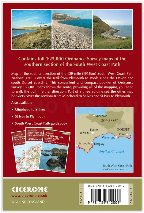
Productomschrijving: Kaart van een deel van het zuidelijke deel van het 630 mijl (1014 km) lange South West Coast Path National Trail. Omvat het pad van Plymouth naar Poole langs de kustlijn van Devon en Dorset. Dit handige en compacte boekje met Ordnance Survey 1:25.000 kaarten toont de route en biedt alle kaarten die je nodig hebt om het pad in beide richtingen te lopen.
Engelse omschrijving: Map of part of the southern section of the 630 mile (1014km) South West Coast Path National Trail. Covers the trail from Plymouth to Poole along the coastline of Devon and Dorset. This convenient and compact booklet of Ordnance Survey 1:25,000 maps shows the route, providing all of the mapping you need to walk the trail in either direction.
Seasons:
This National Trail may be walked year-round: be aware that winter accommodation availability may be limited, while high summer will be extremely busy and the weather often hot.
Centres:
Many centres are passed along the route, including Plymouth, Salcombe, Brixham, Weymouth, Swanage and Poole.
Difficulty:
The South West Coast path is a long walk! Most paths are easy to moderate, with some walks along rugged and exposed coastal cliff paths and some steep gradients.
Must See:
Exmoor National Park, Areas of Outstanding Natural Beauty, numerous Heritage Coasts, National and Local Nature Reserves, Sites of Special Scientific Interest and National Trust holdings.

Gekoppelde artikelen

Wandelgids South West Coast Path - Cicerone • 9781786312006
standaard versieMap booklet South West Coast Path - Cicerone Productomschrijving: Kaart van een deel van het zuidelijke deel van het 630 mijl (1014 km) lange South West Coast Path National Trail. Omvat het pad van Plymouth naar Poole langs de kustlijn van Devon en Dorset. Dit handige en compacte boekje met Ordnance Survey 1:25.000 kaarten toont de route en biedt alle kaarten die je nodig hebt om het pad i…

Wandelgids South West Coast Path North - Cicerone • 9781852849368
standaard versieWandelgids - South West Coast Path North - Cicerone Productomschrijving: Een eerste deel van het 1014km lange wandelpad die in deze gids loopt van Minehead tot St-Yves. Detail Uitgever: The South West Coast Path is Britain's longest National Trail, stretching some 630 miles (1014km) between Minehead in Somerset and Poole in Dorset. It takes in a National Park, 5 Areas of Outstanding Na…

Wandelgids South West Coast Path - Cicerone • 9781852849375
standaard versieWandelgids - South West Coast Path - Cicerone Productomschrijving: DEEL 2 - Dit deel betref het zuidelijke deel van de South west Coast path in Devon England - St-Ives to Plymouth Product description: The South West Coast Path is Britain's longest National Trail, stretching some 630 miles (1014km) between Minehead in Somerset and Poole in Dorset. It takes in a National Park, 5 Areas of…
Artikelen uit dezelfde regio

Wandelkaart 141 Cheddar Gorge & Mendip Hills - OSI • 9780319243343
Wandelkaart Cheddar Gorge & Mendip Hills West - Devon - OSI Productbeschrijving: Wells & Glastonbury 141 / Cheddar Gorge & Mendip Hills West, Devon, England - Kaart nummer 141 in de OS Explorer reeks heeft betrekking op de westelijke heuvels van Mendip, Cheddar, Wells, Street en Glastonbury. Hoogtepunten van het gebied zijn onder andere: Cheddar Gorge, Wookey Hole, Glastonbury Tor, Bl…

Wandelkaart 201 Plymouth & Launceston England - OSI • 9780319475249
Wandelkaart Plymouth & Launceston - South West England Productbeschrijving: Kaart nummer 201 in de OS Landranger kaarten reeks, is de ideale kaart om te gebruiken bij het plannen van excursies naar Plymouth, Launceston, Tavistock en Looe. Plymouth houdt vele attracties met zijn rijke maritieme geschiedenis en het aantrekkelijke landschap eromheen. Hoogtepunten van het gebied zijn onder and…

Wandelkaart 139 - Bideford & Ilfracombe- Devon - OSI • 9780319243329
Wandelkaart Bideford- Ilfracombe & Barnstaple - Devon England Productbeschrijving: - Woolacombe & Lundy. 139 / Bideford, Ilfracombe & Barnstaple, Devon, England - Kaart nummer 139 in de OS Explorer reeks omvat Ilfracombe, Bideford, Barnstaple, Westward Ho!, Woolacombe, en Lundy Island, en laat een deel van de South West Coast Path zien. De OS Explorer kaart voor Bideford, Ilfracombe & …

Wandelkaart 111 Bude- Boscastle & Tintagel- Devon - OSI • 9780319243121
Wandelkaart Bude- Boscastle & Tintagel - Devon - OSI Productomschrijving: 111 / Bude, Boscastle & Tintagel, Devon, England - Kaart nummer 111 in de reeks OS Explorer is de perfecte kaart te gebruiken om te wandelen, fietsen of om te kamperen in- en rond Bude, Boscastle en Tintagel. Alle drie de plaatsen kunnen worden bezocht langs de South West Coast Path. Hoogtepunten van het gebied zijn …

Wandelkaart South West Coast Path 2 - Harvey maps • 9781851374274
Wandelkaart - South West Coast Path 2 - Harvey maps - Covers: The path from Bude to Portreath. Productomschrijving: Waterdichte XT40 kaart van Harvey. Een ideale kaart voor wandelaars op de langste en op één van haar meest populairste nationale routes. Het loopt langs de kust van Somerset, Cornwall en Devon, Dorset van Minehead round via Land's end naar Poole. Het omvat alle 95 mijls …