
Wandelgids The John Muir Way - Rucksack Readers
From Helensburgh on the Clyde to Dunbar on the North Sea
Korte omschrijving
The John Muir Way - Rucksack Readers Productomschrijving: De John Muir Way loopt over een afstand van 215 km, van kust tot kust door centraal Schotland, van Helensburgh aan de Clyde naar Dun...

Specificaties
- Uitgever: RUCKSACK READERS
- ISBN-13: 9781913817145
- HOOFDCATEGORIEËN: Wandelgids
- Activiteiten: Wandelen, Hiking & Trekking
- Auteur: Sandra Bardwell
- Regio: Highlands, Schotland
- Land: Schotland
- Historische wandelroutes: John Muir Way (215 km)
- Lange afstand wandelroutes: John Muir Way (215 km)
- Blz.: 88
- Schaal: 1:75000
- Afmeting: 13x22
- Editie: 3
- Taal: Engels
Volledige omschrijving
The John Muir Way - Rucksack Readers
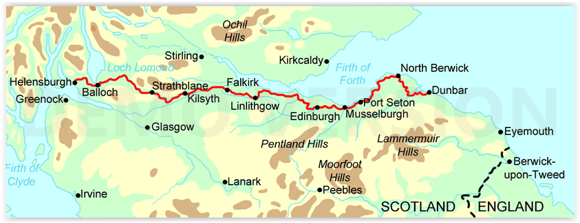
Productomschrijving: De John Muir Way loopt over een afstand van 215 km, van kust tot kust door centraal Schotland, van Helensburgh aan de Clyde naar Dunbar aan de Noordzee. De route is net zo geschikt voor fietsers als voor wandelaars en kan van kust tot kust worden afgelegd of in delen - tien voor wandelaars of vijf voor fietsers.
De aantrekkingskracht van de John Muir Way reikt van de Charles Rennie Mackintosh-architectuur van Helensburgh via de schilderachtige grandeur van Loch Lomond, langs twee beroemde kanalen en langs het verbazingwekkende Falkirk Wheel, naast de Romeinse Antonijnse Muur, langs Linlithgow Palace, Blackness Castle en de Forth Bridges naar de hoofdstedelijke glorie van Edinburgh. De tocht gaat langs de Firth of Forth naar North Berwick en vervolgens landinwaarts om te eindigen in Dunbar met zijn kasteelruïne en het geboortehuis van John Muir.
Engelse omschrijving: The John Muir Way runs for 134 miles (215 km) coast-to-coast across central Scotland, from Helensburgh on the Clyde to Dunbar on the North Sea. The route is as suitable for cyclists as for walkers, and it can be tackled as a coast-to-coast expedition or in sections - ten for walkers or five for cyclists.
The John Muir Way's appeal ranges from the Charles Rennie Mackintosh architecture of Helensburgh through the scenic grandeur of Loch Lomond, along two famous canals and past the amazing Falkirk Wheel, beside the Roman Antonine Wall, passing Linlithgow Palace, Blackness Castle and the Forth Bridges to the capital glories of Edinburgh. It goes beside the Firth of Forth to reach North Berwick, then heads inland to finish at Dunbar with its ruined castle and the John Muir birthplace.
This guidebook contains all you need to plan and enjoy your holiday on a bike or on foot:
• background on John Muir's life, the canal heritage and wildlife
• detailed description of the route from west to east
• summary of each section showing distance, terrain and food/drink stops
• details of visitor attractions and side-trips
• planning information for travel by car, train, bus or plane
• detailed mapping of the John Muir Way on 20 pages
• in full colour, with 100 photographs
• further route options, diversions and an unofficial shortcut
• rainproof paper throughout.
Artikelen uit dezelfde regio

Wandelgids West Highland way trekking guide - Knife Edge • 9781912933112
West Highland way trekking guide - Knife Edge Productomschrijving: De West Highland Way, één van de "Great Trails" van Schotland, voert over een afstand van 96 mijl door een subliem landschap, van de buitenwijken van Glasgow naar Fort William. Tussendoor zijn er ontelbare prachtige bergen, prachtige valleien, glinsterende lochs en schijnbaar eindeloze kilometers paarse heide te beleven. De…

Wandelkaart 445 Foinaven- Arkle & Kylesku- Schotland - OSI • 9780319246887
Wandelkaart Foinaven- Arkle & Kylesku - Highlands Schotland Productbeschrijving: 445 / Foinaven, Arkle & Kylesku, Highlands, Schotland - OS Explorer kaart 445 toont in het uiterste noord-westen, Foinaven, Arkle, Kylesku & Scourie. Het omvat ook de nationale landschappelijke gebieden van North-West Sutherland Assynt-Coigach, Loch, Loch Laxford maken en The Minch. De OS Explorer kaart vo…

Wandelkaart 431 Glen Urquhart & Strathglass- Schotland OSI • 9780319472835
Wandelkaart Glen Urquhart & Strathglass - Highland's Schotland Omvat ook: Drumnadrochit & Muir of Ord. Productbeschrijving: Ten westen van de Highland hoofdstad van Inverness, toont OS Explorer kaart 431 toont Drumnadrochit noordelijk naar Muir of Ord. Het omvat de nationale Scenic gebied van Strathfarrar, het Orrin Reservoir, en een kleine hoeveelheid van de Great Glen way. De OS Expl…

Reisgids Schotland's Highlands & Islands - Lonely Planet • 9781787016439
Schotland's Highlands & Islands - Lonely Planet Productomschrijving: The hills and glens and wild coastline of Scotland’s Highlands and islands offer the ultimate escape – one of the last corners of Europe where you can discover genuine solitude. Lonely Planet will get you to the heart of Scotland’s Highlands & Islands, with amazing travel experiences and the best planning advice: …

Wandelkaart 34 Fort Augustus- Loch Ness Highland's - OSI • 9780319261323
Wandelkaart Fort Augustus- Loch Ness - Highland's Schotland Omvat ook: Glen Albyn & Glen Roy Productomschrijving: Gelegen aan de zuidelijke oevers van de wereld beroemde Loch Ness, is Fort Augustus het charmante dorp omgeven door iconische Schotse landschap. OS Landranger kaart 34 toont de Great Glen way die de regio passeert waardoor het een aantrekkelijke uitvalsbasis word voor wande…