
Wandelgids Walking on the North Wessex Downs - Cicerone
De North Wessex Downs in Berkshire- Hampshire & Wiltshire
Korte omschrijving
Wandelgids - Walking on the North Wessex Downs - Cicerone Productomschrijving: 30 wandelroutes verkennen de North Wessex Downs, Area of Outstanding Natural Beauty (AONB). De routes zijn tuss...

Specificaties
- Uitgever: CICERONE Press
- ISBN-13: 9781852847289
- HOOFDCATEGORIEËN: Wandelgids
- Activiteiten: Wandelen, Hiking & Trekking
- Auteur: Steve Davison
- Regio: Wessex, England, Wiltshire, West England
- Land: England
- AONB - Area of Outstanding Beauty: North Wessex Downs AONB
- Blz.: 192
- Afmeting: 12x17
- Editie: 1
- Taal: Engels
Volledige omschrijving
Wandelgids - Walking on the North Wessex Downs - Cicerone
Productomschrijving: 30 wandelroutes verkennen de North Wessex Downs, Area of Outstanding Natural Beauty (AONB). De routes zijn tussen de 7 tot 20 kilometer door dit rustige glooiende krijtlandschap die deel uitmaakt van vier provincies: Berkshire, Hampshire, Wiltshire en Oxfordshire, met beschrijving van de hoogste punten en hoe ze te bereiken.
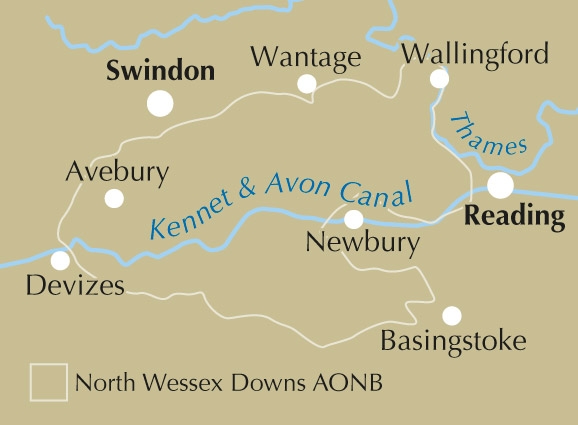
Product description: 30 walking routes exploring the North Wessex Downs Area of Outstanding Natural Beauty (AONB). The routes are between 7 and 20km through this peaceful rolling chalk landscape covering parts of four counties: Berkshire, Hampshire, Wiltshire and Oxfordshire, with descriptions to reach the highest points in each one.
Seasons:
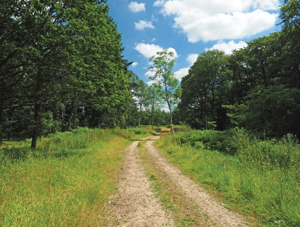
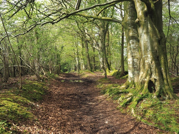
All year round. Spring and early summer are best for wild flowers, butterflies and birds; in autumn the trees are splashed in golden-brown autumnal colours, while a frosty winter's day can give impressive clear views
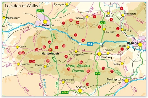
Centres:
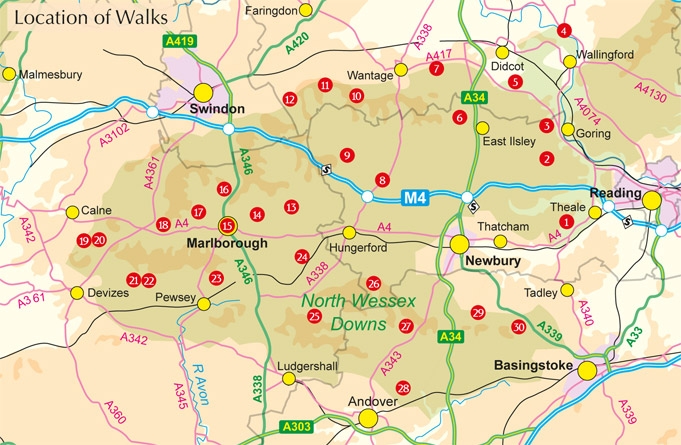
Marlborough, Lambourn, Great Bedwyn, Dorchester on Thames, Hungerford, Pewsey, Kingsclere The walks are accessible from the following towns outside of the area: Didcot, Wantage, Swindon, Calne, Devizes, Andover, Basingstoke, Newbury and Reading.
Difficulty:
Walks to suit most ages and abilities; no difficulties apart from some short steep uphill and downhill sections; can be muddy in winter.
Must See:
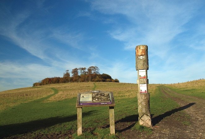
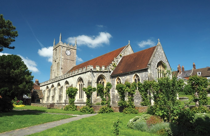
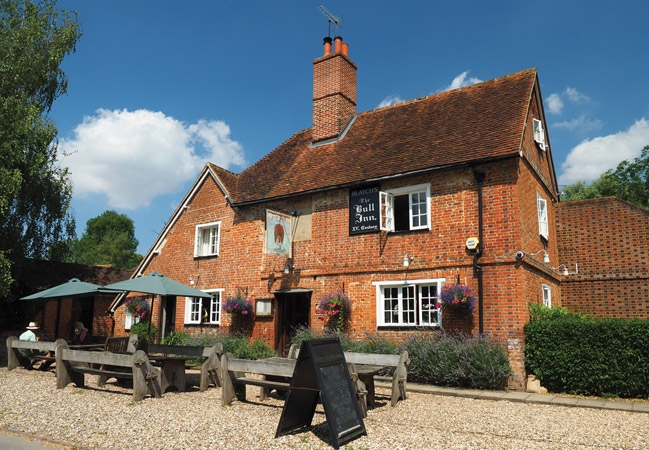
Panoramic views, the highest points in Berkshire, Hampshire, Wiltshire and Oxfordshire; the rivers Thames, Kennet, Pang and Lambourn; picturesque villages with thatched cottages, historic churches and cosy pubs. Prehistoric sites; Avebury, the Uffington White Horse, Neolithic and Bronze Age long barrows and Iron Age hill forts.
Locatie op kaart
Overzichtskaarten

Area's of Outstanding Natural Beauty - AONB's UK
Area's of Outstanding Natural Beauty - AONB's UK

Producten op de overzichtskaart
Klik op een product om naar de detailpagina te gaan.
- Wandelgids - Guide to the Cotswolds AONB - AA
- Wandelkaart 24 - Chilterns AONB - AA
- Fietskaart- en Mtb kaart - The Cotswolds - Goldeneye
- Wandelgids - Cotswold classic walks guidebook - Goldeneye
- Wandelkaart - Cotswold South AONB - Goldeneye
- Wandelgids - Exploring the Cotswolds - Goldeneye
- Wandelgids - Cotswold Classic Walks - Goldeneye
- Wandelkaart - Cotswolds- Malverns & Forest of Dean - Goldeneye
- Wandelgids - The Cotswold Way 30 classic routes - Cicerone
- Wandelgids - Kent walking guide - Cicerone
- Wandelgids - North Downs Way Nat. trail - Cicerone
- Wandelgids - Chilterns walking guide - Cicerone
- Wandelgids - Suffolk coast & Heaths walks - Cicerone
- Wandelgids - North Downs Way - Map Booklet - Cicerone
- Wandelgids - North Pennines AONB walking guide - Cicerone
- Wandelgids - Ridgeway National Trail - Cicerone
- Wandelgids - Forest of Bowland & Pendle - Cicerone
- Wandelgids - Hampshire's Test Way walking guide - Cicerone
- Wandelgids & Fietsgids - The Cotswold AONB - Cicerone
- Wandelgids - Walking on the Gower - Cicerone
- Wandelgids - North Wessex Downs - Cicerone Press
- Wandelgids - Walking on the North Wessex Downs - Cicerone
- Wandelgids - Silverdale & Arnside AONB - Cicerone
- Wandelgids - The Kennet and Avon Canal walking guide - Cicerone
- Wandelgids - North Downs Way- 246 km - Trailblazer
- Wandelkaart OL2 - Yorkshire Dales- Southern & Western Areas - OSI
- Wandelkaart OL19 - Howgill Fells and Upper Eden Valley - OSI
- Wandelkaart OL21 - South Pennines - Yorkshire - OSI
- Wandelkaart OL31 - North Pennines- Teesdale & Weardale - OSI
- Wandelkaart OL40 - The Broads - OSI
- Wandelkaart OL41 - Forest of Bowland & Ribblesdale - OSI
- Wandelkaart OL45 - The Cotswolds AONB- Gloucestershire - OSI
- Wandelkaart 108 - Lower Tamer Valley & Plymouth- Cornwall- OSI
- Wandelkaart 115 - Exmouth & Sidmouth- Devon - OSI
- Wandelkaart 137 - Ashford- Kent downs AONB- England - OSI
- Wandelkaart 140 - Quantock Hills AONB- Somerset - OSI
- Wandelkaart 140 - Quantock Hills AONB & Bridgwater- Devon - OSI
- Wandelkaart 147 - Sevenoaks & Tonbridge- Kent - OSI
- Wandelkaart 164 - Gower AONB & Gwyr- South Wales - OSI
- Wandelkaart 164 - Gower AONB & Gwyr- Wales - OSI
- Wandelkaart 171 - Chiltern Hills West & Henley-on-Thames OSI
- Wandelkaart 171 - Chiltern Hills West AONB- Wycombe - OSI
- Wandelkaart 172 - Chiltern Hills East AONB- Wycombe - OSI
- Wandelkaart 181 - Chiltern Hills AONB North- England - OSI
- Wandelkaart 181 - Chiltern Hills North AONB- Wycombe - OSI
- Wandelkaart 190 - Malvern Hills & Bredon Hill - OSI
- Wandelkaart 190 - Malvern Hills AONB & Bredon Hill - OSI
- Wandelkaart 203 - Ludlow- Shropshire Hills AONB - OSI
- Wandelkaart 217 - Long Mynd & Wenlock Edge- Schropshire- OSI
- Wandelkaart 254 - Lleyn Peninsular East- North Wales - OSI
- Wandelkaart 261 - Boston- Lincolnshire AONB - OSI
- Wandelkaart 262 - Anglesey West- Wales AONB - OSI
- Wandelkaart 263 - Anglesey East AONB- Wales - OSI
- Wandelkaart 273 - Lincolnshire Wolds South AONB - OSI
- Wandelkaart 282 - Lincolnshire Wolds North AONB - OSI
- Wandelkaart 298 - Nidderdale AONB- Yorkshire - OSI
- Wandelkaart 298 - Nidderdale AONB North Yorkshire - OSI
- Wandelkaart 300 - Howardian Hills AONB - OSI
- Wandelkaart 300 - Howardian Hills AONB & Malton - OSI
- Wandelkaart - Mourne Mountains N. Ireland - Harvey maps
- Wandelkaart - Fietskaart Forest of Bowland - Harvey maps
- Wandelkaart XT40 - Anglesey Coastal Path N. Wales - Harvey Maps
- Wandelkaart XT40 - Pennine Way Noord - Harvey Maps
- Wandelkaart XT40 - Pennine Way Zuid - Harvey Maps
- Wandelgids Cotswold - Way Two-way trekking guide - Knife Edge
- Reisgids Oxford & the Cotswolds AONB - Edicola
- Reisgids Cotswolds England - Rough Guides
- Reisgids Go Slow- Sussex & the South Downs- Weald & Coast - Bradt
- Travelguide Oxford & The Cotswolds pocket guide - Lonely Planet
- Wandelgids - The Ridgeway National trail - Trailblazer
Artikelen uit dezelfde regio

Wandelkaart 157 Marlborough & Savernake Forest - OSI • 9780319470299
Wandelkaart Marlborough & Savernake Forest - Wiltshire Omvat ook: Avebury & Devizes. Productbeschrijving: Kaart nummer 157 in de OS Explorer kaarten reeks omvat Marlborough, Avebury en Devizes in Wiltshire. Hoogtepunten van het gebied zijn onder andere: een deel van de Great Western Community Forest, North Wessex Downs AONB, Savernake Forest, Avebury Rings, Wessex Ridgeway, The Ridgewa…

Wandelkaart Cotswold South AONB - Goldeneye • 9781859652541
Wandelkaart Cotswold South - Goldeneye Productomschrijving: Verken de zuidelijke Cotswolds AONB, met deze waterdichte Cotswolds-wandelkaart. Met 10 cirkelvormige rondwandelingen en duidelijk gemarkeerde routes zal deze gebruiksvriendelijke kaart u helpen de Cotswolds te ontdekken. Stap in de Cotswolds met deze uitzonderlijk mooie wandelingen. Ontdek idyllische honingkleurige stenen dorpjes…

Wandelkaart 173 Swindon- Devizes & Marlborough - OSI • 9780319474969
Wandelkaart Swindon- Devizes & Marlborough - Witlshire De OS Landranger kaarten reeks heeft betrekking op Groot-Brittannië met 204 gedetailleerde kaarten, perfect voor dagtochten en korte pauzes. Elke kaart bevat alle informatie die u nodig heeft om dit lokaal gebied te leren kennen en omvat plaatsen van belang, toeristische informatie, picknickplaatsen en campings, plus doorgangsrechten i…

Wandelkaart Cotswolds- Malverns & Forest of Dean - Goldeneye • 9781859652893
Cotswolds- Malverns & Forest of Dean - Goldeneye Productomschrijving: Een samenstelling van wandelkaart en bijhorende wandelgids, over enkele van de meest bezochte wandellocaties van Engeland, zowel de Cotwolds als Marvern Hills zijn beiden geklasseerd als AONB regio's of meerbepaald, Gebieden van uitmuntend natuurschoon. deze gebieden, met de Forest of Dean inbegrepen zijn allemaal bij el…

Wandelkaart 156 Chippenham & Bradford-on-Avon - OSI • 9780319243497
Wandelkaart Chippenham & Bradford-on-Avon - Wiltshire Productbeschrijving: Trowbridge & Melksham. 156 / Chippenham & Bradford-on-Avon, wiltshire, England - Kaart nummer 156 in de OS Explorer reeks heeft betrekking op een gedeelte van de North Wessex Downs AONB en Cotswolds rond Melksham en Bradford-on-Avon. Hoogtepunten van het gebied zijn de steden Chippenham en Trowbridge samen met …