
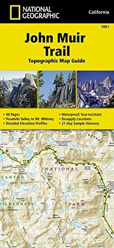
Wandelkaart 1001 - John Muir Trail - Nat Geo
Doorkruist Yosemite- Kings Canyon en Sequoia National Park
Korte omschrijving
TOPO Wandelkaart 1001 - John Muir Trail - National Geographic Productomschrijving: De John Muir Trail - is een langeafstandswandelpad in het Sierra Nevada-gebergte in de Amerikaanse staat Ca...

Specificaties
- Uitgever: National Geographic
- ISBN-13: 9781566956895
- HOOFDCATEGORIEËN: Wandelkaart
- Activiteiten: Wandelen, Hiking & Trekking
- Regio: Californië, USA
- Land: Verenigde Staten van Amerika (USA)
- Lange afstand wandelroutes: John Muir Way (215 km)
- Blz.: 48
- Schaal: 1:63360
- Afmeting: 10x19
- Taal: Engels
Volledige omschrijving
TOPO Wandelkaart 1001 - John Muir Trail - National Geographic
Productomschrijving: De John Muir Trail - is een langeafstandswandelpad in het Sierra Nevada-gebergte in de Amerikaanse staat Californië. Het is vernoemd naar de Schots-Amerikaanse natuurvorser en schrijver John Muir, die een cruciale rol speelde in de bescherming van de nationale parken van Californië. Het 338,6 kilometer lange pad doorkruist Yosemite, Kings Canyon en Sequoia National Park. Het merendeel van het pad (zo'n 260 km) valt samen met de Pacific Crest Trail, dat van de Mexicaanse grens naar de Canadese loopt.
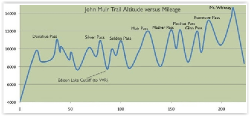
Engelse omschrijving: National Geographic's Map Guide of the John Muir Trail is an indispensable tool for navigating one of the most famous trails in the United States. Expertly researched and created in partnership with local land management agencies, this product provides detailed topographic maps, interesting history, a waypoint table, information about wilderness safety, and key points of interest you will encounter along the trail. A resupply location chart shows shipping address/contact information, distances, and services available at each resupply point. Each map page has a detailed trail profile that shows the elevation changes you will encounter. Also, the John Muir Trail is highlighted and centered on each page so you can easily track your progress.
The maps start at the northern terminus in Yosemite Valley and progress along the ridge of the Sierra Nevada, past Devils Postpile, and end at the highest point in the lower 48 on the top of Mount Whitney. Along the way you will pass through; Yosemite National Park, Ansel Adams Wilderness, Devils Postpile National Monument, John Muir Wilderness, Kings Canyon National Park, and finally, Sequoia National Park and Mount Whitney. A 21-day sample itinerary is included as well. Every Topographic Map Guide is printed on "Backcountry Tough" waterproof, tear-resistant paper. A full UTM grid is printed on the map to aid with GPS navigation.
Other features found on this map include: Ansel Adams Wilderness, Bridalveil Fall, El Capitan, Illilouette Falls, Inyo National Forest, John Muir Wilderness, Kings Canyon National Park, Lake Thomas A Edison, Lower Yosemite Fall, Middle Palisade, Mount Agassiz, Mount Darwin, Mount Muir, Mount Pinchot, Mount Powell, Mount Ritter, Mount Russell, Mount Tyndall, Mount Whitney, Mount Williamson, Nevada Fall, North Palisade, Ribbon Fall, Ritter Range, Sequoia National Park, Sierra National Forest, Sierra Nevada, Split Mountain, Upper Yosemite Falls, Vernal Fall, Yosemite National Park, Yosemite Valley.
.png)
Locatie op kaart
Artikelen uit dezelfde regio

Reisgids Los Angeles- San Francisco & Las Vegas - Anwv Extra • 9789018049782
Reisgids Los Angeles- San Francisco & Las Vegas - Anwv Productomschrijving: ANWB Extra reisgids Los Angeles, San Francisco en Las Vegas - Amerika Ontdek Los Angeles, San Francisco en Las Vegas met de compleet vernieuwde reisgids ANWB Extra Los Angeles, San Francisco en Las Vegas! In deze Amerikaanse driehoek komt elke vakantieganger aan zijn trekken. De natuurliefhebber in Big Sur en d…

Wandelkaart 308 Yosemite NE- Tuolumne Meadows - Nat Geo • 9781566953696
Yosemite North East - Tuolumne Meadows - Nat Geo Productomschrijving: National Geographic's Trails Illustrated kaart van Yosemite NE: Tuolumne Meadows and Hoover Wilderness is ontworpen om te voldoen aan de behoeften van outdoor enthousiastelingen door het combineren van waardevolle informatie met ongeëvenaarde details van deze prachtige regio van het park. Deskundig onderzocht en gemaakt …

Reisgids California - Insight Guides ENG • 9781839053306
Reisgids California - Insight Guides Productomschrijving: Van het beslissen wanneer je gaat tot kiezen wat je gaat zien als je aankomt, dit is alles wat je nodig hebt om je reis te plannen en het beste van Californië te ervaren, met diepgaande insiderinformatie over must-see topattracties zoals Hollywood en verborgen culturele juweeltjes zoals de Pacific Coast Highway. Engelse om…

Wandelgids Best Day Walks California - Lonely Planet • 9781838691172
Best Day Walks California - Lonely Planet Productomschrijving: Lonely Planet's Best Day Walks Californië is uw paspoort met 60 gemakkelijke wandel ontsnappingen in de natuur. Strek je benen weg van de stad door een wandeling te kiezen die bij je past, van een paar uur tot een hele dag, van gemakkelijk tot zwaar. Verken Yosemite National Park, bewonder de sequoia's en wandel door Gold Count…

Reisgids San Francisco & Northern California - DK Eyewitness • 9780241360071
San Francisco & Northern California Omvat: Presidio, Pacific Heights and the Marina, Fisherman's Wharf and North Beach, Chinatown and Nob Hill, Financial District and Union Square, Civic Center, Haight Ashbury and the Mission, Golden Gate Park and Land's End, and sights beyond the city, plus major parts of Northern California including Carmel, Mendocino, Napa Wine Country, Lake Tahoe & Yos…