
Wandelgids California & Southwest USA's NP's - Lonely Planet
Joshua Tree- Redwood- Sequoia- Yosemite- Grand Canyon- Zion
Korte omschrijving
Wandelgids California & Southwest USA's National Parks Productomschrijving: Lonely Planet's California and Southwest USA's National Parks is uw paspoort voor het meest actuele advies over wa...

Specificaties
- Uitgever: Lonely Planet Publications
- ISBN-13: 9781838696061
- Auteur: Amy Balfour, Andrea Schulte-Peevers, Anita Isalska, Anthony ham, Ashley Harrell, Bradley Mayhew, Brendan Sainsbury, Brett Atkinson, Carolyn McCarthy, Celeste Brash, Christopher Pitts, Greg Benchwick, Greg Ward, Gregor Clark, Jade Bremner, Jennifer Rasin Denniston, Karla Zimmerman, Loren Bell, Mark Johanson, Michael Grosberg, Regis St Louis
- Regio: Californië, USA, Utah, USA
- Land: Verenigde Staten van Amerika (USA)
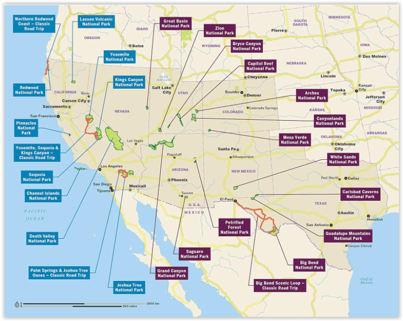
- Nationale parken: Grand Canyon NP, Arizona, Joshua Tree NP, California USA, Redwood Nationale Park, California USA, Sequoia & Kings Canyon NP, California USA, Yosemeti NP, California USA, Zion NP, Utah Verenigde staten
- Blz.: 258
- Afmeting: 13x20
- Editie: 1
- Taal: Engels
Volledige omschrijving
Wandelgids California & Southwest USA's National Parks
Productomschrijving: Lonely Planet's California and Southwest USA's National Parks is uw paspoort voor het meest actuele advies over wat je moet zien en overslaan. Wandel door de Grand Canyon, bewonder Sequoia en jaag op watervallen in Yosemite; allemaal met je vertrouwde reisgenoot. Duik in het hart van de nationale parken van Californië en het zuidwesten van de VS en begin je reis nu!
Omvat: Joshua Tree, Redwood, Sequoia, Yosemite, Grand Canyon, Zion.
Engelse omschrijving: Lonely Planet's California and Southwest USA's National Parks is your passport to the most up-to-date advice on what to see and skip. Hike down the Grand Canyon, marvel at Sequoia and chase waterfalls in Yosemite; all with your trusted travel companion. Get to the heart of California and Southwest USA's National Parks and begin your journey now!
Inside the Lonely Planet's California and Southwest USA's National Parks Travel Guide:
- Up-to-date information - all businesses were rechecked before publication to ensure they are still open after 2020's COVID-19 outbreak - User-friendly highlights and itineraries help you tailor your trip to your personal needs and interests - Insider tips to save time and money and get around like a local, avoiding crowds and trouble spots - Essential info at your fingertips - hours of operation, phone numbers, websites, transit tips, prices, emergency information. - Focused on the best hikes, drives, and cycling tours - Honest reviews for all budgets - eating, sleeping, camping, sightseeing, going out, shopping, summer and winter activities - Contextual insights give you a richer, more rewarding travel experience - history, geology, wildlife, and conservation - Over 52 full-color trail and park maps and full-color images throughout - Useful features- Travel with Children,Clothing and Equipment, andDay and Overnight Hikes.
Artikelen uit dezelfde regio

Wandelkaart 702 Cedar Mountain - Utah USA - Nat Geo • 9781566953061
Wandelkaart Cedar Mountain - Utah USA - Nat Geo Omvat: Ashdown Gorge Wilderness, Brian Head, Dixie National Forest, Kolob Terrace, Little Salt Lake, Markagunt Plateau, Panguitch Lake, Parowan Valley, Pine Valley Mountain Wilderness, Pine Valley Mountains, Signal Peak. Engelse omschrijving: Cedar City is the headquarters of the Dixie National Forest which is a two-million-acre, 170-mile…

Wandelkaart 1001 - John Muir Trail - Nat Geo • 9781566956895
TOPO Wandelkaart 1001 - John Muir Trail - National Geographic Productomschrijving: De John Muir Trail - is een langeafstandswandelpad in het Sierra Nevada-gebergte in de Amerikaanse staat Californië. Het is vernoemd naar de Schots-Amerikaanse natuurvorser en schrijver John Muir, die een cruciale rol speelde in de bescherming van de nationale parken van Californië. Het 338,6 kilometer lange…

Wandelkaart 704 Flaming Gorge- Recreational Area - Utah • 9781566954143
TOPO Wandelkaart 704 - Flaming Gorge- Recreational Area - Nat Geo Productomschrijving: Het Flaming Gorge National Recreation Area is een gebied rond het Flaming Gorge Reservoir en de Green River. Het ligt voor het grootste deel in het zuidwesten van de staat Wyoming en voor het overige deel in het noordoosten van de staat Utah van de Verenigde Staten. Deze National Recreation Area ligt ten…

Wandelkaart 709 Wasatch Front North Utah - Nat Geo • 9781566953702
Wasatch Front North - Utah - Nat Geo Omvat: Bountiful, Centerville, Cottonwood Heights, Currant Creek Peak, Daniels Canyon, Deer Creek Reservoir, Draper, Highland, Holladay, Lindon, Lone Peak Wilderness, Midvale, Mount Olympus Wilderness, Mount Timpanogos, Mount Timpanogos Wilderness, Murray, North Salt Lake, Orem, Pleasant Grove, Provo, Provo River, Rockport Lake, Salt Lake City, South Sa…

Wandelkaart 700 Ogden- Monte Cristo Range Utah USA - Nat Geo • 9781566956345
Ogden- Monte Cristo Range- Utah USA - Nat Geo Productomschrijving: Outdoor enthousiastelingen die willen genieten van de grenzeloze recreatieve mogelijkheden in het noorden van Utah net ten oosten van Great Salt Lake zullen zich vergapen aan National Geographic's Trails Illustrated kaart van Ogden en de Monte Cristo Range. Ontworpen met een breed scala van bezoekers in het achterhoofd, wer…