
Wandelgids Pyrenean Haute Route - Cicerone
Vergelijkbaar met de GR10

Korte omschrijving
Wandelgids - Pyrenean Haute Route - Cicerone Productomschrijving: There are three main trekking routes across the Pyrenees from coast to coast: of these, the Pyrenean Haute Route (or HRP fo...

Specificaties
- Uitgever: CICERONE Press
- ISBN-13: 9781852849818
- HOOFDCATEGORIEËN: Wandelgids
- Activiteiten: Wandelen, Hiking & Trekking
- Auteur: Tom Martens
- Regio: Pyreneeën
- Land: Frankrijk
- GR® routes: GR10
- Blz.: 344
- Afmeting: 12x17
- Editie: 3
- Taal: Engels
Volledige omschrijving
Wandelgids - Pyrenean Haute Route - Cicerone
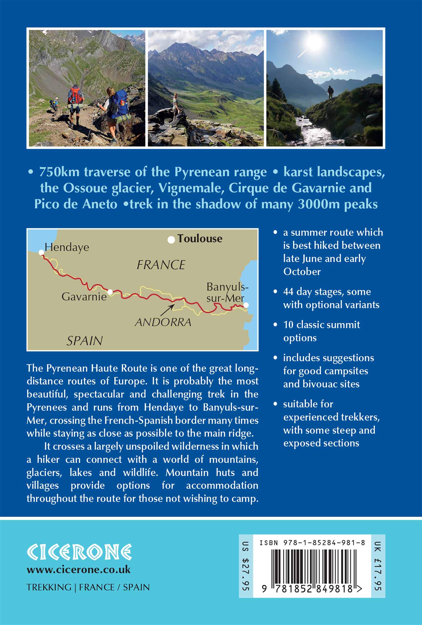
Productomschrijving: There are three main trekking routes across the Pyrenees from coast to coast: of these, the Pyrenean Haute Route (or HRP for Haute Route Pyrénéenne) is the most challenging - and arguably, the most spectacular. Unlike the GR10 and GR11, it is not waymarked and borders on mountaineering at times, sticking as closely as possible to the main ridge.
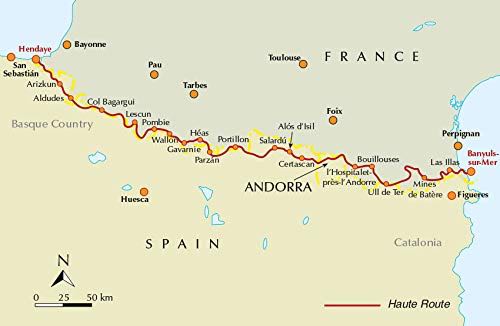
It stretches 750km from the Atlantic resort of Hendaye to Banyuls-sur-Mer on the Mediterranean, crossing the French-Spanish border many times on its traverse. The hike calls for experience, navigational competence and self-reliance, but offers rich rewards as you pass through some of the most stunning landscapes the region has to offer.
This guide presents the Pyrenean Haute Route in 44 day stages, which are divided between five sections: since each section starts and finishes at a location accessible by public transport, they can be walked individually if you don't have a spare month-and-a-half for a complete thru-hike. Although the route offers excellent opportunities for wild camping, each stage finishes at a mountain hut or village, meaning that you can sleep under a roof every night if you prefer. Clear route description is accompanied by 1:100,000 mapping. There are bad weather variants and alternatives to avoid the most technical sections, and the guide also includes optional ascents of 10 classic summits, including Vignemale, Pic du Taillon and the highest peak in the Pyrenees, Pico de Aneto. You'll also find helpful advice on travel to and from the route, equipment and safety.
From the rolling green foothills of the Basque Country to High Pyrenean landscapes of aquamarine lakes nestled among 3000m peaks, the scenery is as varied as it is beautiful. Highlights include the karst terrain of Pic d'Anie, the Ossoue glacier, Lac de Mar in the picturesque Val d'Aran and the dramatic Cirque de Gavarnie with its towering cascade.
Locatie op kaart
Artikelen uit dezelfde regio

Wandelgids Les pus beaux treks des Pyrénées - Ed. Glénat • 9782344034712
Wandelgids - Les pus beaux treks des Pyrénées - Ed. Glénat Productomschrijving: De mooiste tochten in La Balaguère om de Frans-Spaanse Pyreneeën te ontdekken. Na het succes van Les plus beaux treks des Alpes, wilden we een prachtig boek wijden aan de mooiste trekkings in de Pyreneeën. En met La Balaguère, het wandelreisbureau dat gespecialiseerd is in de Pyreneeën, hebben we dit boek samen…

Wandelkaart - Pyreneeën Spanje - Ed. Alpina • 9788480906371
Wandelkaart Pyreneeën - Alpina Productomschrijving: Wel omschreven wandelkaarten die de bekende Pyreneeën dekken, met alle mogelijke ingetekende wandelroutes, en toeristen informatie, als ook de nodige bezienswaardigheden zijn erop aangeduid. Spaanse kaart deels in het Engels. Ook vermeld zijn drie verschillende Grand Randonnée routes: De gekende GR10 & 11 die de Pyreneeën volledige overtr…

Wandelkaart GR107 Berga - Foix - El Cami dels Bons Homes - Alpina • 9788490347072
Wandelkaart GR 107 Foix - Berga - El Cami dels Bons Homes Productomschrijving: Een van de betere wandelkaarten in het gamma van Editorial Alpina (in een set met 6 kaarten) langs de GR107 die loopt van Foix in de Franse Pyreneeen tot Berga in de Catalaanse Pyreneeen. inclusief hoogteprofielen, en symbolen voor praktische informatie. Engelse omschrijving van de uitgever: The cami des Bo…

Wandelkaart 016 Mont Perdu & Gavarnie - Sua Editions • 9788482167053
TOPO Wandelkaart Mont Perdu & Gavarnie Productomschrijving: Gelegen in het Parque Nacional de Ordesa Y Monte Perdido. Een duidelijke en mooi gekleurde topografische wandelkaart over een gebied in de pyreneeën. De kaart omvat ingetekende wandelroutes, en heeft belangrijke extra aanduidingen voor verblijfplaatsen, campings, herbergen, slaap en eet locaties. Een bijzonder topografische wande…

Wandelgids Hautes-Pyrenées Vol. 1 - 25 itinéraires - Rando • 9782841825370
Wandelgids Hautes-Pyrenées Vol. 1 - 25 itinéraires - Rando Productomschrijving: Ten noorden van Bigorre in het hart van het circus van Gavarnie, de hoogtes van Piemonte Lourdes aan de voet van de Vignemale & gaves aan Gaube. 25 wandelroutes door de frai-periferie. Beschrijving Uitgever: Du nord de la Bigorre au coeur du cirque de Gavarnie, des hauteurs du piémont lourdais au pied du Vi…