
Wandelgids The Coast to Coast Map Booklet - Cicerone
St Bees Head naar Robin Hood's Bay aan de kust van Yorkshire
Korte omschrijving
Wandelgids - The Coast to Coast Map Booklet - Cicerone Productomschrijving: Deze wandelgids toont u de 300km lange Coast to Coast Walk, een populaire interlokale trail in Noord-Engeland, die...

Specificaties
- Uitgever: CICERONE Press
- ISBN-13: 9781852849269
- HOOFDCATEGORIEËN: Wandelgids
- Activiteiten: Wandelen, Hiking & Trekking
- Regio: Noord Engeland, North & North East England
- Land: England
- Blz.: 104
- Schaal: 1:25000
- Afmeting: 12x17
- Editie: 1
- Taal: Engels
Volledige omschrijving
Wandelgids - The Coast to Coast Map Booklet - Cicerone
Productomschrijving: Deze wandelgids toont u de 300km lange Coast to Coast Walk, een populaire interlokale trail in Noord-Engeland, die vertrekt uit St Bees Head in Cumbria naar Robin Hood's Bay aan de kust van Yorkshire.
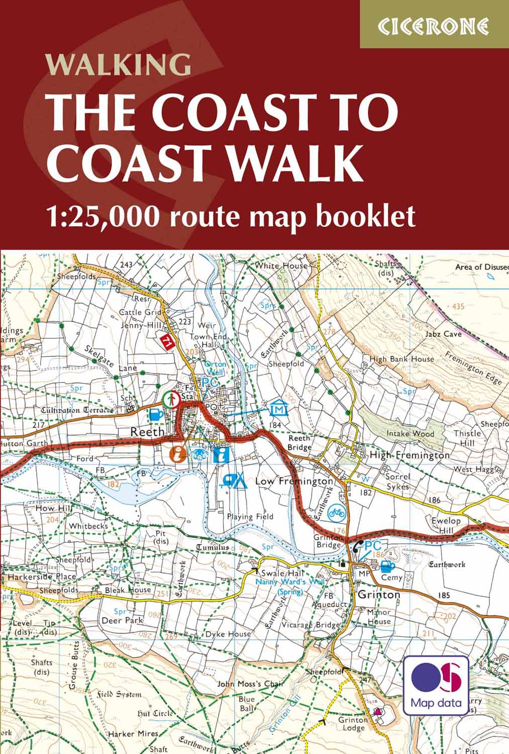
Product description: This map booklet shows the 190 mile (300km) Coast to Coast Walk, a popular long distance trail across northern England from St Bees Head in Cumbria to Robin Hood's Bay on the Yorkshire coast, devised by Alfred Wainwright. This booklet of Ordnance Survey 1:25,000 Explorer maps has been designed for convenient use on the Coast to Coast Walk and shows the full line of the trail along with the relevant extract from the OS Explorer map legend. It can be used when walking the route west–east or east–west. Conveniently sized for slipping into a jacket pocket or top of a rucksack, it comes in a clear PVC sleeve.
Seasons:
Accommodation along the Coast to Coast walk may be busy in summer and higher, more remote, parts difficult in winter. Spring or autumn is ideal.
Centres:
St Bees, Grasmere, Shap, Kirkby Stephen, Richmond, Ingleby Arncliffe, Grosmont, Whitby, Robin Hood's Bay.
Difficulty:
The C2C is a two-week route with total ascent of 6995m (22,825ft). Some remote stretches, especially walking on the North York Moors.
Must See:
The Lakeland fells, Swaledale, Vale of Mowbray, North York Moors, cliff-top walks at Robin Hood's Bay.
Locatie op kaart
Artikelen uit dezelfde regio

Wandelkaart Coast to Coast - Harvey maps • 9781851376186
Wandelkaart Coast to Coast - Keld to Robin Hood's Bay - Harvey maps Productomschrijving: Toont de gehele oostelijke helft van de route op één vel. Heeft betrekking op het gedeelte van Keld naar Robin Hood's Bay. Omvat alle alternatieve routes. Gedetailleerde kaart met aanvullende informatie en handige telefoonnummers. Nieuwe generatie HARVEY Superwalker, XT25 waterproof, werden ontworp…

Wandelgids Mardale and the Far East - Cicerone • 9781786310354
Wandelgids - Mardale and the Far East - Cicerone Productomschrijving: Deze gids maakt deel uit van de serie "Walking the Lake District Fells" en behandelt een breed scala aan routes naar 36 Lakeland-toppen die kunnen worden beklommen vanuit de valleien van Ullswater, Haweswater, Troutbeck, Kentmere en Longsleddale, met hoogtepunten zoals High Street, Place Fell en Kentmere fells. Suggestie…

Wandelgids Great Walks on the England Coast Path - Cicerone • 9781852849894
Great Walks on the England Coast Path - Cicerone Engelse omschrijving: At around 4500 km (2800 miles), the England Coast Path is the longest coastal trail in the world. This inspirational large-format guide presents a handpicked selection of 30 highlight sections, offering a taste of England's stunning and diverse shoreline. Routes range from 9 to 45km, spanning between 3 hours and 2 days,…

Wandelgids The Pennine Way - Cicerone • 9781852849061
Wandelgids - The Pennine Way - Cicerone Productomschrijving: De Pennine Way National Trail met OS kaart boekje. De route van de 320 km van Edale naar Kirk Yetholm duurt drie weken om te lopen en is geschikt voor fit en langeafstand ervaren wandelaars. De route doorkruist het Peak District NP, de Yorkshire Dales NP en de North Pennines nationale parken. Bevat afzonderlijk boekje van de rout…

Wandelgids Reivers Way through historic Northumberland- Cicerone • 9781852844981
Wandelgids- Reivers Way through historic Northumberland- Cicerone Productomschrijving: Een handige zakformaat handleiding voor iedereen die van plan is om de Reivers Way af te lopen. Volg in de voetstappen van de border reivers op deze 150 mijl lange route, die loopt van Corbridge naar Alnmouth. De reivers route dwaalt door wilde en schilderachtige delen van Northumberland, en kan worden g…