
Wandelkaart 101 Isles of Scilly- SW England - OSI
Isles of Scilly South West England
Korte omschrijving
Wandelkaart Isles of Scilly - SW England - Ordnance Servey. Productomschrijving: Isles of Scilly, South West England - Kaart nummer 101 is een all purpose kaart vol gepakt met informatie om ...

Specificaties
- Uitgever: Ordnance Survey
- ISBN-13: 9780319243039
- HOOFDCATEGORIEËN: Wandelkaart
- Activiteiten: Wandelen, Hiking & Trekking
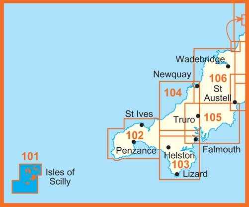
- Regio: Cornwall, England
- Land: England
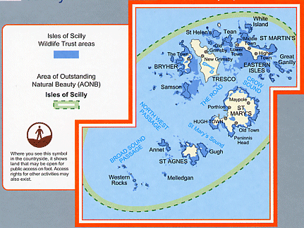
- AONB - Area of Outstanding Beauty: Isles of Scilly AONB
- Schaal: 1:25000
- Afmeting: 13x23
- Taal: Engels
- Reeks: Explorer Series
Volledige omschrijving
Wandelkaart Isles of Scilly - SW England - Ordnance Servey.
Productomschrijving: Isles of Scilly, South West England - Kaart nummer 101 is een all purpose kaart vol gepakt met informatie om u het gebied te helpen leren kennen. De 204 Landranger-kaarten bestrijken het land. Elke kaart heeft een oppervlakte van 40 km door 40 km (25 mijl door 25 mijl) en zoals andere kaarten van Ordnance Survey, National Grid-vierkanten worden verstrekt zodat elke functie een unieke referentienummer kan worden gegeven.
With hte Isle od Scilly Wildlife Trust Areas
101 / Isles of Scilly, South West England - These highly detailed maps show all the administrative boundaries, settlements as small as isolated farms, the road network down to unfenced roads and country tracks, and field boundaries (hedges and drystone walls) which make navigation across the countryside much easier. Steep gradients on roads are indicated. Various landmarks, e.g. powerlines, archaeological sites, windmills, churches and lighthouses are shown and additional graphics indicate natural terrain features such as cliffs, scree, mud and vegetation variations.
The contour interval is 5 metres in the lower parts of the country and 10 metres in the uplands, and spot heights are marked. Each map covers an area of 30 x 20km (i.e. approx. 19 x 12 miles), with some double-sided maps covering more, as indicated in the individual descriptions. The maps are fully GPS compatible, with the National Grid shown at 1km intervals and latitude and longitude indicated by margin ticks at 1'.

Locatie op kaart
Artikelen uit dezelfde regio

Reisgids Exploring Cornwall - Goldeneye • 9781859652978
Exploring Cornwall - Goldeneye Productomschrijving: Dit boek is anders. Het is een onafhankelijke stem, omdat alle inzendingen worden gekozen op verdienste, en verdienste, alleen. In een digitaal tijdperk waar (reis)informatie wordt verstrekt door reclamebudgetten. Hierbij een verfrissende en verhelderende kijk op wat Cornwall de bezoeker en inwoner te bieden heeft. Engelse omschrijvin…

Wandelgids Land's End Circuit Cornwall England - Rucksack Readers • 9781898481928
Wandelgids Land's End Circuit Cornwall England Productomschrijving: Het South West Coast Path is beroemd mooi, maar de langste National Trail van Groot-Brittannië is niet voor angsthazen. Velen worden afgeschrikt door de uitdaging van 630 mijl en 35.000 meter stijgen en dalen. Dus auteur Max Landsberg heeft een 5-daagse proeverij gemaakt, beginnend bij St-Ives om Penzance te bereiken via e…

Wandelgids The South West Coast Path - Cicerone Press • 9781786310682
The South West Coast Path - Cicerone Productomschrijving: Omvat spectaculaire plaatsen die dit deel van het Engelse landschap rijk is, zoals Exmoor National Park, met 5 AONB's of Areas of Outstanding Natural Beauty, de Jurassic Coast Natural World Heritage Site. Deze route bestaat al heel lang. De route start of eindigd natuurlijk in Minehead, in Somerset, loopt langs de kust richting de v…

Reisgids Devon & Cornwall - Rough Guides • 9780241270325
Reisgids Devon & Cornwall - Rough Guides Productomschrijving: The Rough Guide to Devon and Cornwall is the perfect companion to your trip to this captivating peninsula, introducing you to the charms of gentle, pastoral Devon and wild, craggy Cornwall. Both counties will tempt you outside to enjoy their mild climate, with everything from hikes over Dartmoor and surfing off Newquay to puffi…

Wandelkaart 204 Truro & Falmouth- Cornwall England - OSI • 9780319263969
Wandelkaart Truro & Falmouth- Cornwall - OSI Productomschrijving: In het uiterste zuidwesten van Engeland omvat de OS Landranger 204 van Truro & Falmouth ook St Austell, Dodman Point, Gillan, Penryn, Feock, Ladock, Trispen, Coldharbour, Portloe en een deel van het South West Coast Path. Cornwall trekt al eeuwenlang bezoekers, die onder de indruk zijn van het milde klimaat, de glooiende heu…