
Wandelkaart 809 Mammoth Lakes - Mono Divide - Nat Geo
Gelegen direct ten oosten van Mammoth Mountain
Korte omschrijving
TOPO Wandelkaart 809 - Mammoth Lakes - Mono Divide - National Geographic Productomschrijving: Mammoth Lakes is een stadje in Mono County, California, de enige geintegreerde community in de r...

Specificaties
- Uitgever: National Geographic
- ISBN-13: 9781566952668
- HOOFDCATEGORIEËN: Wandelkaart
- Regio: Californië, USA
- Land: Verenigde Staten van Amerika (USA)
- Schaal: 1:63360
- Afmeting: 10x19
- Taal: Engels
Volledige omschrijving
TOPO Wandelkaart 809 - Mammoth Lakes - Mono Divide - National Geographic
Productomschrijving: Mammoth Lakes is een stadje in Mono County, California, de enige geintegreerde community in de regio. Gelegen direct ten oosten van Mammoth Mountain.
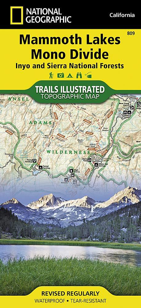
Engelse omschrijving: Explore the magnificent alpine landscape of Mammoth Lakes, Mono Divide with National Geographic's Trails Illustrated map. Expertly researched and created in partnership with local land management agencies, this map features key points of interest including John Muir, Ansel Adams, and Dinkey Lakes wilderness areas; Devils Postpile National Monument; and the northern portion of Kings Canyon National Park. Loaded with helpful information on wilderness camping, safety tips, and regulations, this map is an invaluable tool for casual visitors and avid adventurers alike.
The Mammoth Lakes, Mono Divide Trails Illustrated Map can guide you off the beaten path and back again with miles of mapped trails including portions of the Pacific Crest and John Muir trails. The trails are clearly marked for their usage, and mileage between intersections is noted. Road types are differentiated as well, so you know if the route you choose is a paved, dirt, four-wheel-drive, or high-clearance road. The map base includes contour lines and elevations for summits, passes and some lakes. A variety of recreation features are noted, including campgrounds, trailheads, interpretive trails, boat launch sites, horse pack stations, and more. Every Trails Illustrated map is printed on "Backcountry Tough" waterproof, tear-resistant paper. A full UTM grid is printed on the map to aid with GPS navigation.
Other features found on this map include: Ansel Adams Wilderness, Courtright Reservoir, Dinkey Lakes Wilderness, Inyo National Forest, John Muir Wilderness, Kings Canyon National Park, Lake Crowley, Lake Thomas A Edison, Mount Darwin, Mount Goddard, Mount Morgan, Mount Powell, Mount Ritter, Nelson Mountain, Ritter Range, Sierra National Forest.
.png)
Locatie op kaart
Overzichtskaarten

NAT GEO California trail maps
NAT GEO California trail maps

Producten op de overzichtskaart
Klik op een product om naar de detailpagina te gaan.
- Wandelkaart 205 Sequoia & Kings Canyon NP - California
- Wandelkaart 206 Yosemite NP - California - Nat Geo
- Wandelkaart 218 Redwood National & State Parks - Nat Geo
- Wandelkaart 221 Death Valley NP - Nevada - Natgeo
- Wandelkaart 226 Joshua Tree NP - California - Nat Geo
- Wandelkaart 256 Mojave National park California - Nat Geo
- Wandelkaart 306 Yosemite SW- Yosemite Valley - Nat Geo
- Wandelkaart 307 Yosemite NP North West - Nat Geo
- Wandelkaart 308 Yosemite NE- Tuolumne Meadows - Nat Geo
- Wandelkaart 309 Yosemite SE - Ansel Adams Wilderness - Nat Geo
- Wandelkaart 322 Mount Whitney California - Nat Geo
- Wandelkaart 803 Lake Tahoe Basin - California - Nat Geo
- Wandelkaart 804 Tahoe National Forest West - Nat Geo
- Wandelkaart 805 Tahoe Nat. Forest East - Sierra Buttes - Nat Geo
- Wandelkaart 809 Mammoth Lakes - Mono Divide - Nat Geo
- Wandelkaart 810 Shaver Lake - Sierra National Forest - Nat Geo
Artikelen uit dezelfde regio

Wandelkaart 1001 - John Muir Trail - Nat Geo • 9781566956895
TOPO Wandelkaart 1001 - John Muir Trail - National Geographic Productomschrijving: De John Muir Trail - is een langeafstandswandelpad in het Sierra Nevada-gebergte in de Amerikaanse staat Californië. Het is vernoemd naar de Schots-Amerikaanse natuurvorser en schrijver John Muir, die een cruciale rol speelde in de bescherming van de nationale parken van Californië. Het 338,6 kilometer lange…

Wandelkaart 812 Los Padres Nat. Forest East - Natgeo • 9781566955805
TOPO Wandelkaart 812 - Los Padres Nat. Forest East - Natgeo Productomschrijving: Los Padres National Forest is een bosgebied in Amerika, meerbepaald in oost- en centraal California. Het bos is uitermate gekend voor mountainbikers en hikers. Engelse omschrijving: One of the most diverse National Forests in the United States, Los Padres National Forest provides recreation opportunities f…

Reisgids San Francisco pocket guide - Lonely Planet • 9781787014114
San Francisco pocket guide - Lonely Planet Coverage Includes: Golden Gate Bridge, The Marina, Fisherman’s Wharf, North Beach, Chinatown, Downtown, SoMa, Hayes Valley, Civic Center, The Mission, The Haight, Golden Gate Park, and more Product description: Lonely Planet Pocket San Francisco is your passport to the most relevant, up-to-date advice on what to see and skip, and what hidden d…

Reisgids Los Angeles & Southern California - Rough Guides • 9781848365834
Reisgids Los Angeles & Southern California - Rough Guides Productomschrijving: The Rough Guide to Los Angeles & Southern California is the definitive guide to the region. Whether you're looking for inspiring accommodation or great places to eat, you'll find the solution with hundreds of restaurant, hotel, nightlife and shop reviews. Along with a thorough look at LA's top tourist areas, fro…

Reisgids San Diego - Top 10 - DK Eyewitness • 9780241367964
DK Eyewitness TOP 10 - San Diego California Omvat: Downtown, Old Town, Uptown, Mission Valley, Ocean Beach & Coronado. Productomschrijving: Verken de prachtige tuinen van Balboa Park, bezoek de beroemde San Diego Zoo, wandel langs de Embarcadero naar het historische tallship Star of India, of geniet van het nautische erfgoed van de stad in het Maritiem Museum. Van de Top 10 tuinen en n…