
Coast to coast through wild Northumberland's border country
Cycling the Reivers Route - Whitehaven naar Tynemouth

Korte omschrijving
Through wild Northumberland's border country - Cicerone Productomschrijving: Als de wildste van de noordelijke kust-tot-kust fietsroutes verkent de Reivers Route de rijke geschiedenis van de...

Specificaties
- Uitgever: CICERONE Press
- ISBN-13: 9781852849108
- HOOFDCATEGORIEËN: Wandelgids
- Activiteiten: Fietsen / VTT / MTB
- Auteur: Carl Mc-keating, Rachel Crolla
- Regio: Northhumberland, North England
- Land: England
- Blz.: 128, 144
- Afmeting: 12x17
- Editie: 1
- Taal: Engels
Volledige omschrijving
Through wild Northumberland's border country - Cicerone
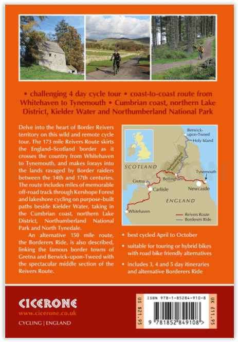
Productomschrijving: Als de wildste van de noordelijke kust-tot-kust fietsroutes verkent de Reivers Route de rijke geschiedenis van de Border Reiving in Noord-Engeland en de Schotse Borders. Deze vierdaagse fietstocht van 280 km van Whitehaven naar Tynemouth voert langs de kust van Cumbria, het noordelijke Lake District, het Northumberland National Park en North Tynedale, en biedt onvergetelijke off-road fietstochten door Kershope Forest en rond Kielder Water. De route biedt zowel on- als off-road fietsen, en is geschikt voor fietsers met een tourfiets of hybride fiets. Plaatsen om te overnachten zijn Carlisle, Bailey Mill en Bellingham.
De gids biedt ook de Borderers Ride, een alternatieve kust-tot-kust tocht langs de grens tussen Engeland en Schotland, van Gretna naar Berwick-upon-Tweed. Deze route voegt het fantastische middelste deel van de Reivers Route samen met een route naar het noorden via Wooler en het heilige eiland Lindisfarne om te eindigen in Berwick-upon-Tweed. Of het nu gaat om de Reivers Route of de Borderers Ride, deze fietstochten bieden uitzonderlijke fietsmogelijkheden op omheinde wegen en rustige fietspaden terwijl ze glooiende hellingen, afgelegen bossen en tal van historische plaatsen verkennen.
Engelse omschrijving: As the wildest of the northern coast-to-coast cycle routes, the Reivers Route explores the rich Border Reiving history of northern England and the Scottish Borders. Travelling 173 mile (280km) from Whitehaven to Tynemouth, this four-day cycle tour takes in the Cumbrian coast, northern Lake District, Northumberland National Park and North Tynedale, offering memorable off-road cycling through Kershope Forest and around Kielder Water. The route offers both on and off-road cycling, and is suitable for cyclists using touring or hybrid bikes. Places to stay overnight include Carlisle, Bailey Mill and Bellingham.
The guidebook also offers the Borderers Ride, an alternative coast-to-coast ride along the England-Scotland border from Gretna to Berwick-upon-Tweed. This route joins up the fantastic middle section of the Reivers Route with a route heading north via Wooler and the Holy Island of Lindisfarne to finish at Berwick-upon-Tweed. Whether on the Reivers Route or the Borderers Ride, these cycle tours offer exceptional cycling on gated roads and quiet cycle paths as they explore rolling hillsides, remote forests and plenty of historic sites.
This guidebook provides everything you need to enjoy a successful cycle tour on the Reivers Route or Borderers Ride. Each stage includes detailed 1:100,000 mapping, profiles and comprehensive route description containing insights into points of interest along the way. The introduction offers plenty of information about the area's history, as well as practical advice about suitable bikes, equipment, and transport to and from the route. The appendices feature useful contacts for bike shops and available accommodation.

Artikelen uit dezelfde regio

Wandelkaart Hadrian's Wall Path - Harvey maps • 9781851374380
Wandelkaart Hadrian's Wall Path - Harvey maps Productomschrijving: Kaart van de gehele Hadrians Way op één kaart. 130km (81 mijl) van de Solway Coast naar Newcastle. Met de gelegenheid voor een bezoek aan een groot aantal historische plekken langs de weg. Informatie over het vinden van accommodatie, camping, voedsel. Met routebeschrijving naar de start van de route. Nieuwe generatie H…

Wandelkaart 87 Hexham & Haltwhistle- England - OSI • 9780319261859
Wandelkaart Hexham & Haltwhistle - England Productbeschrijving: OS Landranger kaart 87 van Hexham & Zeist omvat ook Langley, Allenheads, Ramshaw, Stocksfield, Haydon Bridge, Hallington, Wark, deel van Hadrian's wall pad, deel van de Pennine Way en deel van Northumberland National Park. De OS Landranger kaarten reeks heeft betrekking op Groot-Brittannië met 204 gedetailleerde kaarten, p…

Wandelkaart 185 Newcastle & Emly Northumberland - OSI • 9780319243787
Wandelkaart Newcastle & Emlyn - Northumberland England Omvat ook: Llandysul & Cynwyl Elfed Productomschrijving: Kaart nummer 185 omvat Newcastle Emlyn, Llandysul & Cynwyl. Hoogtepunten zijn Afon Teifi en de Teifi Valley Railway. Ook Llechryd, Rhos, Bronwydd wapens en Cymbach. De OS Explorer kaart voor Newcastle Emlyn is beschikbaar in zowel de standaard papieren versie en weerbestendig…

Wandelkaart 87 Hexham & Haltwhistle England - OSI • 9780319474105
Wandelkaart Hexham & Haltwhistle - England Productbeschrijving: OS Landranger kaart 87 van Hexham & Zeist omvat ook Langley, Allenheads, Ramshaw, Stocksfield, Haydon Bridge, Hallington, Wark, deel van Hadrianus Wall pad, deel van de Pennine Way en deel van Northumberland National Park. De OS Landranger kaarten reeks heeft betrekking op Groot-Brittannië met 204 gedetailleerde kaarten, perfe…

Wandelkaart 316 Newcastle upon Tyne Northumberland - OSI • 9780319245682
Wandelkaart Newcastle upon Tyne - Northumberland England Omvat ook: Gateshead, South Shields, Prudhoe, Ponteland, Cramlington & Whitley Bay Productomschrijving: Kaart nummer 316 in de OS Explorer kaarten reeks omvat de levendige en bruisende stad van Newcastle-upon-Tyne en de omringende gebieden. Hoogtepunten van het gebied zijn onder meer: het oostelijke gedeelte van Hadrian's Wall, d…