
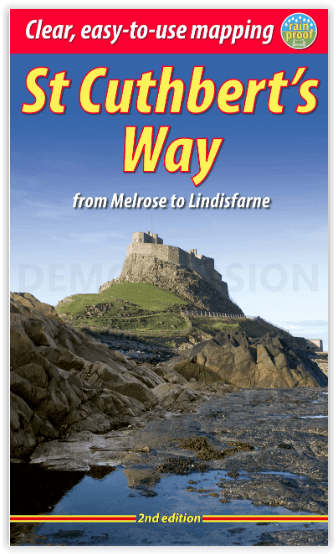
Wandelgids St-Cuthbert's Way Schotland - Rucksack Readers
From Melrose Abbey to the Holy Island of Lindisfarne - 101 km
Korte omschrijving
St-Cuthbert's Way Schotland - Rucksack Readers Productomschrijving: Volg in de voetsporen van St Cuthbert in deze gemakkelijke wandeling van 101 km, van Melrose Abbey in de Schotse Borders n...

Specificaties
- Uitgever: RUCKSACK READERS
- ISBN-13: 9781913817138
- HOOFDCATEGORIEËN: Wandelgids
- Activiteiten: Wandelen, Hiking & Trekking
- Auteur: Ronald Turnbull
- Regio: Northumberland, Engeland, Schotse grenzen
- Land: England, Schotland
- Lange afstand wandelroutes: St Cuthbert's Way (102 km)
- Blz.: 72
- Schaal: 1:100000
- Afmeting: 13x22
- Editie: 2
- Taal: Engels
Volledige omschrijving
St-Cuthbert's Way Schotland - Rucksack Readers
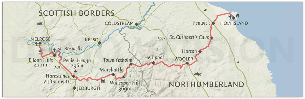
Productomschrijving: Volg in de voetsporen van St Cuthbert in deze gemakkelijke wandeling van 101 km, van Melrose Abbey in de Schotse Borders naar het Heilige Eiland Lindisfarne in Northumberland. St Cuthbert's Way is een van de Great Trails van Schotland en ook een van de Great Trails van Engeland. De route begint bij de ruïnes van Melrose Abbey, slingert langs de rivier de Tweed, en na ongeveer 31 mijl loopt u over de grens naar Engeland op hooggelegen terrein. De route omvat een deel van de Romeinse weg en passeert onderweg kastelen, heuvelforten en historische ruïnes. De meeste mensen kunnen de route gemakkelijk in 5 of 6 dagen afleggen.
Engelse omschrijving: Follow the footsteps of St Cuthbert in this easy-going walk of 63 miles (101 km) from Melrose Abbey in the Scottish Borders to the Holy Island of Lindisfarne in Northumberland. St Cuthbert’s Way is one of Scotland’s Great Trails, and it is also one of England’s great trails. Starting from the ruins of Melrose Abbey, it winds alongside the River Tweed, and after about 31 miles you walk across the border into England on high ground. The Way includes a section of Roman road and passes castles, hill forts and historic ruins along the way. Most people will complete it comfortably within 5 or 6 days.
Its summit is Wideopen Hill (369m/1210ft), and its barefoot finale is the Pilgrim Way to Lindisfarne with its priory and castle. The route is fully waymarked, the gradients are modest and it has welcoming B&Bs and pubs at strategic intervals. This second edition was thoroughly revised in 2023 and it contains custom mapping at 1:40,000 and many post-Covid updates. It is bound in our lighter, pocket-friendly format and printed on rainproof paper.
This guidebook has all you need to plan and enjoy the St Cuthbert’s Way:
- concise directions updated in 2023
- background on St Cuthbert’s life and times
- features on Lindisfarne, history and wildlife
- contact details for accommodation and transport
- detailed mapping on 16 pages (1:40,000)
- 100 glorious colour photos
- rainproof, rucksack-friendly format.
Locatie op kaart
Artikelen uit dezelfde regio

Wandelkaart 340 Active - Holy Island & Bamburgh - OSI • 9780319475768
Wandelkaart Holy Island & Bamburgh - Explorer Active Productomschrijving: Holy Island en Bamburgh zijn 2 aan de kust liggende eilanden/archipel die de interesse trekt van velen in het teken van natuur bezoek, wandelen of fietsen. De locatie is zeer mooi wat de natuur betreft. Omvat: Cheswick, Ancroft, Haggerston, Bowsden, Beal, Fenwick, Holy Island, Holburn, Doddington, Belford, Waren …

Wandelkaart 339 Kelso Coldstream & lower Tweed Valley - OSI • 9780319472118
Wandelkaart Kelso- Coldstream & lower Tweed Valley - Schotland Omvat ook de lower Tweed Valley Productbeschrijving: Kaart nummer 339 dekt Kelso en Coldstream. Hoogtepunten zijn Northumberland National Park & de Borders Abbeys Way. Omvat ook de rivier Tweed, Newtown St. Boswells, Norham en Doddington. De OS Explorer kaart voor Kelso, Coldstream & lagere Tweed Vallei is beschikbaar in zo…

Wandelkaart Northumberland - Harvey Maps • 9781851376681
Wandelkaart Northumberland - Harvey Maps Productomschrijving: De Gehele route op één kaart! - Het Northumberland Coast Path strekt zich uit over 103 km van Cresswell in het zuiden naar Berwick-upon-Tweed in het noorden, waarna het Berwickshire Coastal Path 48 km (28 m) verdergaat naar Cockburnspath. Beide routes staan op deze kaart en ze maken deel uit van het Noordzeepad. Het Northumb…

Wandelkaart XT25 Cheviot Hills - Harvey Maps • 9781851376094
Wandelkaart Cheviot Hills - Harvey Maps Productomschrijving: Ideaal voor The Cheviot, Windy Gyle en het noordelijke deel van Northumberland National Park. Omvat: Wooler, Kirk Yetholm, Breamish Valley en Harthope Valley - Lichtgewicht, gedetailleerd, duidelijk en makkelijk te lezen - Geprint op sterk, 100% watervast en scheurbestendig papier - Toont de horeca voor na je dagtrip …

Wandelgids St Cuthbert's Way - Cicerone • 9781786311566
Wandelgids St Cuthbert's Way - Cicerone Productomschrijving: Deze wandelgids beschrijft de lange afstand St Cuthbert's Way door het ongerepte landschap van Northumberland en de Borders. De 100 km lange route begint in Melrose en doorkruist de ruige rotsen en heidevelden van de Cheviot Hills, gaat door het Northumberland National Park naar het sfeervolle Lindisfarne (Holy Island). De tocht …