
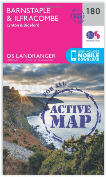
Wandelkaart 180 Barnstaple & Ilfracombe- Devon England - OSI
Omvat de Northern Coast of Devon- on the Bristol Channel
Korte omschrijving
Wandelkaart Barnstaple & Ilfracombe- Lynton - North Devon Productbeschrijving: Kaart nummer 180 is een all purpose kaart vol gepakt met informatie om u het gebied te helpen leren kennen. De ...

Specificaties
- Uitgever: Ordnance Survey
- ISBN-13: 9780319475034
- HOOFDCATEGORIEËN: Wandelkaart
- Activiteiten: Wandelen, Hiking & Trekking
- Regio: Devon, England
- Land: England
- Waterafstotende kaart: Ordnance Survey ACTIVE Landranger Weatherproof Maps
- Schaal: 1:50000
- Afmeting: 13x23
- Taal: Engels
- Reeks: Landranger ACTIVE series OSI
Volledige omschrijving
Wandelkaart Barnstaple & Ilfracombe- Lynton - North Devon
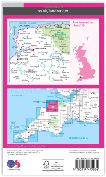
Productbeschrijving: Kaart nummer 180 is een all purpose kaart vol gepakt met informatie om u het gebied te helpen leren kennen. De 204 Landranger-kaarten bestrijken het land. Elke kaart heeft een oppervlakte van 40 km door 40 km (25 mijl door 25 mijl) en zoals andere kaarten van Ordnance Survey, National Grid-vierkanten worden verstrekt zodat elke functie een unieke referentienummer kan worden gegeven. Barnstaple is een plaats (town) in het bestuurlijke gebied North Devon, in het Engelse graafschap Devon.
Productdiscription: The OS Landranger Active Map series covers Great Britain with 204 detailed maps, perfect for day trips and short breaks. Tough, durable and weatherproof, covered in a lightweight protective plastic coating that can be written on, so that your favourite routes can be easily highlighted. Each map provides all the information you need to get to know your local area and includes places of interest, tourist information, picnic areas and camp sites, plus Rights of Way information for England and Wales. OS Landranger Active now includes a digital version of the paper map, accessed through the OS smartphone app, OS Maps.

Locatie op kaart
Overzichtskaarten

OSI Landranger & Landranger Active - Land's End - Devon - Cornwall
OSI Landranger & Landranger Active - Land's End - Devon - Cornwall

Producten op de overzichtskaart
Klik op een product om naar de detailpagina te gaan.
- Wandelkaart 180 Barnstable & Ilfracombe- Devon England - OSI
- Wandelkaart 180 Barnstaple & Ilfracombe- Devon England - OSI
- Wandelkaart 181 Minehead & Brendon Hills- England - OSI
- Wandelkaart 181 Minehead & Brendon Hills- England - OSI
- Wandelkaart 182 Weston-super-Mare & Bridgwater- England - OSI
- Wandelkaart 182 Weston-super-Mare- Somerset England - OSI
- Wandelkaart 190 Bude & Clovelly- Cornwall England - OSI
- Wandelkaart 190 Bude- Clovelly & Boscastle - OSI
- Wandelkaart 191 Okehampton & North Dartmoor NP - OSI
- Wandelkaart 191 Okehampton & North Dartmoor NP - OSI
- Wandelkaart 192 Exeter & Sidmouth- Devon - OSI
- Wandelkaart 192 Exeter- Sidmouth & Exmouth - OSI
- Wandelkaart 193 Taunton & Lyme Regis- England - OSI
- Wandelkaart 193 Taunton & Lyme Regis- Somerset - OSI
- Wandelkaart 200 Newquay- Bodmin & Camelford - OSI
- Wandelkaart 200 Newquay & Bodmin Cornwall - OSI
- Wandelkaart 201 Plymouth & Launceston England - OSI
- Wandelkaart 201 Plymouth & Launceston England - OSI
- Wandelkaart 202 Torbay - South Dartmoor NP - OSI
- Wandelkaart 202 Torbay & South Dartmoor - OSI
- Wandelkaart 204 Truro- Falmouth & Roseland - OSI
- Wandelkaart 203 Land's End & Isles of Scilly - OSI
- Wandelkaart 203 Land's End & Isles of Scilly - OSI
- Wandelkaart 204 Truro & Falmouth- Cornwall England - OSI
Artikelen uit dezelfde regio

Wandelgids SWCP part 3 - Dorset & South Devon - Trailblazer • 9781912716340
Wandelgids SWCP part 3 - Dorset & South Devon - Trailblazer Productomschrijving: Dorset & South Devon Coast Path (South-West Coast Path Part 3) This guide covers the third and last section of the South West Coast Path, from Plymouth to Poole Harbour (217 miles). This beautiful route includes 95 miles within England’s only Natural World Heritage Site, the Jurassic Coast, and passes dram…

Reisgids Devon & Cornwall - Rough Guides • 9780241270325
Reisgids Devon & Cornwall - Rough Guides Productomschrijving: The Rough Guide to Devon and Cornwall is the perfect companion to your trip to this captivating peninsula, introducing you to the charms of gentle, pastoral Devon and wild, craggy Cornwall. Both counties will tempt you outside to enjoy their mild climate, with everything from hikes over Dartmoor and surfing off Newquay to puffi…

Wandelkaart XT40 Dartmoor NP Zuid - Harvey Maps • 9781851376339
Wandelkaart XT40 Ultra - Dartmoor NP Zuid - Harvey Maps Productomschrijving: De kaart omvat een groot gebied maar is wel zeer praktisch en compact, en in zakformaat. Deze gedetailleerde wandelkaart is bestemd voor lopers en wandelaars van het zuidelijk deel van Dartmoor National Park. Omvat eveneens Dartmoor's bekende Tors waaronder Great Staple Tor & Ugborough Beacon. Met archaeologische …

Reisgids Devon & Cornwall - Lonely Planet • 9781838697266
Reisgids Devon & Cornwall - Lonely Planet Productomschrijving: Welkom in het wilde westen - een land van met brem begroeide kliffen, dreunende branding, wit zand en epische, weidse luchten. Lonely Planet brengt je naar het hart van Devon & Cornwall, met geweldige reiservaringen en het beste planningsadvies. Lonely Planet Devon & Cornwall is jou paspoort voor het meest relevante, actuel…

Wandelkaart 180 Barnstable & Ilfracombe Devon England - OSI • 9780319262788
Wandelkaart Barnstable & Ilfracombe - Devon England Productbeschrijving: Kaart nummer 180 is een all purpose kaart vol gepakt met informatie om u het gebied te helpen leren kennen. De 204 Landranger-kaarten bestrijken het land. Elke kaart heeft een oppervlakte van 40 km door 40 km (25 mijl door 25 mijl) en zoals andere kaarten van Ordnance Survey, National Grid-vierkanten worden verstrekt …