
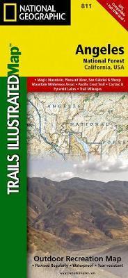
Wandelkaart 811 Angeles National Forest - Natgeo
Een bosgebied in de onmiskenbare San Gabriel Mountains
Korte omschrijving
Wandelkaart Angeles National Forest, California USA (9781566955775) National Geographic Productomschrijving: Een bosgebied in de onmiskenbare San Gabriel Mountains in het zuiden van de Ameri...

Specificaties
- Uitgever: National Geographic
- ISBN-13: 9781566955775
- HOOFDCATEGORIEËN: Wandelkaart
- Regio: Californië, USA
- Land: Verenigde Staten van Amerika (USA)
- Regionale parken: Angeles National Forest, California
- Schaal: 1:80000
- Afmeting: 10x19
- Taal: Engels
Volledige omschrijving
Wandelkaart Angeles National Forest, California USA (9781566955775) National Geographic
Productomschrijving: Een bosgebied in de onmiskenbare San Gabriel Mountains in het zuiden van de Amerikaanse staat Californië. Het bestaat uit twee delen die van elkaar gescheiden worden door de Soledad Canyon. Het Angeles National Forest reikt tot net over de grens met San Bernardino County in het oosten en Ventura County in het westen. Het hoofdkwartier van de Forest Service in het Angeles National Forest is in Arcadia.
Omschrijving uitgever: Topographic Map National Geographic's Trails Illustrated map of Angeles National Forest provides both unmatched detail and valuable information for outdoor enthusiasts enjoying this diverse recreational area just north of Los Angeles. Expertly researched and created in partnership with the U.S. Forest Service, California State Parks and others, this map features key points of interest in the forest including Magic Mountain, Pleasant View Ridge, San Gabriel, Cucamonga and Sheep Mountain Wilderness Areas; San Gabriel Mountains; Pyramid Lake; and Piru Creek Wild and Scenic River.
Also included are nearby California State Parks: Antelope Valley California Poppy Reserve, Ripley Desert Woodland, Castaic Lake State Recreation Area, Hungry Valley State Vehicular Recreation Area and Placerita Canyon. Get off the beaten path and back on again by following the map along precisely mapped trails, labeled with mileage markers and color-coded according to designated use, whether hiking, mountain biking, ATVing or horseback riding.

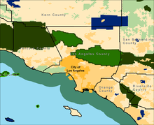
Locatie op kaart
Artikelen uit dezelfde regio

Reisgids USA Southwest & National Parks - DK Eyewitness • 9780241365519
USA Southwest & National Parks Omvat: Arizona, Las Vegas, Southern Utah, the Four Corners & New Mexico. Productomschrijving: Staar naar de diepten van de Grand Canyon, ervaar de glitter en glamour van de Las Vegas strip, beklim de rotsachtige overspanningen van Arches National Park of wandel door het historische Santa Fe: alles wat u moet weten is overzichtelijk weergegeven in kleurgec…

Wandelkaart 252 Channel Islands National Park - Nat Geo • 9781566954105
Channel Islands National Park - Nat Geo Productomschrijving: De Channel Islands Nationaal Park, gelegen voor de kust van Californië, zijn de thuisbasis van vele unieke soorten flora en fauna. National Geographic's Trails Illustrated kaart van Channel Islands National Park bestrijkt met ongeëvenaard detail de vijf eilanden die het park omvat, inclusief The Nature Conservancy gebied van Sant…

Wandelkaart 1001 - John Muir Trail - Nat Geo • 9781566956895
TOPO Wandelkaart 1001 - John Muir Trail - National Geographic Productomschrijving: De John Muir Trail - is een langeafstandswandelpad in het Sierra Nevada-gebergte in de Amerikaanse staat Californië. Het is vernoemd naar de Schots-Amerikaanse natuurvorser en schrijver John Muir, die een cruciale rol speelde in de bescherming van de nationale parken van Californië. Het 338,6 kilometer lange…

Reisgids San Francisco & Northern California - DK Eyewitness • 9780241360071
San Francisco & Northern California Omvat: Presidio, Pacific Heights and the Marina, Fisherman's Wharf and North Beach, Chinatown and Nob Hill, Financial District and Union Square, Civic Center, Haight Ashbury and the Mission, Golden Gate Park and Land's End, and sights beyond the city, plus major parts of Northern California including Carmel, Mendocino, Napa Wine Country, Lake Tahoe & Yos…

Wandelgids Toptrails - Nordamerika West - Rother • 9783763331857
Toptrails - Nordamerika West - Rother Productomschrijving: De uitgestrekte gebieden van het Amerikaanse Westen herbergen een grote verscheidenheid aan buitengewone natuurlandschappen. De bekendste werden al vroeg beschermd als de eerste nationale parken op aarde. Uitstekend ontwikkelde bezoekersfaciliteiten maken de spectaculaire bergen, kusten en woestijnen gemakkelijk toegankelijk voor i…