
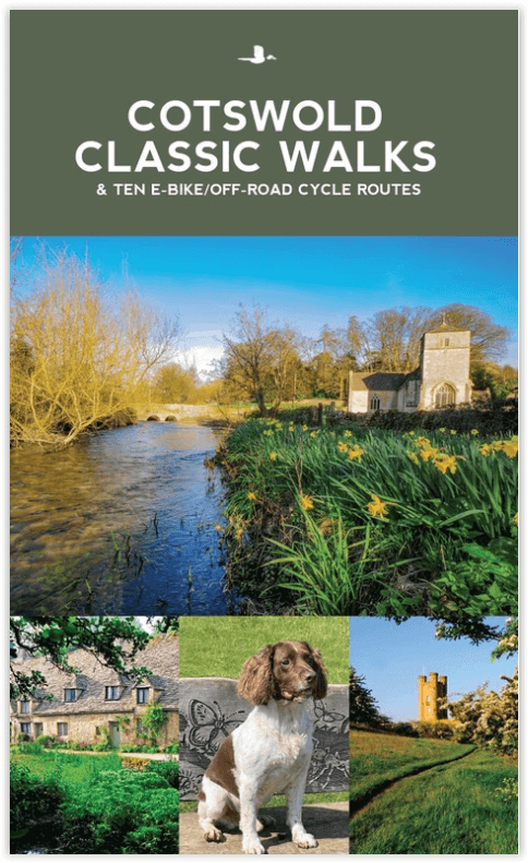
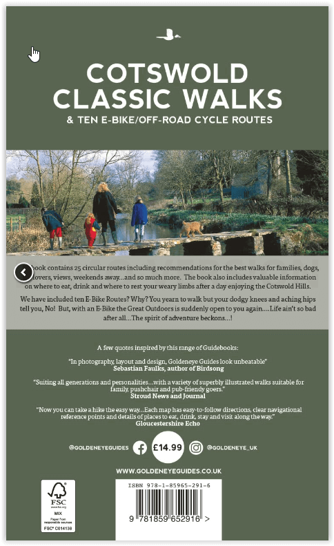
Wandelgids Cotswold Classic Walks - Goldeneye
Met 25 rondwandelingen - AONB regio
Korte omschrijving
Cotswold Classic Walks - Goldeneye Productomschrijving: Met 25 rondwandelingen helpt dit boek u een uitvalsbasis te vinden om de auto te ontvluchten en te genieten van een weekend vol frisse...

Specificaties
- Uitgever: Goldeneye
- ISBN-13: 9781859652916
- HOOFDCATEGORIEËN: Fietsgids
- Activiteiten: Wandelen, Hiking & Trekking
- Auteur: William Fricker
- Regio: Oxfordshire west England, Somerset South West England, Warwickshire, West Midlands, Wiltshire, West England, Worcestershire, West England
- Land: England
- AONB - Area of Outstanding Beauty: Cotswolds AONB
- Blz.: 136
- Afmeting: 13x22
- Editie: 4
- Taal: Engels
Volledige omschrijving
Cotswold Classic Walks - Goldeneye
Productomschrijving: Met 25 rondwandelingen helpt dit boek u een uitvalsbasis te vinden om de auto te ontvluchten en te genieten van een weekend vol frisse lucht en beweging....
Sommige wandelingen bieden verschillende routemogelijkheden en links naar andere wandelingen. Hoe beslist u welke wandeling u gaat doen? - Waar zijn de mooiste uitzichten? - Waar vind je eenzaamheid? - Dit boek helpt u een wandeling te vinden die bij u past, of het nu gaat om een wandeling met de kinderwagen, met het gezin, met de hond, door het bos, met bluebell of een kroegentocht. De kaarten zijn duidelijk, en zelfs als u kaarten moeilijk te lezen vindt, zullen de instructies u door de wandeling loodsen.
Engelse omschrijving: With 25 circular walks, this book will help you find a base to escape from your car and enjoy a weekend of fresh air and exercise....
Some walks offer various route options and links to other walks. How do you decide which walk to undertake? Where are the best views? Where to find solitude? This book will guide you to find a walk that suits you, whether it be a pushchair, family, dog, woodland, bluebell or a pub crawl. The maps are clear, and even if you find maps difficult to read, the instructions will get you round the walk.
Locatie op kaart
Overzichtskaarten

Area's of Outstanding Natural Beauty - AONB's UK
Area's of Outstanding Natural Beauty - AONB's UK

Producten op de overzichtskaart
Klik op een product om naar de detailpagina te gaan.
- Wandelgids - Guide to the Cotswolds AONB - AA
- Wandelkaart 24 - Chilterns AONB - AA
- Fietskaart- en Mtb kaart - The Cotswolds - Goldeneye
- Wandelgids - Cotswold classic walks guidebook - Goldeneye
- Wandelkaart - Cotswold South AONB - Goldeneye
- Wandelgids - Exploring the Cotswolds - Goldeneye
- Wandelgids - Cotswold Classic Walks - Goldeneye
- Wandelkaart - Cotswolds- Malverns & Forest of Dean - Goldeneye
- Wandelgids - The Cotswold Way 30 classic routes - Cicerone
- Wandelgids - Kent walking guide - Cicerone
- Wandelgids - North Downs Way Nat. trail - Cicerone
- Wandelgids - Chilterns walking guide - Cicerone
- Wandelgids - Suffolk coast & Heaths walks - Cicerone
- Wandelgids - North Downs Way - Map Booklet - Cicerone
- Wandelgids - North Pennines AONB walking guide - Cicerone
- Wandelgids - Ridgeway National Trail - Cicerone
- Wandelgids - Forest of Bowland & Pendle - Cicerone
- Wandelgids - Hampshire's Test Way walking guide - Cicerone
- Wandelgids & Fietsgids - The Cotswold AONB - Cicerone
- Wandelgids - Walking on the Gower - Cicerone
- Wandelgids - North Wessex Downs - Cicerone Press
- Wandelgids - Walking on the North Wessex Downs - Cicerone
- Wandelgids - Silverdale & Arnside AONB - Cicerone
- Wandelgids - The Kennet and Avon Canal walking guide - Cicerone
- Wandelgids - North Downs Way- 246 km - Trailblazer
- Wandelkaart OL2 - Yorkshire Dales- Southern & Western Areas - OSI
- Wandelkaart OL19 - Howgill Fells and Upper Eden Valley - OSI
- Wandelkaart OL21 - South Pennines - Yorkshire - OSI
- Wandelkaart OL31 - North Pennines- Teesdale & Weardale - OSI
- Wandelkaart OL40 - The Broads - OSI
- Wandelkaart OL41 - Forest of Bowland & Ribblesdale - OSI
- Wandelkaart OL45 - The Cotswolds AONB- Gloucestershire - OSI
- Wandelkaart 108 - Lower Tamer Valley & Plymouth- Cornwall- OSI
- Wandelkaart 115 - Exmouth & Sidmouth- Devon - OSI
- Wandelkaart 137 - Ashford- Kent downs AONB- England - OSI
- Wandelkaart 140 - Quantock Hills AONB- Somerset - OSI
- Wandelkaart 140 - Quantock Hills AONB & Bridgwater- Devon - OSI
- Wandelkaart 147 - Sevenoaks & Tonbridge- Kent - OSI
- Wandelkaart 164 - Gower AONB & Gwyr- South Wales - OSI
- Wandelkaart 164 - Gower AONB & Gwyr- Wales - OSI
- Wandelkaart 171 - Chiltern Hills West & Henley-on-Thames OSI
- Wandelkaart 171 - Chiltern Hills West AONB- Wycombe - OSI
- Wandelkaart 172 - Chiltern Hills East AONB- Wycombe - OSI
- Wandelkaart 181 - Chiltern Hills AONB North- England - OSI
- Wandelkaart 181 - Chiltern Hills North AONB- Wycombe - OSI
- Wandelkaart 190 - Malvern Hills & Bredon Hill - OSI
- Wandelkaart 190 - Malvern Hills AONB & Bredon Hill - OSI
- Wandelkaart 203 - Ludlow- Shropshire Hills AONB - OSI
- Wandelkaart 217 - Long Mynd & Wenlock Edge- Schropshire- OSI
- Wandelkaart 254 - Lleyn Peninsular East- North Wales - OSI
- Wandelkaart 261 - Boston- Lincolnshire AONB - OSI
- Wandelkaart 262 - Anglesey West- Wales AONB - OSI
- Wandelkaart 263 - Anglesey East AONB- Wales - OSI
- Wandelkaart 273 - Lincolnshire Wolds South AONB - OSI
- Wandelkaart 282 - Lincolnshire Wolds North AONB - OSI
- Wandelkaart 298 - Nidderdale AONB- Yorkshire - OSI
- Wandelkaart 298 - Nidderdale AONB North Yorkshire - OSI
- Wandelkaart 300 - Howardian Hills AONB - OSI
- Wandelkaart 300 - Howardian Hills AONB & Malton - OSI
- Wandelkaart - Mourne Mountains N. Ireland - Harvey maps
- Wandelkaart - Fietskaart Forest of Bowland - Harvey maps
- Wandelkaart XT40 - Anglesey Coastal Path N. Wales - Harvey Maps
- Wandelkaart XT40 - Pennine Way Noord - Harvey Maps
- Wandelkaart XT40 - Pennine Way Zuid - Harvey Maps
- Wandelgids Cotswold - Way Two-way trekking guide - Knife Edge
- Reisgids Oxford & the Cotswolds AONB - Edicola
- Reisgids Cotswolds England - Rough Guides
- Reisgids Go Slow- Sussex & the South Downs- Weald & Coast - Bradt
- Travelguide Oxford & The Cotswolds pocket guide - Lonely Planet
- Wandelgids - The Ridgeway National trail - Trailblazer
Artikelen uit dezelfde regio

Reisgids Oxford en quelques jours - Lonely Planet • 9782816179231
Reisgids Oxford en quelques jours - LP Déscription de produits: Un guide tout en couleurs, concis et ultrapratique pour découvrir Oxford et les Cotswolds Un guide complet permettant de combiner la découverte d’Oxford et l’exploration des Cotswolds AONB, l’une des plus belles campagnes d’Angleterre, aux portes de la ville Un découpage par quartier de la célèbre ville universitaire avec …

Wandelkaart 193 Taunton & Lyme Regis- Somerset - OSI • 9780319262917
Wandelkaart Taunton & Lyme Regis - Somerset England Productbeschrijving: OS Landranger kaart 193 toont delen van Devon, Dorset en Somerset, met inbegrip van de populaire vakantiebestemmingen steden van Taunton, Lyme Regis en Honiton. Leuke dingen om te zien de stad molen in Lyme Regis, opnemen met een waterrad werkende hersteld. De OS Landranger kaarten reeks heeft betrekking op Groot-…

Wandelkaart XT Malvern Hills AONB England - Harvey map • 9781851376056
Wandelkaart - Malvern Hills AONB England - Harvey map Productomschrijving: Deze Mavern Hills zijn een samenstelling van heuvels in de Engelse counties, Worcestershire, Herefordshire, en een klein deel van Gloucestershire, en domineren de volledige regio rond deze counties van het district van Alvern Hills. Het hoogst gelegen punt van deze regio biedt een panorama van de Severn vallei met d…

Reisgids Cotswolds England - Rough Guides • 9780241308752
Reisgids Cotswolds England - Rough Guides Productomschrijving: The Rough Guide to the Cotswolds AONB is your definitive handbook to one of the most beautiful and diverse holiday destinations in the UK. From stately homes and wildlife parks to modern art galleries, country walks and adventure sports, there is a section that introduces all of the regions’ highlights. For every town and v…

Wandelkaart 193 Taunton & Lyme Regis- England - OSI • 9780319475164
Wandelkaart Taunton & Lyme Regis - Somerset England Productbeschrijving: OS Landranger kaart 193 toont delen van Devon, Dorset en Somerset, met inbegrip van de populaire vakantiebestemmingen zoals de steden van Taunton, Lyme Regis en Honiton. Leuke dingen om te zien de stad molen in Lyme Regis, opnemen met een waterrad werkende hersteld. De OS Landranger kaarten reeks heeft betrekking …