
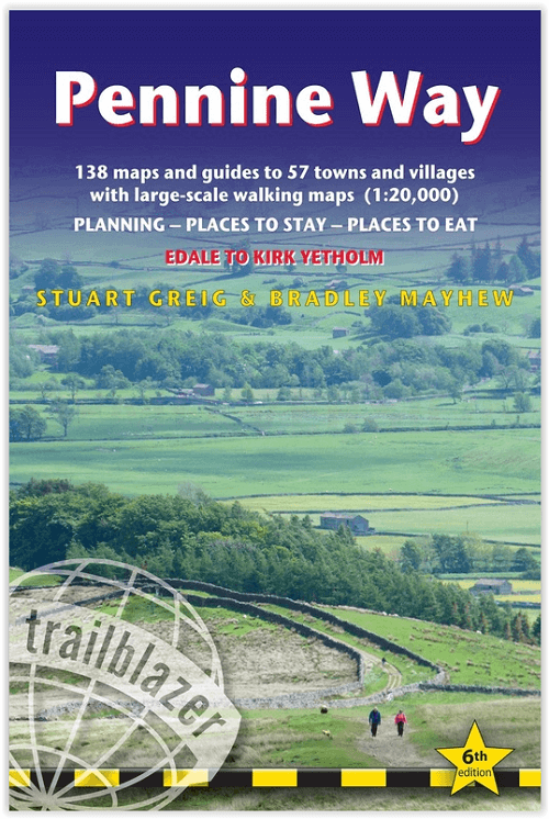
Wandelgids The Pennine Way - Trailblazer
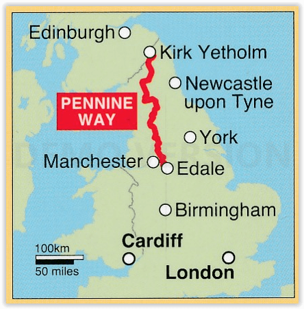
Edale (Peak District) tot Kirk Yetholm Scotisch borders - 420 km
Korte omschrijving
The Pennine Way 420 km - Trailblazer Productomschrijving: De Pennine Way, het bekendste nationale pad van Groot-Brittannië, slingert zich 420 km over woeste heidevelden en door stille dalen ...

Specificaties
- Uitgever: Trailblazer Publications
- ISBN-13: 9781912716333
- HOOFDCATEGORIEËN: Wandelgids
- Activiteiten: Wandelen, Hiking & Trekking
- Auteur: Bradley Mayhew, Stuart greig
- Regio: Cumbria & Lake District, England, Derbyshire & Peak District, England, Northumberland, Engeland, Yorkshire, England
- Land: England
- Lange afstand wandelroutes: Pennine Way (420 km)
- Blz.: 320
- Afmeting: 12x18
- Editie: 6
- Taal: Engels
Volledige omschrijving
The Pennine Way 420 km - Trailblazer
Productomschrijving: De Pennine Way, het bekendste nationale pad van Groot-Brittannië, slingert zich 420 km over woeste heidevelden en door stille dalen langs de ruggengraat van Noord-Engeland. Het begint in Edale in het Peak District en eindigt net over de grens in Schotland bij Kirk Yetholm. Dit prachtige wandelpad doorkruist 3 nationale parken - het Peak District, Yorkshire Dales en Northumberland - en toont het mooiste hooglandlandlandschap van Groot-Brittannië, terwijl het ook het literaire landschap van de familie Brontë en de Romeinse geschiedenis langs Hadrian's Wall raakt.
Engelse omschrijving: Pennine Way: Edale to Kirk Yetholm (British Walking Guide)
- 138 trail maps - 12 town plans - 15 stages maps with profiles and 2 overview maps- 60 colour photos - colour flower guide
The Pennine Way, Britain’s best-known National Trail, winds for 253 miles (420 km) over wild moorland and through quiet dales following the backbone of northern England. It begins in Edale in the Peak District and ends just over the border in Scotland at Kirk Yetholm. Crossing three national parks – the Peak District, Yorkshire Dales and Northumberland – this superb footpath showcases Britain’s finest upland scenery, while touching the literary landscape of the Brontë family and Roman history along Hadrian’s Wall.
- Post pandemic, stay-cations remain the holidays of choice
- Mapping now in new two-colour style
- All-in-one guide
Trailblazer guides include practical information not usually found in walking guides to the UK: reviews of places to stay, places to eat, attractions along the way and detailed public transport information showing all access points on the path and car parks near the trail, for weekend and day walkers. The largest scale walking maps available – At just under 1:20,000 (8cm or 31/8 inches to 1 mile) our maps (fully-edited and drawn by walkers for walkers) are bigger than even the most detailed walking maps currently available in the shops.

Artikelen uit dezelfde regio

Reisgids Lake District National park - Goldeneye • 9781859652046
Lake District National park - Goldeneye Productomschrijving: Dit boek is iets compleet anders. Het gaat hier om een onafhankelijke stem, omdat alle inhoud werd gekozen op basis van verdienste en verdienste alleen. In een digitaal tijdperk waar (reis)informatie wordt geleverd door reclamebudgetten. Hierbij een verfrissende en verhelderende kijk op wat het Lake District de bezoeker en bewone…

Wandelkaart OL27 North York Moors- Eastern area - OSI • 9780319469453
Wandelkaart North York Moors - Yorkshire England Omvat de: "Eastern area" Productbeschrijving: OS Explorer kaart OL27 omvat het North York Moors National Park, met inbegrip van de Cleveland Hills en The Hambleton Hills. Ook zijn op deze kaart de Celeveland way National Trail & de Tabular Hills way, Cleveland Street, Esk Valley Walk en het noordelijke uiteinde van Ebor way beschreven. D…

Wandelgids St Cuthbert's Way - Cicerone • 9781786311566
Wandelgids St Cuthbert's Way - Cicerone Productomschrijving: Deze wandelgids beschrijft de lange afstand St Cuthbert's Way door het ongerepte landschap van Northumberland en de Borders. De 100 km lange route begint in Melrose en doorkruist de ruige rotsen en heidevelden van de Cheviot Hills, gaat door het Northumberland National Park naar het sfeervolle Lindisfarne (Holy Island). De tocht …

Wandelgids Lakes- Meres and Waters of the Lake District • 9781786310873
Lakes- Meres and Waters of the Lake District - CIcerone Productomschrijving: Koning van de Fells. Iron man. Lake District bergloop legende. Joss Naylor is al deze dingen en meer. Zijn prestaties zijn verbluffend, zijn records blijven de tand des tijds doorstaan. In 1983 voltooide hij de Lakes, Meres and Waters (LMW) route van 105 mijl in maar liefst 19 uur en 14 minuten en tot op de dag va…

Reisgids Go Slow Yorkshire Dales NP - Bradt Travel guides • 9781784776091
Reisgids Yorkshire Dales - Bradt Productomschrijving: Deze nieuwe, grondig bijgewerkte editie van de Yorkshire Dales, onderdeel van Bradt's serie kenmerkende 'Slow guides' voor lokale Britse regio's, blijft de meest uitgebreide gids voor het gebied en beslaat het geheel van het onlangs uitgebreide Yorkshire Dales National Park, Nidderdale Area of Outstanding Natural Beauty AONB en enkele '…