
Wandelgids Walking the Munros Vol 1 - Cicerone Press
69 challenging routes across Glencoe- Bridge of Orchy and Mull

Korte omschrijving
Walking the Munros Vol 1 - Cicerone Productomschrijving: Wandelgids over de Munros in de zuidelijke, centrale en westelijke Highland's. De gids beschrijft 69 uitdagende routes over 139 van d...

Specificaties
- Uitgever: CICERONE Press
- ISBN-13: 9781786311054
- HOOFDCATEGORIEËN: Wandelgids
- Activiteiten: Wandelen, Hiking & Trekking
- Auteur: Steve Kew
- Regio: Highlands, Schotland
- Land: Schotland
- Blz.: 272
- Afmeting: 12x17
- Editie: 4
- Taal: Engels
Volledige omschrijving
Walking the Munros Vol 1 - Cicerone
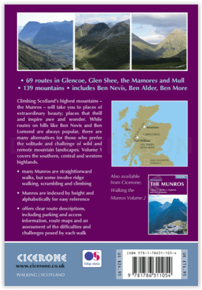
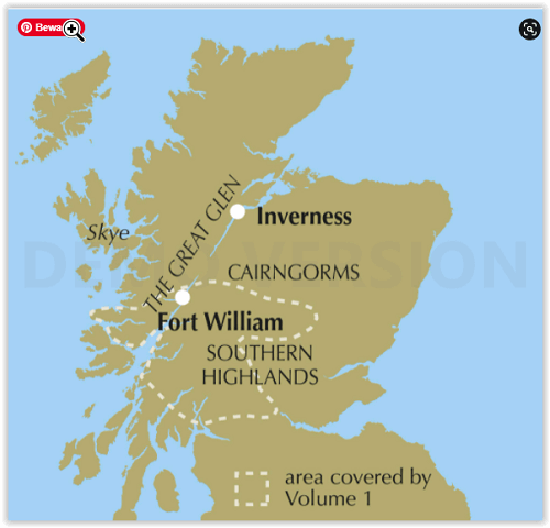
Productomschrijving: Wandelgids over de Munros in de zuidelijke, centrale en westelijke Highland's. De gids beschrijft 69 uitdagende routes over 139 van de meest iconische 3000f+ bergen in gebieden zoals Glencoe, Bridge of Orchy en Mull. Inclusief routes op Ben More, Ben Alder, Ben Lomond en Ben Nevis, de hoogste berg van de Britse eilanden. Deel 1 van twee reisgidsen.
Engelse omschrijving: Guidebook to walking the Munros in southern, central and western Highlands. Describes 69 challenging routes across 139 of the iconic 3000ft+ mountains covering areas such as Glencoe, Bridge of Orchy and Mull. Includes routes up Ben More, Ben Alder, Ben Lomond and Ben Nevis, the highest mountain in the British Isles. Volume 1 of two guidebooks.
Seasons:
Year-round mountain walking, with summer walking in mind. However, midges may hold you back in summer, and if snow's not your thing then avoid winter.
Centres:
Fort William, Glencoe, Killin, Pitlochry, Blair Atholl, Oban and many more.
Difficulty:
Many Munros are straightforward walks, but some have exciting ridge walking and scrambling. Aonach Eagach is covered in this volume. Normal Scottish mountain challenges and precautions.
Must See:
The extroardinary beauty of Scotland's mountain landscape; the challenge of a long and strenuous climb; the achievement of the summit; the sight of wilderness stretching out for miles around; the tidal wave of cloud flowing over a ridge; the sweet peace of that first refreshment at the end of the day.
Locatie op kaart
Artikelen uit dezelfde regio

Wandelkaart 416 Inverness Loch Ness & Culloden - OSI • 9780319472712
Wandelkaart Inverness- Loch Ness & Culloden Highland's Omvat ook: Fort Augustus & Drumnadrochit. Productbeschrijving: Deze twee-zijdige Explorer kaart nummer 416 heeft betrekking op de lengte van Loch Ness en de Highland hoofdstad van Inverness. Wandel de Great Glen way op de oevers van loch Ness, om te zien of u ter plaatse het legendarische monster kunt ontdekken, of ga op verkennin…

Wandelkaart 34 Fort Augustus- Loch Ness Highland's - OSI • 9780319473573
Wandelkaart Fort Augustus - Loch Ness Highland's Schotland Omvat ook: Glen Albyn & Glen Roy Productomschrijving: Gelegen aan de zuidelijke oevers van de wereld beroemde Loch Ness, is Fort Augustus het charmante dorp omgeven door iconische Schotse landschap. OS Landranger kaart 34 toont de Great Glen way die de regio passeert waardoor het een aantrekkelijke uitvalsbasis is voor wandelaa…

Wandelkaart 390 Ardnamurchan- Highlands Schotland - OSI • 9780319246337
Wandelkaart Ardnamurchan - Highlands Schotland Productbeschrijving: Moidart, Sunart & Loch Shiel 390 - Ardnamurchan, Hoghlands Schotland - Deze twee-zijdige kaart toont het schiereiland Ardnamurchan en het eiland van Muck. Grotendeels ongerept, en met een lage menselijke populatie, dit gebied is een toevluchtsoord voor wilde dieren van alle soorten. De OS Explorer kaart voor Ardnamurc…

Wandelkaart XT40 Ben Nevis Grampian - Harvey Ultramaps • 9781851375776
Wandelkaart XT40 - Ben Nevis Grampian - Harvey Ultramaps Productomschrijving: Ben Nevis is de hoogste berg van Schotland en ligt in het Grampian Gebergte in het graafschap Inverness aan de ingang van de Glenmore. Het is eveneens de hoogste berg van het volledige Verenigd Koninkrijk. Ben Nevis is 1345 meter hoog en bevindt zich nabij Fort William, ongeveer 160 km ten noorden van Glasgow. He…

Wandelgids The John Muir Way - Rucksack Readers • 9781913817145
The John Muir Way - Rucksack Readers Productomschrijving: De John Muir Way loopt over een afstand van 215 km, van kust tot kust door centraal Schotland, van Helensburgh aan de Clyde naar Dunbar aan de Noordzee. De route is net zo geschikt voor fietsers als voor wandelaars en kan van kust tot kust worden afgelegd of in delen - tien voor wandelaars of vijf voor fietsers. De aantrekkingsk…