
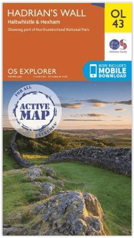
Wandelkaart OL43 Hadrian's Wall - OSI
inclusief Haltwhistle & Hexham area

Korte omschrijving
Wandelkaart Hadrian's Wall - England Productomschrijving: Wandel in de shaduw van de romeinen en ontdek dit eeuwen oud monument van om en bij de 2000 jaar oud. Hoogtepunten omvatten: Gilslan...

Specificaties
- Uitgever: Ordnance Survey
- ISBN-13: 9780319475621
- HOOFDCATEGORIEËN: Wandelkaart
- Activiteiten: Wandelen, Hiking & Trekking
- Regio: Northumberland, Engeland
- Land: England
- Waterafstotende kaart: Ordnance Survey ACTIVE Explorer Weatherproof Maps
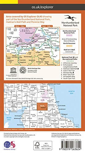
- Historische wandelroutes: Hadrian's Wall path (135 km)
- Nationale parken: Northumberland NP, England
- UNESCO werelderfgoed: Hadrian's Wall Path (135 km)
- Schaal: 1:25000
- Afmeting: 13x24
- Taal: Engels
- Reeks: Explorer ACTIVE
Volledige omschrijving
Wandelkaart Hadrian's Wall - England
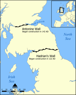
Productomschrijving: Wandel in de shaduw van de romeinen en ontdek dit eeuwen oud monument van om en bij de 2000 jaar oud. Hoogtepunten omvatten: Gilsland, Corbridge, Haltwhistle, Humshaugh, Hexham, Haydon Bridge, Bardon Mill, Greenlea lough, Housesteads, Chesters Roman Fort & Vindolanda. Een van de klassieke wandelingen van Engeland, en één die genotteerd is op de lijst van het UNESCO werelderfgoed. Bijzondere interessante hike met grote cultureel gehalte. Ontdek wat de romeinen in die tijd allemaal bewerkstelligden om de schoten buiten te houden.
Engelse omschrijving: Walk in the footsteps of the Romans and experience this ancient frontier with over 2,000 years of history. Highlights include: Gilsland, Corbridge, Haltwhistle, Humshaugh, Hexham, Haydon Bridge, Bardon Mill, Greenlea lough, Housesteads, Chesters Roman Fort, and Vindolanda.
Locatie op kaart
Overzichtskaarten

Hystorische wandel- en fietsroutes
Hystorische wandel- en fietsroutes

Producten op de overzichtskaart
Klik op een product om naar de detailpagina te gaan.
- Wandelkaart - South Downs Way - Harvey maps
- Wandelgids - North Yorkshire historic walks - Cicerone
- Wandelkaart OL13 - Brecon Beacons NP - Eastern area - OSI
- Wandelgids - Pilgrim Pathways walking guide - Trailblazer
- Wandelgids - The Great Glen Way - Trailblazer
- Wandelgids - Hadrian's wall Path - Knife Edge
- Wandelgids - Hadrian's Wall Path - Trailblazer
- Wandelkaart XT40 - Offa's Dyke Path - Harvey Maps
- Wandelkaart OL43 - Hadrian's Wall - OSI
- Wandelgids - Cleveland Way - Trailblazer
- Wandelkaart 351 - Dunbar & North Berwick- Schotland - OSI
- Wandelgids - Walking in the Forest of Dean - Cicerone
- Wandelkaart 130 - Salisburry & Stonehenge- Wiltshire - OSI
- Wandelkaart 256 - Wrexham- Wrecsam & Llangollen - OSI
- Wandelkaart 130 - Salisbury & Stonehenge- Wiltshire - OSI
- Wandelgids - John Muir Trail - Cicerone
- Wandelkaart - Rob Roy Way National trail - Harvey maps
- Wandelkaart - Hadrian's Wall Path - Harvey maps
- Wandelkaart - Offa's Dyke Path- Route Map Booklet - Cicerone

OSI Explorer & Explorer Active - Noord Engeland - Lake District
OSI Explorer & Explorer Active - Noord Engeland - Lake District

Producten op de overzichtskaart
Klik op een product om naar de detailpagina te gaan.
- Wandelkaart 275 Liverpool- South West England - OSI
- Wandelkaart 276 Bolton- Wigan & Warrington- Machester - OSI
- Wandelkaart 277 Manchester & Salford - OSI
- Wandelkaart 278 Sheffield & Barnsley- South Yorkshire - OSI
- Wandelkaart 279 Doncaster- South Yorkshire - OSI
- Wandelkaart 280 Isle of Axholme- Lincolnshire - OSI
- Wandelkaart 281 Ancholme Valley- Lincolnshire - OSI
- Wandelkaart 283 Louth & Mablethorpe- Lincolnshire - OSI
- Wandelkaart 284 Grimsby- Cleethorpes & Immingham - OSI
- Wandelkaart 285 Southport & Chorley- Merseyside - OSI
- Wandelkaart 286 Blackpool & Preston- Lancashire - OSI
- Wandelkaart 287 West Pennine Moors- Lankashire - OSI
- Wandelkaart 288 Bradford & Huddersfield- West Yorkshire - OSI
- Wandelkaart 289 Leeds- Harrogate- Wetherby & Pontefract - OSI
- Wandelkaart 290 York- Selby & Tadcaster- North Yorkshire - OSI
- Wandelkaart 291 Goole & Gilberdyke- Yorkshire - OSI
- Wandelkaart 292 Withernsea & Spurn Head- East Riding - OSI
- Wandelkaart 293 Kingston upon Hull & Beverley - OSI
- Wandelkaart 294 Market Weighton & central Yorkshire Wolds - OSI
- Wandelkaart 295 Bridlington- Driffield & Hornsea - OSI
- Wandelkaart 296 Lancaster- Morecambe & Fleetwood - OSI
- Wandelkaart 297 Lower Wharfedale & Washburn Valley - OSI
- Wandelkaart 298 Nidderdale AONB- Yorkshire - OSI
- Wandelkaart 299 Ripon & Boroughbridge- North Yorkshire - OSI
- Wandelkaart 300 Howardian Hills AONB & Malton - OSI
- Wandelkaart 301 Scarborough- Bridlington & Flamborough
- Wandelkaart 302 Northallerton & Thirsk- North Yorkshire
- Wandelkaart 303 Whitehaven & Workington - OSI
- Wandelkaart 304 Darlington & Richmond- North Cleveland
- Wandelkaart 305 Bishop Auckland & Durham - OSI
- Wandelkaart 306 Middlesbrough & Hartlepool - OSI
- Wandelkaart 307 Consett & Derwent reservoir - OSI
- Wandelkaart 308 Durham & Sunderland- England - OSI
- Wandelkaart 314 Solway Firth- Wigton & Silloth - OSI
- Wandelkaart 315 Carlisle- Brampton- Longtown - OSI
- Wandelkaart 316 Newcastle upon Tyne- Northumberland- OSI
- Wandelkaart OL2 Yorkshire Dales- Southern & Western Areas - OSI
- Wandelkaart OL19 Howgill Fells and Upper Eden Valley - OSI
- Wandelkaart OL21 South Pennines - Yorkshire - OSI
- Wandelkaart OL26 North York Moors - Western area - OSI
- Wandelkaart OL27 North York Moors- Eastern area - OSI
- Wandelkaart OL30 Yorkshire Dales - Yorkshire England - OSI
- Wandelkaart OL31 North Pennines- Teesdale & Weardale - OSI
- Wandelkaart OL41 Forest of Bowland & Ribblesdale - OSI
- Wandelkaart OL43 Hadrian's Wall - OSI

OSI Explorer & Explorer Active - Zuid Scotisch Borders
OSI Explorer & Explorer Active - Zuid Scotisch Borders

Producten op de overzichtskaart
Klik op een product om naar de detailpagina te gaan.
- Wandelkaart 307 Consett & Derwent reservoir - OSI
- Wandelkaart 308 Durham & Sunderland - England - OSI
- Wandelkaart 309 Stranraer & The Rhins - Dumfries - OSI
- Wandelkaart 310 Glenluce & Kirkcowan - Schotland - OSI
- Wandelkaart 311 Wigtown- Whithorn & The Machars - OSI
- Wandelkaart 312 Kirkcudbright & Castle Douglas - OSI
- Wandelkaart 313 Dumfries & Dalbeattie- Schotland - OSI
- Wandelkaart 314 Solway Firth- Wigton & Silloth - OSI
- Wandelkaart 315 Carlisle- Brampton & Longtown - OSI
- Wandelkaart 316 Newcastle upon Tyne - Northumberland - OSI
- Wandelkaart 137 Ballantrae South Ayrshire- Schotland- OSI
- Wandelkaart 318 Galloway Forest Park North- Ayrshire
- Wandelkaart 319 Galloway Forest Park South - OSI
- Wandelkaart 320 Castle Douglas & Loch Ken - OSI
- Wandelkaart 321 Nithsdale & Dumfries & Thornhill - OSI
- Wandelkaart 322 Annandale- Dumfries & Galoway - OSI
- Wandelkaart 323 Eskdale & Castle O'er Forest- Schotland - OSI
- Wandelkaart 324 Liddesdale & Kershope Forest - OSI
- Wandelkaart 325 Morpeth & Blyth - Northumberland - OSI
- Wandelkaart 326 Ayr & Troon - South Ayrshire - OSI
- Wandelkaart 327 Cumnock & Dalmellington - OSI
- Wandelkaart 328 Sanquhar & New Cumnock - OSI
- Wandelkaart 329 Lowther Hills- Sanquhar & Leadhills - OSI
- Wandelkaart 330 Moffat & St Mary's Loch - Dumfries - OSI
- Wandelkaart 331 Teviotdale South - Schotisch Borders - OSI
- Wandelkaart 332 Alnwick Amble - Northumberland - OSI
- Wandelkaart 333 Kilmarnock & Irvine - East Ayrshire - OSI
- Wandelkaart 334 East Kilbride- Galston & Darvel - Glasgow - OSI
- Wandelkaart 335 Lanark & Tinto Hills - South Lankashire - OSI
- Wandelkaart 336 Biggar & Broughton - South Lanarkshire - OSI
- Wandelkaart 337 Peebles & Interleithen - Schotish Borders - OSI
- Wandelkaart 338 Galashiels- Selkirk & Melrose - OSI
- Wandelkaart 339 Kelso- Coldstream & Lower Tweed Valley - OSI
- Wandelkaart 340 Holy Island & Bamburgh - OSO
- Wandelkaart 341 Greenock- Largs & Millport - OSI
- Wandelkaart 342 Glasgow Schotland - OSI
- Wandelkaart 343 Motherwell & Coatbridge- Glasgow - OSI
- Wandelkaart 344 Pentland Hills RP- Edinburgh - OSI
- Wandelkaart 345 Lammermuir Hills - Edinburgh - OSI
- Wandelkaart 346 Berwick-upon-Tweed - Northumberland - OSI
- Wandelkaart 349 Falkirk- Cumbernauld & Livingston - OSI
- Wandelkaart 350 Edinburgh - East Schotland - OSI
- Wandelkaart 351 Dunbar & North Berwick - Edinburgh - OSI
- Wandelkaart 361 Isle of Arran - OSI
- Wandelkaart 362 Cowal West & Isle of Bute - OSI
- Wandelkaart OL16 Cheviot Hills Northumberland - OSI
- Wandelkaart OL42 Kielder Water & Forest - OSI
- Wandelkaart OL43 Hadrian's Wall - OSI
- Wandelkaart OL37 Cowal East- Dunoon & Iverary - OSI
- Wandelkaart OL38 Loch Lomond South & Dumbarton - OSI
Artikelen uit dezelfde regio

Wandelkaart 340 Holy Island & Bamburgh - OSO • 9780319263907
Wandelkaart Holy Island & Bamburgh - OSI Productomschrijving: Holy Island en Bamburgh zijn 2 aan de kust liggende eilanden/archipel die de interesse trekt van velen in het teken van natuur bezoek, wandelen of fietsen. De locatie is zeer mooi wat de natuur betreft. Omvat: Cheswick, Ancroft, Haggerston, Bowsden, Beal, Fenwick; Holy Island, Holburn, Doddington, Belford, Waren Mill, Bambur…

Wandelgids Forth to Farne Way - Schotland - Rucksack Readers • 9781898481966
Wandelgids Forth to Farne Way - Schotland Productomschrijving: Deze inspirerende pelgrimsroute van 110 mijl begint vanuit North Berwick aan de Firth of Forth bij Edinburgh en gaat verder via de 12e-eeuwse kerk van Whitekirk naar Dunbar. Het volgt de Noordzeekust naar het adembenemende landschap van St-Abb's Head en bezoekt Coldingham Priory, misschien wel het belangrijkste benedictijnenklo…

Wandelkaart XT25 Cheviot Hills - Harvey Maps • 9781851376094
Wandelkaart Cheviot Hills - Harvey Maps Productomschrijving: Ideaal voor The Cheviot, Windy Gyle en het noordelijke deel van Northumberland National Park. Omvat: Wooler, Kirk Yetholm, Breamish Valley en Harthope Valley - Lichtgewicht, gedetailleerd, duidelijk en makkelijk te lezen - Geprint op sterk, 100% watervast en scheurbestendig papier - Toont de horeca voor na je dagtrip …

Wandelgids St Oswald's Way & Northumberland Coast Path - Cicerone • 9781786311559
St Oswald's Way & Northumberland Coast Path - Cicerone Productomschrijving: Deze gids beschrijft de St Oswald's Way en Northumberland Coast Paths, beide langeafstandswandelpaden door Northumberland. St Oswald's Way (156 km, 97 mijl) begint in Heavenfield en doorkruist delen van het Northumberland National Park en bezoekt Hadrian's Wall, de Simonside Hills en de prachtige Coquet Valley, voo…

Wandelkaart 340 Active - Holy Island & Bamburgh - OSI • 9780319475768
Wandelkaart Holy Island & Bamburgh - Explorer Active Productomschrijving: Holy Island en Bamburgh zijn 2 aan de kust liggende eilanden/archipel die de interesse trekt van velen in het teken van natuur bezoek, wandelen of fietsen. De locatie is zeer mooi wat de natuur betreft. Omvat: Cheswick, Ancroft, Haggerston, Bowsden, Beal, Fenwick, Holy Island, Holburn, Doddington, Belford, Waren …