
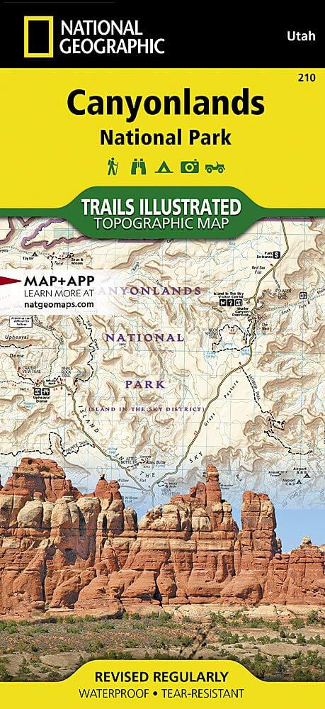
Wandelkaart 210 Canyonlands NP - Utah - Natgeo
Gelegen in het Zuidoosten van Utah- dichtbij de stad Moab
Korte omschrijving
TOPO Wandelkaart 210 - Canyonlands NP - Utah - Nat geo Productomschrijving: Canyonlands National Park is een Amerikaans nationaal park gelegen in het Zuidoosten van Utah, dichtbij de stad M...

Specificaties
- Uitgever: National Geographic
- ISBN-13: 9781566953269
- HOOFDCATEGORIEËN: Wandelkaart
- Activiteiten: Wandelen, Hiking & Trekking
- Regio: Utah, USA
- Land: Verenigde Staten van Amerika (USA)
- Nationale parken: Canyonlands NP, Utah USA
- Schaal: 1:70000
- Afmeting: 10x19
- Taal: Engels
Volledige omschrijving
TOPO Wandelkaart 210 - Canyonlands NP - Utah - Nat geo
Productomschrijving: Canyonlands National Park is een Amerikaans nationaal park gelegen in het Zuidoosten van Utah, dichtbij de stad Moab. Het park omvat een kleurrijk landschap, geerodeerd in verschillende canyons door het water van de Colorado River. The park is verdeeld in 4 districten: the Island in the Sky District, the Needles district, the Maze district, en the combined rivers—the Green & Colorado rivieren
Engelse omschrijving: National Geographic's Trails Illustrated map of Canyonlands National Park is designed to meet the needs of outdoor enthusiasts by combining valuable information with unmatched detail of this mesmerizing landscape of river canyons and fantastically formed buttes. Expertly researched and created in partnership with local land management agencies, this map is loaded with helpful information on the park's archaeology, Glen Canyon, Horseshoe Canyon, backcountry safety, park regulations and more. Key areas of interest featured on this map include Canyon Rims Recreation Area; Glen Canyon National Recreation Area; the Island in the Sky district; the Needles district; and the Maze district.
With miles of clearly marked trails that include mileages between intersections, this map will prove invaluable in your exploration of the park. River mileage on the Colorado and Green rivers is noted as well, for those exploring the winding river canyons by boat. Some of the many recreation features include visitor centers, campgrounds, points of interest, scenic overlooks, and boat launch sites. The map base includes contour lines and elevations for summits and passes. Every Trails Illustrated map is printed on "Backcountry Tough" waterproof, tear-resistant paper. A full UTM grid is printed on the map to aid with GPS navigation.
Other features found on this map include: Canyonlands National Park, Glen Canyon National Recreation Area, Green River, Orange Cliffs, Soda Springs Basin.
Locatie op kaart
Gekoppelde artikelen

Wandelkaart 310 Canyonlands NP - Island in the Sky District • 9781566954600
standaard versieTOPO Wandelkaart 310 -Canyonlands NP - Island in the Sky District Productomschrijving: Canyonlands National Park is een Amerikaans nationaal park gelegen in het Zuidoosten van Utah, dichtbij de stad Moab. Het park omvat een kleurrijk landschap, geerodeerd in verschillende canyons door het water van de Colorado River. Het park is verdeeld in 4 districten: the Island in the Sky District, the…

Wandelkaart 311 Canyonlands NP - Needles District - Natgeo • 9781566954617
standaard versieTOPO Wandelkaart 311 - Canyonlands NP - Needles District Productomschrijving: Canyonlands National Park is een Amerikaans nationaal park gelegen in het Zuidoosten van Utah, dichtbij de stad Moab. Het park omvat een kleurrijk landschap, geerodeerd in verschillende canyons door het water van de Colorado River. Het park is verdeeld in 4 districten: the Island in the Sky District, the Needles …
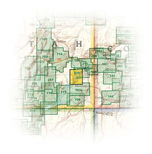
Overzichtskaarten

NAT GEO Utah trail maps
NAT GEO Utah trail maps

Producten op de overzichtskaart
Klik op een product om naar de detailpagina te gaan.
- Wandelkaart 210 Canyonlands NP - Utah - Natgeo
- Wandelkaart 211 Arches National Park- Utah - Natgeo
- Wandelkaart 214 Zion National Park - Natgeo
- Wandelkaart 219 Bryce Canyon NP Utah - Natgeo
- Wandelkaart 220 Dinosaur National Monument - Natgeo
- Wandelkaart 267 Capitol Reef NP Utah - Natgeo
- Wandelkaart 310 Canyonlands NP - Island in the Sky District
- Wandelkaart 311 Canyonlands NP - Needles District - Natgeo
- Wandelkaart 312 Canyonlands NP - Maze District - Natgeo
- Wandelkaart 702 Cedar Mountain - Utah USA - Nat Geo
- Wandelkaart 703 Manti-La Sal National forest - Natgeo
- Wandelkaart 704 Flaming Gorge- Recreational Area - Utah
- Wandelkaart 705 Mount Dutton & Aquarius Plateau - Nat Geo
- Wandelkaart 213 Glen Canyon & Capitol Reef NP - Nat Geo
NAT GEO Utah trail maps
NAT GEO Utah trail maps
Producten op de overzichtskaart
Klik op een product om naar de detailpagina te gaan.
- Wandelkaart 210 Canyonlands NP - Utah - Natgeo
- Wandelkaart 211 Arches National Park- Utah - Natgeo
- Wandelkaart 214 Zion National Park - Natgeo
- Wandelkaart 219 Bryce Canyon NP Utah - Natgeo
- Wandelkaart 220 Dinosaur National Monument - Natgeo
- Wandelkaart 267 Capitol Reef NP Utah - Natgeo
- Wandelkaart 310 Canyonlands NP - Island in the Sky District
- Wandelkaart 311 Canyonlands NP - Needles District - Natgeo
- Wandelkaart 312 Canyonlands NP - Maze District - Natgeo
- Wandelkaart 703 Manti-La Sal National forest - Natgeo
- Wandelkaart 704 Flaming Gorge- Recreational Area - Utah
- Wandelkaart 709 Wasatch Front North Utah - Nat Geo
- Wandelkaart 710 Canyons of the Escalante NP - Nat Geo
- Wandelkaart 213 Glen Canyon & Capitol Reef NP - Nat Geo
Artikelen uit dezelfde regio

Wandelkaart 705 Mount Dutton & Aquarius Plateau - Nat Geo • 9781566954150
Wandelkaart Mount Dutton & Aquarius Plateau - Nat Geo Omvat: Black Butte, Bryce Canyon National Park, Dixie National Forest, Paunsaugunt Plateau, Pink Cliffs, Sevier Plateau. Engelse omschrijving: This map covers the spectacularly scenic stretch in southern Utah of the Powell and Escalante Ranger Districts of Dixie National Forest—from Bicknell Bottom State Wildlife Area in the Northw…

Wandelkaart 707 Fish Lake - Manti- Utah Natgeo • 9781566953306
TOPO Wandelkaart 707 - Fish Lake - Manti- Utah - Nat Geo Productomschrijving: Fish Lake is een soort Alpine meer gelegen op 2,700 m in Fishlake op de zuidelijke Wasatch Plateau regio van zuid-centraal Utah, United States. Het ligt binnen het Fishlake National Forest. Fish Lake is 7.9 km lang en 1.3 km breedt, en ligt in een geologische structuur gekend als "graben valley". Engelse oms…

Wandelkaart 505 Moab Greater Region - Utah USA - Nat Geo • 9781566959001
Wandelkaart Moab Utah USA - Nat Geo Productomschrijving: Moab is een zeer goed gekende locatie in het Amerikaanse Utah, tevens de hoofdplaats van Grand County. Op toeristisch vlak is Moab gekend voor zijn excursies naar de nabijgelegen natuurgebieden Arches en Canyonlands. Daarnaast is Moab de uitvalsbasis voor rafting op de Colorado river en tochten met de mountainbike, waarbij de Slickro…

Reisgids Utah's national parks - Lonely planet • 9781838699857
Utah's national parks - Lonely planet Productomschrijving: Lonely Planet Zion & Bryce National Parks is jou paspoort voor het meest relevante, actuele advies over wat je moet zien en overslaan, en welke verborgen ontdekkingen er op je wachten. Wandel de Cable Mountain trail in Zion, rijd op een paard of muilezel door Bryce of ga zwemmen of tuben in Zion's Virgin River, allemaal met je vert…

Wandelkaart 700 Ogden- Monte Cristo Range Utah USA - Nat Geo • 9781566956345
Ogden- Monte Cristo Range- Utah USA - Nat Geo Productomschrijving: Outdoor enthousiastelingen die willen genieten van de grenzeloze recreatieve mogelijkheden in het noorden van Utah net ten oosten van Great Salt Lake zullen zich vergapen aan National Geographic's Trails Illustrated kaart van Ogden en de Monte Cristo Range. Ontworpen met een breed scala van bezoekers in het achterhoofd, wer…