
Wandelkaart 221 Death Valley NP - Nevada - Natgeo
Gelegen ten oosten van de Sierra Nevada
Korte omschrijving
TOPO Wandelkaart 221 - Death Valley NP - Nevada - Nat Geo Productomschrijving: Death Valley National Park is een Amerikaans nationaal park die de California—Nevada grens aanraakt, ten ooste...

Specificaties
- Uitgever: National Geographic
- ISBN-13: 9781566953214
- HOOFDCATEGORIEËN: Wandelkaart
- Regio: Californië, USA
- Land: Verenigde Staten van Amerika (USA)
- Nationale parken: Death Valley NP, California, Nevada USA
- Schaal: 1:165000
- Afmeting: 10x19
- Taal: Engels
Volledige omschrijving
TOPO Wandelkaart 221 - Death Valley NP - Nevada - Nat Geo
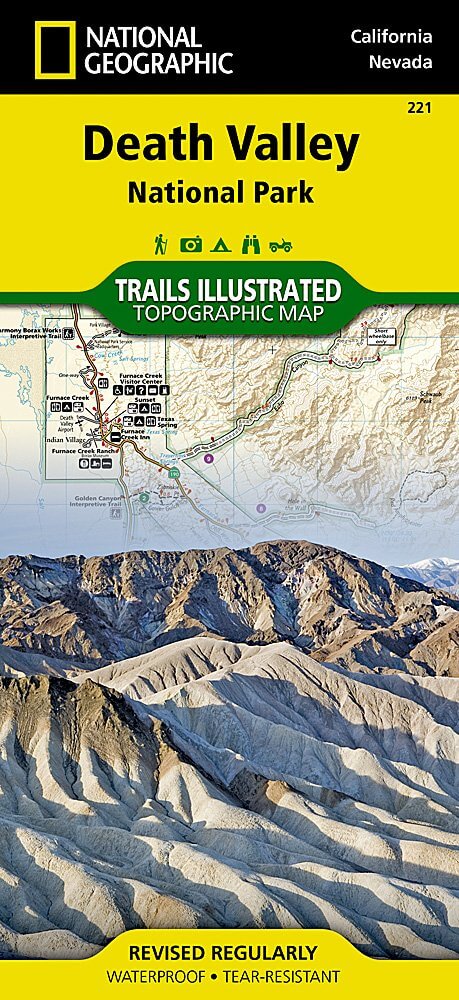
Productomschrijving: Death Valley National Park is een Amerikaans nationaal park die de California—Nevada grens aanraakt, ten oosten van de Sierra Nevada. De grenzen omvatten Death Valley, het noordelijk deel van Panamint Valley, het zuidelijk deel van Eureka Valley, en het de meerderheid van Saline Valley.
Engelse omschrijving: Despite its foreboding name and the fact that it is the hottest, lowest, and driest area in North America, Death Valley National Park maintains a great diversity of life in its dramatic terrain of salt-flats, canyons, mountains, valleys, sand dunes, and badlands. National Geographic's Trails Illustrated map of Death Valley National Park delivers unmatched detail and valuable information to assist you in your visit to this land of extremes. Expertly researched and created in partnership with local land management agencies, this map features key areas of interest including Badwater Basin, Furnace Creek, Scotty's Castle, Panamint Springs, and Stovepipe Wells.
With miles of clearly marked trails that include mileages between intersections, this map will prove invaluable in your exploration of the park. A list of backcountry roads and trails complete with descriptions, lengths, and starting points will help you choose a route that's right for your activity level and recreation use. The map base includes contour lines and elevations for summits. Hot weather tips, a temperature chart, regulations, and safety suggestions are included as well. Every Trails Illustrated map is printed on "Backcountry Tough" waterproof, tear-resistant paper. A full UTM grid is printed on the map to aid with GPS navigation.
Other features found on this map include: Amargosa Desert, Amargosa River, Badwater Basin, Bare Mountain, Black Mountains, Cottonwood Mountains, Death Valley, Eureka Valley, Funeral Mountains, Gold Mountain, Grapevine Mountains, Greenwater Range, Inyo Mountains, Inyo Mountains Wilderness, Inyo National Forest, Last Chance Mountain, Nelson Range, New York Butte, Owens Lake, Owens River, Owlshead Mountains, Panamint Range, Saline Valley, Sarcobatus Flat, Searles Lake, Telescope Peak, Towne Pass, Tucki Mountain, Ubehebe Peak.
.jpg)
Locatie op kaart
Overzichtskaarten

NAT GEO California trail maps
NAT GEO California trail maps

Producten op de overzichtskaart
Klik op een product om naar de detailpagina te gaan.
- Wandelkaart 205 Sequoia & Kings Canyon NP - California
- Wandelkaart 206 Yosemite NP - California - Nat Geo
- Wandelkaart 218 Redwood National & State Parks - Nat Geo
- Wandelkaart 221 Death Valley NP - Nevada - Natgeo
- Wandelkaart 226 Joshua Tree NP - California - Nat Geo
- Wandelkaart 256 Mojave National park California - Nat Geo
- Wandelkaart 306 Yosemite SW- Yosemite Valley - Nat Geo
- Wandelkaart 307 Yosemite NP North West - Nat Geo
- Wandelkaart 308 Yosemite NE- Tuolumne Meadows - Nat Geo
- Wandelkaart 309 Yosemite SE - Ansel Adams Wilderness - Nat Geo
- Wandelkaart 322 Mount Whitney California - Nat Geo
- Wandelkaart 803 Lake Tahoe Basin - California - Nat Geo
- Wandelkaart 804 Tahoe National Forest West - Nat Geo
- Wandelkaart 805 Tahoe Nat. Forest East - Sierra Buttes - Nat Geo
- Wandelkaart 809 Mammoth Lakes - Mono Divide - Nat Geo
- Wandelkaart 810 Shaver Lake - Sierra National Forest - Nat Geo
Artikelen uit dezelfde regio

Wandelkaart 308 Yosemite NE- Tuolumne Meadows - Nat Geo • 9781566953696
Yosemite North East - Tuolumne Meadows - Nat Geo Productomschrijving: National Geographic's Trails Illustrated kaart van Yosemite NE: Tuolumne Meadows and Hoover Wilderness is ontworpen om te voldoen aan de behoeften van outdoor enthousiastelingen door het combineren van waardevolle informatie met ongeëvenaarde details van deze prachtige regio van het park. Deskundig onderzocht en gemaakt …

Reisgids San Francisco pocket guide - Lonely Planet • 9781787014114
San Francisco pocket guide - Lonely Planet Coverage Includes: Golden Gate Bridge, The Marina, Fisherman’s Wharf, North Beach, Chinatown, Downtown, SoMa, Hayes Valley, Civic Center, The Mission, The Haight, Golden Gate Park, and more Product description: Lonely Planet Pocket San Francisco is your passport to the most relevant, up-to-date advice on what to see and skip, and what hidden d…

Wandelgids Hiking the Pacific Crest Trail - Cicerone • 9781852849207
Hiking the Pacific Crest Trail - PCT - Cicerone Productomschrijving: Een wandelgids over de Pacific Crest Trail (PCT), een epische wandeling van 3300 km van de Mexicaanse grens naar het Canadese British Columbia. Een van 's werelds beste wandelingen, de route loopt door Californië, Oregon en de staat Washington, langs de Mojave-woestijn, High Sierras, Cascades en talloze meer wilde bergen …

Wandelkaart 814 Big Sur & Ventana Wilderness - Natgeo • 9781566955782
TOPO Wandelkaart 814 - Big Sur & Ventana Wilderness - Natgeo Productomschrijving: Big Sur & Ventana Wilderness California- Natgeo zijn in andere woorden, het Los Padres National Forest in het United States national forest in southern en central California. National Geographic's Trails Illustrated map of Big Sur, Ventana Wilderness combines unmatched detail with helpful information to o…

Wandelgids Toptrails - Nordamerika West - Rother • 9783763331857
Toptrails - Nordamerika West - Rother Productomschrijving: De uitgestrekte gebieden van het Amerikaanse Westen herbergen een grote verscheidenheid aan buitengewone natuurlandschappen. De bekendste werden al vroeg beschermd als de eerste nationale parken op aarde. Uitstekend ontwikkelde bezoekersfaciliteiten maken de spectaculaire bergen, kusten en woestijnen gemakkelijk toegankelijk voor i…