
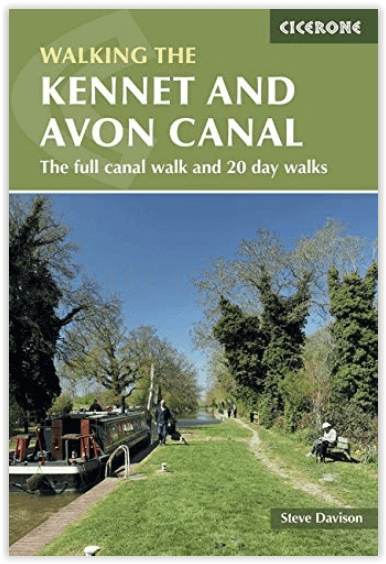
Wandelgids The Kennet and Avon Canal walking guide - Cicerone
From Reading to Bristol - 7 stages - 151 km
Korte omschrijving
The Kennet and Avon Canal walking guide - Cicerone Productomschrijving: Gids voor wandelen langs het Kennet & Avon Kanaal. De 94 mijl lange route van Reading naar Bristol is opgedeeld in 7 r...

Specificaties
- Uitgever: CICERONE Press
- ISBN-13: 9781852847869
- HOOFDCATEGORIEËN: Wandelgids
- Activiteiten: Wandelen, Hiking & Trekking
- Auteur: Steve Davison
- Regio: South & South East England
- Land: United Kingdom, Great Britain
- UNESCO werelderfgoed: Bath, England, Bristol's Floating Harbour, England
- AONB - Area of Outstanding Beauty: Cotswolds AONB, North Wessex Downs AONB
- Blz.: 240
- Afmeting: 12x17
- Editie: 1
- Taal: Engels
Volledige omschrijving
The Kennet and Avon Canal walking guide - Cicerone
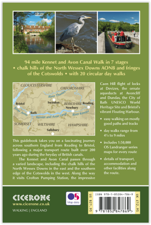
Productomschrijving: Gids voor wandelen langs het Kennet & Avon Kanaal. De 94 mijl lange route van Reading naar Bristol is opgedeeld in 7 redelijk gemakkelijke etappes en omvat het UNESCO werelderfgoed Bath en de drijvende haven van Bristol. Er zijn ook 20 rondwandelingen opgenomen, variërend van 4¼ tot 9 mijl, waarbij de beste delen van het kanaal worden aangedaan.
Omvat: Reading, Newbury, Hungerford, Great Bedwyn, Pewsey, Devizes, Bradford-on-Avon, Bath, Keynsham and Bristol.
Engelse omschrijving: Guidebook to walking along the Kennet & Avon Canal. The 94 mile route from Reading to Bristol is split into 7 stages of fairly easy walking and includes the UNESCO World Heritage Site of Bath and Bristol's Floating Harbour. 20 circular walks are also included, ranging from 4¼ to 9 miles, taking in the best sections of the canal.
Seasons:
The canal and walks can be undertaken at any time: summers tend to be fairly dry and mild, spring and autumn offer some of the best walking conditions. In winter some paths can be quite muddy and some routes may be impassable if rivers become flooded - however, walking alongside the canal on a clear, frosty winter's day can be a magical experience.
Difficulty:
Fairly easy walking on mostly good paths and tracks through fairly low-level terrain (below 286m above sea level). The stages on the canal walk range in length from 15.5 to 29.7 km (9¾ to 18½ miles); however, these can be easily split into shorter stages if required. The circular walks range from 6.8 to 14.5 km (4¼ to 9 miles) and include several, sometimes steep, ascents and descents, however, they should be suitable for most walkers.
Must See:
Numerous fascinating features along the canal, such as Crofton Pumping Station, the impressive Caen Hill flight of locks at Devizes, aqueducts at Avoncliff and Dundas, picturesque towns and villages, with pubs, ancient churches, Georgian splendour at Bath, a UNESCO World Heritage Site, vibrant Bristol and its Floating Harbour, the canal travels through an interesting, gentle landscape, ranging from the rolling chalk hills of the North Wessex Downs AONB in the east to the limestone country in the west, touching on the southern edge of the Cotswolds AONB.


Overzichtskaarten

Area's of Outstanding Natural Beauty - AONB's UK
Area's of Outstanding Natural Beauty - AONB's UK

Producten op de overzichtskaart
Klik op een product om naar de detailpagina te gaan.
- Wandelgids - Guide to the Cotswolds AONB - AA
- Wandelkaart 24 - Chilterns AONB - AA
- Fietskaart- en Mtb kaart - The Cotswolds - Goldeneye
- Wandelgids - Cotswold classic walks guidebook - Goldeneye
- Wandelkaart - Cotswold South AONB - Goldeneye
- Wandelgids - Exploring the Cotswolds - Goldeneye
- Wandelgids - Cotswold Classic Walks - Goldeneye
- Wandelkaart - Cotswolds- Malverns & Forest of Dean - Goldeneye
- Wandelgids - The Cotswold Way 30 classic routes - Cicerone
- Wandelgids - Kent walking guide - Cicerone
- Wandelgids - North Downs Way Nat. trail - Cicerone
- Wandelgids - Chilterns walking guide - Cicerone
- Wandelgids - Suffolk coast & Heaths walks - Cicerone
- Wandelgids - North Downs Way - Map Booklet - Cicerone
- Wandelgids - North Pennines AONB walking guide - Cicerone
- Wandelgids - Ridgeway National Trail - Cicerone
- Wandelgids - Forest of Bowland & Pendle - Cicerone
- Wandelgids - Hampshire's Test Way walking guide - Cicerone
- Wandelgids & Fietsgids - The Cotswold AONB - Cicerone
- Wandelgids - Walking on the Gower - Cicerone
- Wandelgids - North Wessex Downs - Cicerone Press
- Wandelgids - Walking on the North Wessex Downs - Cicerone
- Wandelgids - Silverdale & Arnside AONB - Cicerone
- Wandelgids - The Kennet and Avon Canal walking guide - Cicerone
- Wandelgids - North Downs Way- 246 km - Trailblazer
- Wandelkaart OL2 - Yorkshire Dales- Southern & Western Areas - OSI
- Wandelkaart OL19 - Howgill Fells and Upper Eden Valley - OSI
- Wandelkaart OL21 - South Pennines - Yorkshire - OSI
- Wandelkaart OL31 - North Pennines- Teesdale & Weardale - OSI
- Wandelkaart OL40 - The Broads - OSI
- Wandelkaart OL41 - Forest of Bowland & Ribblesdale - OSI
- Wandelkaart OL45 - The Cotswolds AONB- Gloucestershire - OSI
- Wandelkaart 108 - Lower Tamer Valley & Plymouth- Cornwall- OSI
- Wandelkaart 115 - Exmouth & Sidmouth- Devon - OSI
- Wandelkaart 137 - Ashford- Kent downs AONB- England - OSI
- Wandelkaart 140 - Quantock Hills AONB- Somerset - OSI
- Wandelkaart 140 - Quantock Hills AONB & Bridgwater- Devon - OSI
- Wandelkaart 147 - Sevenoaks & Tonbridge- Kent - OSI
- Wandelkaart 164 - Gower AONB & Gwyr- South Wales - OSI
- Wandelkaart 164 - Gower AONB & Gwyr- Wales - OSI
- Wandelkaart 171 - Chiltern Hills West & Henley-on-Thames OSI
- Wandelkaart 171 - Chiltern Hills West AONB- Wycombe - OSI
- Wandelkaart 172 - Chiltern Hills East AONB- Wycombe - OSI
- Wandelkaart 181 - Chiltern Hills AONB North- England - OSI
- Wandelkaart 181 - Chiltern Hills North AONB- Wycombe - OSI
- Wandelkaart 190 - Malvern Hills & Bredon Hill - OSI
- Wandelkaart 190 - Malvern Hills AONB & Bredon Hill - OSI
- Wandelkaart 203 - Ludlow- Shropshire Hills AONB - OSI
- Wandelkaart 217 - Long Mynd & Wenlock Edge- Schropshire- OSI
- Wandelkaart 254 - Lleyn Peninsular East- North Wales - OSI
- Wandelkaart 261 - Boston- Lincolnshire AONB - OSI
- Wandelkaart 262 - Anglesey West- Wales AONB - OSI
- Wandelkaart 263 - Anglesey East AONB- Wales - OSI
- Wandelkaart 273 - Lincolnshire Wolds South AONB - OSI
- Wandelkaart 282 - Lincolnshire Wolds North AONB - OSI
- Wandelkaart 298 - Nidderdale AONB- Yorkshire - OSI
- Wandelkaart 298 - Nidderdale AONB North Yorkshire - OSI
- Wandelkaart 300 - Howardian Hills AONB - OSI
- Wandelkaart 300 - Howardian Hills AONB & Malton - OSI
- Wandelkaart - Mourne Mountains N. Ireland - Harvey maps
- Wandelkaart - Fietskaart Forest of Bowland - Harvey maps
- Wandelkaart XT40 - Anglesey Coastal Path N. Wales - Harvey Maps
- Wandelkaart XT40 - Pennine Way Noord - Harvey Maps
- Wandelkaart XT40 - Pennine Way Zuid - Harvey Maps
- Wandelgids Cotswold - Way Two-way trekking guide - Knife Edge
- Reisgids Oxford & the Cotswolds AONB - Edicola
- Reisgids Cotswolds England - Rough Guides
- Reisgids Go Slow- Sussex & the South Downs- Weald & Coast - Bradt
- Travelguide Oxford & The Cotswolds pocket guide - Lonely Planet
- Wandelgids - The Ridgeway National trail - Trailblazer
Artikelen uit dezelfde regio

Wandelkaart Ridgeway National Trail SE England - Harvey maps • 9781851374786
Wandelkaart Ridgeway National Trail SE England - Harvey maps Productomschrijving: Toont de gehele route van de Ridgeway op één plan, vanaf Overton Hill in de buurt van Avebury in Wiltshire naar Ivinghoe Beacon, ten oosten van Tring in Hertfordshire 137 km (85 mijl). Geschikt voor wandelaars, fietsers en ruiters. Informatie over het vinden van accommodatie, camping, voedsel. Routebeschrijvi…

Wandelgids Chilterns walking guide - Cicerone • 9781786310187
Wandelgids - Chilterns walking guide - Cicerone Productomschrijving: Deze plaats werd geklasseerd als gebied van uitmuntende schoonheid, of in Engelse termen beter gezegd, een "Area of Oustanding Natural Beauty". Gelegen ten westen van de hoofdstad lonon is dit een soort getaway voor de londonaars die de stad even moe zijn, en de natuur willen opsnuiven. Steve Davison, is de auteur die dez…

Wandelgids South Downs National Park - Cicerone • 9781852848354
Wandelgids South Downs National Park - Cicerone Productomschrijving: Gids met 40 circulaire wandelingen in de South Downs National Park, het verkennen van de prachtige krijt heuvels tussen Eastbourne en Winchester. De wandelingen varieren tussen de 8 en de 14 km, met inbegrip van Beachy Head en de Seven Sisters, Ditchling Beacon en honderden prehistorische sites. Toegankelijk het hele jaar…

Wandelgids Thames Valley walking guide - Cicerone • 9781852845704
Wandelgids - Thames Valley walking guide - Cicerone Productomschrijving: Deze handige gids biedt 25 avontuurlijke dagwandelingen in de Thames Valley, die betrekking hebben op de North Hampshire Downs, Berkshire en de zuidelijke Chilterns met gemakkelijke toegang tot Londen. De circulaire wandelingen variëren van 10 tot 18 mijl, waaronder een twee-daagse trot, evenals kortere route opties v…

Wandelgids Ridgeway National Trail - Cicerone • 9781852848743
Wandelgids The Ridgeway National Trail 139 km - Cicerone Productomschrijving: Gids voor de beroemde Ridgeway National Trail, een route van 139 km door het zuiden van Engeland, van Avebury in Wiltshire naar Ivinghoe Beacon in Buckinghamshire. Deze gids, die vergezeld gaat van een 1:25K kaartboekje, beschrijft de route in beide richtingen en bevat informatie over historische plaatsen en faci…