
Wandelkaart 181 Chiltern Hills AONB North- England - OSI
Omvat The Chilterns AONB- Aylesbury Ring & de Ridgeway
Korte omschrijving
Wandelkaart Chiltern Hills AONB North - Oxfordshire Omvat ook: Aylesbury, Berkhamsted & Chesham. Productbeschrijving: Kaart nummer 181 in de OS Explorer reeks omvat Aylesbury, Wendover, ...

Specificaties
- Uitgever: Ordnance Survey
- ISBN-13: 9780319470534
- HOOFDCATEGORIEËN: Wandelkaart
- Activiteiten: Wandelen, Hiking & Trekking
- Regio: Bedfordshire, England, Buckinghamshire, England, Herefordshire, England, Oxfordshire west England
- Land: England
- Waterafstotende kaart: Ordnance Survey ACTIVE Explorer Weatherproof Maps
- AONB - Area of Outstanding Beauty: The Chilterns AONB
- Schaal: 1:25000
- Afmeting: 13x24
- Taal: Engels
- Reeks: Explorer ACTIVE Series OSI
Volledige omschrijving
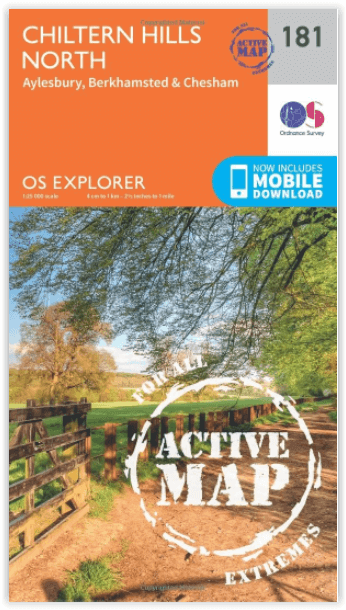
Wandelkaart Chiltern Hills AONB North - Oxfordshire
Omvat ook: Aylesbury, Berkhamsted & Chesham.
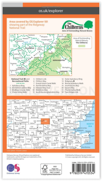
Productbeschrijving: Kaart nummer 181 in de OS Explorer reeks omvat Aylesbury, Wendover, Berkhamstead, Chesham, Princes Risborough en Tring. Hoogtepunten van het gebied zijn The Chiltern Hills, rivier Thame, The Chilterns AONB, Aylesbury Ring, de Ridgeway en de Chiltern way. De OS Explorer kaart voor Chiltern Hills Noord is beschikbaar in zowel de standaard papieren versie als de weerbestendige 'Actief' versie.
Productdiscription: Map sheet number 181 in the OS Explorer series covers Aylesbury, Wendover, Berkhamstead, Chesham, Princes Risborough and Tring. Highlights of the area include: The Chiltern Hills, River Thame, The Chilterns AONB, Chiltern Hills, Aylesbury Ring, the Ridgeway and the Chiltern Way. The OS Explorer map for Chiltern Hills North is available in both the standard paper version and weatherproof 'Active' version.

Locatie op kaart
Gekoppelde artikelen

Wandelkaart 181 Chiltern Hills North AONB- Wycombe - OSI • 9780319243749
standaard versieWandelkaart Chiltern Hills North AONB - Wycombe - OSI Productbeschrijving: Aylesbury- Berkhamsted & Chesham. 181 / Chiltern Hills North, Wycombe, England - Kaart nummer 181 in de OS Explorer reeks omvat Aylesbury, Wendover, Berkhamstead, Chesham, Princes Risborough en Tring. Hoogtepunten van het gebied: The Chiltern Hills, rivier Thames, The Chilterns AONB, Chiltern Hills, Aylesbury R…

Wandelkaart 181 Chiltern Hills AONB North- England - OSI • 9780319470534
weatherproof versieWandelkaart Chiltern Hills AONB North - Oxfordshire Omvat ook: Aylesbury, Berkhamsted & Chesham. Productbeschrijving: Kaart nummer 181 in de OS Explorer reeks omvat Aylesbury, Wendover, Berkhamstead, Chesham, Princes Risborough en Tring. Hoogtepunten van het gebied zijn The Chiltern Hills, rivier Thame, The Chilterns AONB, Aylesbury Ring, de Ridgeway en de Chiltern way. De OS Explorer …
Overzichtskaarten

Area's of Outstanding Natural Beauty - AONB's UK
Area's of Outstanding Natural Beauty - AONB's UK

Producten op de overzichtskaart
Klik op een product om naar de detailpagina te gaan.
- Wandelgids - Guide to the Cotswolds AONB - AA
- Wandelkaart 24 - Chilterns AONB - AA
- Fietskaart- en Mtb kaart - The Cotswolds - Goldeneye
- Wandelgids - Cotswold classic walks guidebook - Goldeneye
- Wandelkaart - Cotswold South AONB - Goldeneye
- Wandelgids - Exploring the Cotswolds - Goldeneye
- Wandelgids - Cotswold Classic Walks - Goldeneye
- Wandelkaart - Cotswolds- Malverns & Forest of Dean - Goldeneye
- Wandelgids - The Cotswold Way 30 classic routes - Cicerone
- Wandelgids - Kent walking guide - Cicerone
- Wandelgids - North Downs Way Nat. trail - Cicerone
- Wandelgids - Chilterns walking guide - Cicerone
- Wandelgids - Suffolk coast & Heaths walks - Cicerone
- Wandelgids - North Downs Way - Map Booklet - Cicerone
- Wandelgids - North Pennines AONB walking guide - Cicerone
- Wandelgids - Ridgeway National Trail - Cicerone
- Wandelgids - Forest of Bowland & Pendle - Cicerone
- Wandelgids - Hampshire's Test Way walking guide - Cicerone
- Wandelgids & Fietsgids - The Cotswold AONB - Cicerone
- Wandelgids - Walking on the Gower - Cicerone
- Wandelgids - North Wessex Downs - Cicerone Press
- Wandelgids - Walking on the North Wessex Downs - Cicerone
- Wandelgids - Silverdale & Arnside AONB - Cicerone
- Wandelgids - The Kennet and Avon Canal walking guide - Cicerone
- Wandelgids - North Downs Way- 246 km - Trailblazer
- Wandelkaart OL2 - Yorkshire Dales- Southern & Western Areas - OSI
- Wandelkaart OL19 - Howgill Fells and Upper Eden Valley - OSI
- Wandelkaart OL21 - South Pennines - Yorkshire - OSI
- Wandelkaart OL31 - North Pennines- Teesdale & Weardale - OSI
- Wandelkaart OL40 - The Broads - OSI
- Wandelkaart OL41 - Forest of Bowland & Ribblesdale - OSI
- Wandelkaart OL45 - The Cotswolds AONB- Gloucestershire - OSI
- Wandelkaart 108 - Lower Tamer Valley & Plymouth- Cornwall- OSI
- Wandelkaart 115 - Exmouth & Sidmouth- Devon - OSI
- Wandelkaart 137 - Ashford- Kent downs AONB- England - OSI
- Wandelkaart 140 - Quantock Hills AONB- Somerset - OSI
- Wandelkaart 140 - Quantock Hills AONB & Bridgwater- Devon - OSI
- Wandelkaart 147 - Sevenoaks & Tonbridge- Kent - OSI
- Wandelkaart 164 - Gower AONB & Gwyr- South Wales - OSI
- Wandelkaart 164 - Gower AONB & Gwyr- Wales - OSI
- Wandelkaart 171 - Chiltern Hills West & Henley-on-Thames OSI
- Wandelkaart 171 - Chiltern Hills West AONB- Wycombe - OSI
- Wandelkaart 172 - Chiltern Hills East AONB- Wycombe - OSI
- Wandelkaart 181 - Chiltern Hills AONB North- England - OSI
- Wandelkaart 181 - Chiltern Hills North AONB- Wycombe - OSI
- Wandelkaart 190 - Malvern Hills & Bredon Hill - OSI
- Wandelkaart 190 - Malvern Hills AONB & Bredon Hill - OSI
- Wandelkaart 203 - Ludlow- Shropshire Hills AONB - OSI
- Wandelkaart 217 - Long Mynd & Wenlock Edge- Schropshire- OSI
- Wandelkaart 254 - Lleyn Peninsular East- North Wales - OSI
- Wandelkaart 261 - Boston- Lincolnshire AONB - OSI
- Wandelkaart 262 - Anglesey West- Wales AONB - OSI
- Wandelkaart 263 - Anglesey East AONB- Wales - OSI
- Wandelkaart 273 - Lincolnshire Wolds South AONB - OSI
- Wandelkaart 282 - Lincolnshire Wolds North AONB - OSI
- Wandelkaart 298 - Nidderdale AONB- Yorkshire - OSI
- Wandelkaart 298 - Nidderdale AONB North Yorkshire - OSI
- Wandelkaart 300 - Howardian Hills AONB - OSI
- Wandelkaart 300 - Howardian Hills AONB & Malton - OSI
- Wandelkaart - Mourne Mountains N. Ireland - Harvey maps
- Wandelkaart - Fietskaart Forest of Bowland - Harvey maps
- Wandelkaart XT40 - Anglesey Coastal Path N. Wales - Harvey Maps
- Wandelkaart XT40 - Pennine Way Noord - Harvey Maps
- Wandelkaart XT40 - Pennine Way Zuid - Harvey Maps
- Wandelgids Cotswold - Way Two-way trekking guide - Knife Edge
- Reisgids Oxford & the Cotswolds AONB - Edicola
- Reisgids Cotswolds England - Rough Guides
- Reisgids Go Slow- Sussex & the South Downs- Weald & Coast - Bradt
- Travelguide Oxford & The Cotswolds pocket guide - Lonely Planet
- Wandelgids - The Ridgeway National trail - Trailblazer
Artikelen uit dezelfde regio

Fietskaart & Mtb kaart The Cotswolds - Goldeneye • 9781859652589
Fietskaart en Mtb kaart - The Cotswolds - Goldeneye Productomschrijving: De Cotswolds is een AONB streek, (Area of Outstanding Natural Beauty) in centraal Engeland. Het gebied omvat de graafschappen Somerset, Warwickshire, Wiltshire, Oxfordshire & Worcestershire, maar het grootste deel ligt in Gloucestershire. Er wordt sinds eeuwen kalksteen uit de steengroeven gewonnen in deze regio, en d…

Wandelkaart 208 Bedford & St Neots Bedforeshire - OSI • 9780319244012
Wandelkaart Bedford & St Neots- Bedforeshire - England Productbeschrijving: Sandy & Biggleswade. 208 / Bedford & St Neots, Bedforeshire, England - OS Explorer kaart 208 toont de steden van Bedford, St Neots, Sandy en Biggleswade. Andere hoogtepunten zijn de Forest van Marston Vale, de Greensand Ridge Walk, John Bunyan proces en de Ouse Valley Way. De OS Explorer kaart voor Bedford & S…

Wandelkaart 153 Bedford- Huntingdon & St-Neots- England - OSI • 9780319262511
Wandelkaart Bedford- Huntingdon & St-Neots - England Productbeschrijving: De oude steden van Bedford, Huntingdon en St Neots liggen allemaal aan de oevers van de Great Ouse - en verschijnen op kaart OS Landranger 153. De belangrijkste bezienswaardigheden van Bedford omvatten St Paul's Church en Bedford Park. Huntingdon, als geboorteplaats van Oliver Cromwell, is een historische stad St Neo…

Wandelkaart 149 Hereford & Leominster England - OSI • 9780319262474
Wandelkaart Hereford & Leominster England Productbeschrijving: OS Landranger kaart 149 helpt u bij het verkennen van de gotische kathedraal van Hereford of een wandeling, of paard rijden rond de omgeving van Herefordshire. U kunt ook de nabijgelegen historische markt steden Leominster, Ledbury en Bromyard verkennen. De OS Landranger kaarten reeks heeft betrekking op Groot-Brittannië met 20…

Wandelkaart 192 Buckingham & Milton Keynes - OSI • 9780319243855
Wandelkaart Buckingham & Milton Keynes - Buckinghamshire Productbeschrijving: Leighton Buzzard & Woburn. 192 / Buckingham & Milton Keynes, Buckinghamshire, England - Kaart nummer 192 in de OS Explorer serie omvat Noord Buckinghamshire en Milton Keynes, met inbegrip van een deel van het bos van Marston Vale. De highlights van het gebied omvatten: Buckingham, Woburn, Leighton Buzzard e…