
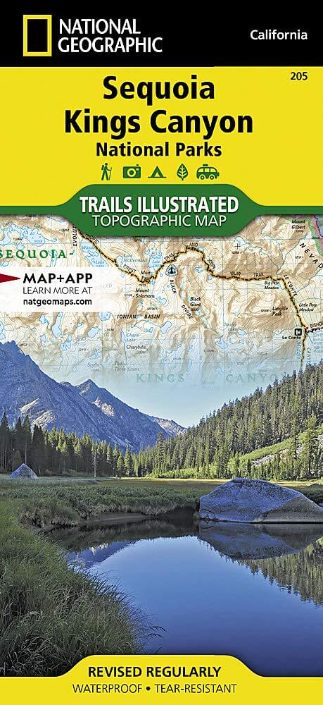
Wandelkaart 205 Sequoia & Kings Canyon NP - California
Gelegen in het zuidelijke deel van de Sierra Nevada
Korte omschrijving
TOPO Wandelkaart 205 - Sequoia & Kings Canyon NP Productomschrijving: Sequoia National Park is een nationaal park in het zuidelijke deel van de Sierra Nevada in Californië. Het park grenst a...

Specificaties
- Uitgever: National Geographic
- ISBN-13: 9781566952989
- HOOFDCATEGORIEËN: Wandelkaart
- Activiteiten: Wandelen, Hiking & Trekking
- Regio: Californië, USA
- Land: Verenigde Staten van Amerika (USA)
- Nationale parken: Sequoia & Kings Canyon NP, California USA
- Schaal: 1:80000
- Afmeting: 10x19
- Taal: Engels
Volledige omschrijving
TOPO Wandelkaart 205 - Sequoia & Kings Canyon NP
Productomschrijving: Sequoia National Park is een nationaal park in het zuidelijke deel van de Sierra Nevada in Californië. Het park grenst aan de noordzijde aan Kings Canyon National Park, en wordt door de National Park Service als geheel beheerd.
Engelse omschrijving: In Sequioa and Kings Canyon National Parks you can walk among the world's largest trees, hike the alpine landscape of the Sierra Crest, and marvel at the towering granite cliffs of one of the deepest canyons in the United States. National Geographic's Trails Illustrated map of Sequoia and Kings Canyon National Parks provides unmatched detail of these parks, meeting the needs of amateur and experienced outdoor enthusiasts alike. Created in partnership with local land management agencies, this expertly researched map features key areas of interest including Sequoia Grove; Giant Sequoia National Monument; John Muir, Golden Trout, Jennie Lakes and Monarch Wilderness Areas; John Muir Trail; Pacific Crest Trail; and Mt. Whitney, the highest peak in the contiguous United States.
With miles of mapped trails in some of the most breathtaking scenery in the entire country, this map can guide you off the beaten path and back again. In addition to detailed and easy-to-read trails, this map includes an accurate road network, campgrounds, scenic overlooks and points of interests, visitor centers and facilities, plus park regulations, backcountry use areas, and contact information for local agencies. The map base includes contour lines and elevations for summits, passes and major lakes. Every Trails Illustrated map is printed on "Backcountry Tough" waterproof, tear-resistant paper. A full UTM grid is printed on the map to aid with GPS navigation.
Other features found on this map include: Cirque Peak, Golden Trout Wilderness, Inyo National Forest, Jennie Lakes Wilderness, John Muir Wilderness, Kings Canyon National Park, Middle Palisade, Monarch Wilderness, Mount Agassiz, Mount Darwin, Mount Goddard, Mount Kaweah, Mount Langley, Mount Muir, Mount Pinchot, Mount Powell, Mount Russell, Mount Sill, Mount Tyndall, Mount Whitney, Mount Williamson, North Palisade, Sequoia National Forest, Sequoia National Park, Sierra National Forest, Sierra Nevada, Split Mountain, Triple Divide Peak.
Locatie op kaart
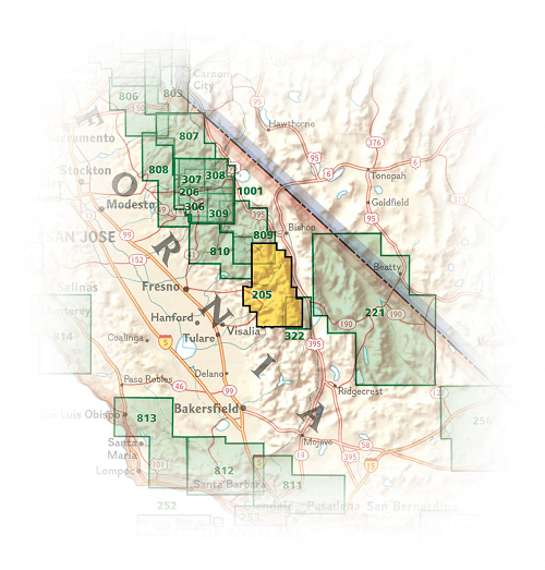
Overzichtskaarten

NAT GEO California trail maps
NAT GEO California trail maps

Producten op de overzichtskaart
Klik op een product om naar de detailpagina te gaan.
- Wandelkaart 205 Sequoia & Kings Canyon NP - California
- Wandelkaart 206 Yosemite NP - California - Nat Geo
- Wandelkaart 218 Redwood National & State Parks - Nat Geo
- Wandelkaart 221 Death Valley NP - Nevada - Natgeo
- Wandelkaart 226 Joshua Tree NP - California - Nat Geo
- Wandelkaart 256 Mojave National park California - Nat Geo
- Wandelkaart 306 Yosemite SW- Yosemite Valley - Nat Geo
- Wandelkaart 307 Yosemite NP North West - Nat Geo
- Wandelkaart 308 Yosemite NE- Tuolumne Meadows - Nat Geo
- Wandelkaart 309 Yosemite SE - Ansel Adams Wilderness - Nat Geo
- Wandelkaart 322 Mount Whitney California - Nat Geo
- Wandelkaart 803 Lake Tahoe Basin - California - Nat Geo
- Wandelkaart 804 Tahoe National Forest West - Nat Geo
- Wandelkaart 805 Tahoe Nat. Forest East - Sierra Buttes - Nat Geo
- Wandelkaart 809 Mammoth Lakes - Mono Divide - Nat Geo
- Wandelkaart 810 Shaver Lake - Sierra National Forest - Nat Geo
Artikelen uit dezelfde regio

Wandelkaart 1008 Pacific Crest Trail - Nat Geo • 9781566957908
Wandelkaart Pacific Crest Trail - Nat Geo Productomschrijving: De Pacific Crest Trail, die in de topografische kaartengids voor de Sierra Nevada North staat aangegeven, loopt door subalpiene bossen en vulkanische rotsformaties en blijft dicht bij de Sierra Crest. De John Muir Trail loopt 160 mijl samen met de PCT en splitst zich in het westen van de PCT bij Tuolumne Meadows in Yosemite Nat…

Wandelkaart 811 Angeles National Forest - Natgeo • 9781566955775
Wandelkaart Angeles National Forest, California USA (9781566955775) National Geographic Productomschrijving: Een bosgebied in de onmiskenbare San Gabriel Mountains in het zuiden van de Amerikaanse staat Californië. Het bestaat uit twee delen die van elkaar gescheiden worden door de Soledad Canyon. Het Angeles National Forest reikt tot net over de grens met San Bernardino County in het oost…

Wandelkaart 322 Mount Whitney California - Nat Geo • 9781566956468
Wandelkaart Mount Whitney California - Nat Geo Productomschrijving: Mount Whitney is universeel bekend als de hoogste piek in de aangrenzende Verenigde Staten, evenals het hoogste punt in Californië. National Geographic's Trails Illustrated kaart van Mount Whitney levert ongeëvenaarde details en waardevolle informatie om je te helpen bij je verkenning van dit prachtige gebied. Deze ka…

Reisgids L'essentiel de Californie - Lonely Planet • 9782816171204
L'essentiel de Californie du Lonely Planet Description de produits: Le guide Lonely Planet qui va à l'essentiel, pour découvrir le meilleur de la Californie. Un guide tout en couleurs, illustré par des centaines de photos. Sonoma Valley, la Pacific Coast Highway, Yosemite, les parcs à thème, San Francisco, Lake Tahoe, Death Valley… tous les incontournables de la région réunis dans ce volum…

Reisgids San Francisco & Northern California - DK Eyewitness • 9780241360071
San Francisco & Northern California Omvat: Presidio, Pacific Heights and the Marina, Fisherman's Wharf and North Beach, Chinatown and Nob Hill, Financial District and Union Square, Civic Center, Haight Ashbury and the Mission, Golden Gate Park and Land's End, and sights beyond the city, plus major parts of Northern California including Carmel, Mendocino, Napa Wine Country, Lake Tahoe & Yos…