
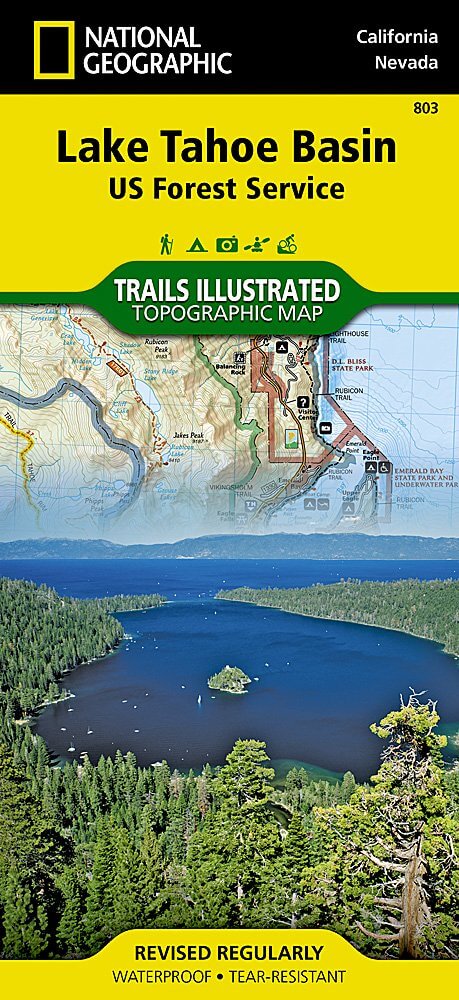
Wandelkaart 803 Lake Tahoe Basin - California - Nat Geo
Lake Tahoe Basin is een bosgebied in het Sierra Nevada-gebergte
Korte omschrijving
TOPO Wandelkaart 803 - Lake Tahoe Basin - California - Nat Geo Productomschrijving: Lake Tahoe Basin is een bosgebied in het Sierra Nevada-gebergte in de Verenigde Staten, dat als National F...

Specificaties
- Uitgever: National Geographic
- ISBN-13: 9781566953344
- HOOFDCATEGORIEËN: Wandelkaart
- Regio: Californië, USA
- Land: Verenigde Staten van Amerika (USA)
- Schaal: 1:63360
- Afmeting: 10x19
- Taal: Engels
Volledige omschrijving
TOPO Wandelkaart 803 - Lake Tahoe Basin - California - Nat Geo
Productomschrijving: Lake Tahoe Basin is een bosgebied in het Sierra Nevada-gebergte in de Verenigde Staten, dat als National Forest. Het bosgebied ligt verspreid over Placer, El Dorado en Alpine County in Californië en Washoe en Douglas County en Carson City in Nevada.
Engelse omschrijving: The largest alpine lake in North America, Lake Tahoe straddles the border of California and Nevada. It's unusually clear waters and surrounding Sierra Nevada mountains make it one of the most beautiful lakes in the world. National Geographic's Trails Illustrated map of Lake Tahoe Basin delivers unmatched detail and valuable information to assist you in enjoying the year-round recreational opportunities this region offers. Expertly researched and created in partnership with local land management agencies, this map includes Desolation Wilderness; Prosser Creek Reservoir; Granite Chief and Mount Rose wilderness areas; and El Dorado, Humboldt-Toiyabe and Tahoe National Forests. In addition, the following state parks are included: Donner Memorial, Ed Z'berg Sugar Pine Point, Emerald Bay, D.L. Bliss, Lake Tahoe Nevada, Burton Creek, and Washoe Lake.
Whether you're exploring Lake Tahoe Basin on foot, or by horse, motorcycle or ATV, the handy trail chart will prove a useful tool in your travels. The popular Pacific Crest and Tahoe Rim trails are clearly noted. A chart of ski and snowboard resorts includes their location on the map, as well as the number of lifts and runs. The map base includes contour lines and elevations for summits, passes and many lakes. The bathymetry of Lake Tahoe is shown with both contours and hill shading. Recreation features are clearly marked, including campgrounds, trailheads, swimming areas, fishing access and scuba diving areas. Every Trails Illustrated map is printed on "Backcountry Tough" waterproof, tear-resistant paper. A full UTM grid is printed on the map to aid with GPS navigation.
Other features found on this map include: Carson Range, Desolation Wilderness, Donner Pass, Eldorado National Forest, Granite Chief Wilderness, Mt. Rose Wilderness, South Lake Tahoe, Tahoe National Forest, Toiyabe National Forest, Truckee, Washoe Lake.
Locatie op kaart
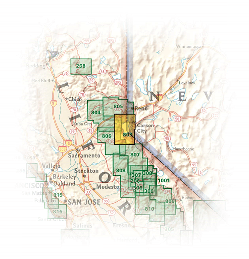
Overzichtskaarten

NAT GEO California trail maps
NAT GEO California trail maps

Producten op de overzichtskaart
Klik op een product om naar de detailpagina te gaan.
- Wandelkaart 205 Sequoia & Kings Canyon NP - California
- Wandelkaart 206 Yosemite NP - California - Nat Geo
- Wandelkaart 218 Redwood National & State Parks - Nat Geo
- Wandelkaart 221 Death Valley NP - Nevada - Natgeo
- Wandelkaart 226 Joshua Tree NP - California - Nat Geo
- Wandelkaart 256 Mojave National park California - Nat Geo
- Wandelkaart 306 Yosemite SW- Yosemite Valley - Nat Geo
- Wandelkaart 307 Yosemite NP North West - Nat Geo
- Wandelkaart 308 Yosemite NE- Tuolumne Meadows - Nat Geo
- Wandelkaart 309 Yosemite SE - Ansel Adams Wilderness - Nat Geo
- Wandelkaart 322 Mount Whitney California - Nat Geo
- Wandelkaart 803 Lake Tahoe Basin - California - Nat Geo
- Wandelkaart 804 Tahoe National Forest West - Nat Geo
- Wandelkaart 805 Tahoe Nat. Forest East - Sierra Buttes - Nat Geo
- Wandelkaart 809 Mammoth Lakes - Mono Divide - Nat Geo
- Wandelkaart 810 Shaver Lake - Sierra National Forest - Nat Geo
Artikelen uit dezelfde regio

Wandelkaart 309 Yosemite SE - Ansel Adams Wilderness - Nat Geo • 9781566954136
Wandelkaart Ansel Adams Wilderness - Nat Geo Productomschrijving: National Geographic's Trails Illustrated kaart van Yosemite SE levert ongeëvenaarde details en waardevolle informatie om u te helpen bij uw verkenning van deze adembenemende wildernis. Deze kaart is gemaakt in samenwerking met lokale landbeheerders en biedt ongeëvenaarde details en nuttige informatie voor zowel ervaren outdo…

Wandelkaart 308 Yosemite NE- Tuolumne Meadows - Nat Geo • 9781566953696
Yosemite North East - Tuolumne Meadows - Nat Geo Productomschrijving: National Geographic's Trails Illustrated kaart van Yosemite NE: Tuolumne Meadows and Hoover Wilderness is ontworpen om te voldoen aan de behoeften van outdoor enthousiastelingen door het combineren van waardevolle informatie met ongeëvenaarde details van deze prachtige regio van het park. Deskundig onderzocht en gemaakt …

Wandelkaart 306 Yosemite SW- Yosemite Valley - Nat Geo • 9781566953627
Yosemite SW- Yosemite Valley & Wawona - Nat Geo Productomschrijving: De Yosemite Valley is een populaire toeristische bestemming, die elk jaar miljoenen bezoekers ontvangt. De gletsjervallei, omlijst door ontzagwekkende granietformaties als El Capitan en Half Dome, staat bekend om zijn dramatische watervallen, reusachtige sequoia's en biologische diversiteit. National Geographic's Trails I…


Wandelkaart 307 Yosemite NP North West - Nat Geo • 9781566954129
Yosemite North West - Nat Geo Omvat: Emigrant Wilderness, Lake Eleanor, Stanislaus National Forest, Yosemite National Park. Engelse omschrijving: National Geographic's Trails Illustrated map of Yosemite North West- Hetch Hetchy Reservoir is designed to meet the needs of outdoor enthusiasts by combining valuable information with unmatched detail of this magnificent region of Yosemite Na…

Wandelkaart 811 Angeles National Forest - Natgeo • 9781566955775
Wandelkaart Angeles National Forest, California USA (9781566955775) National Geographic Productomschrijving: Een bosgebied in de onmiskenbare San Gabriel Mountains in het zuiden van de Amerikaanse staat Californië. Het bestaat uit twee delen die van elkaar gescheiden worden door de Soledad Canyon. Het Angeles National Forest reikt tot net over de grens met San Bernardino County in het oost…