
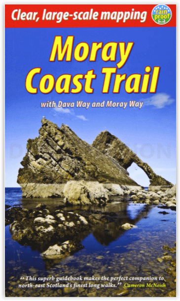
Wandelgids The Moray Coast Trail - Rucksack Readers
Moray Coast Trail > Grantown naar Forres - Dava Way - Moray way
Korte omschrijving
The Moray Coast Trail - with Dava way and Moray way Productomschrijving: Deze nieuwe editie behandelt twee contrasterende routes in detail in het noordoosten van Schotland: De Moray Coast Tr...

Specificaties
- Uitgever: RUCKSACK READERS
- ISBN-13: 9781898481980
- HOOFDCATEGORIEËN: Wandelgids
- Activiteiten: Wandelen, Hiking & Trekking
- Auteur: Sandra Bardwell
- Regio: Highlands, Schotland, Noord Oost Schotland
- Land: Schotland
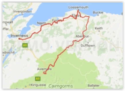
- Lange afstand wandelroutes: The Moray Coast Trail, N.O. Schotland (72 km)
- Blz.: 72
- Schaal: 1:40000
- Afmeting: 13x22
- Editie: 2
- Taal: Engels
Volledige omschrijving
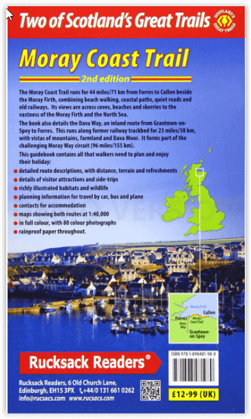
The Moray Coast Trail - with Dava way and Moray way
Productomschrijving: Deze nieuwe editie behandelt twee contrasterende routes in detail in het noordoosten van Schotland: De Moray Coast Trail van Forres naar Cullen, en de Dava Way, een binnenlandse route van Grantown naar Forres. De Moray Coast Trail bestaat uit 44 mijl/71 km strandwandelen, over kustpaden, rustige wegen en oude spoorwegen. Het uitzicht strekt zich uit over inhammen, stranden en scheren tot de uitgestrektheid van de Moray Firth en de Noordzee. De Dava Way strekt zich uit over 23 mijl/38 km landinwaarts met vergezichten over bergen, heidevelden en landbouwgrond. Wij geven ook uitleg over de Moray Way, een route die de meeste van de twee bovengenoemde routes combineert met een deel van de Speyside Way om een 96 mijl lang circuit van aanzienlijke schoonheid en historisch belang te vormen.
Engelse omschrijving: This new edition covers in detail two contrasting routes in north-east Scotland: the Moray Coast Trail from Forres to Cullen, and the Dava Way, an inland route from Grantown to Forres. The Moray Coast Trail consists of 44 miles/71 km of beach walking, on coastal paths, quiet roads and old railways. Its views are across coves, beaches and skerries to the vastness of the Moray Firth and the North Sea. The Dava Way extends for 23 miles/38 km inland with vistas of mountain, moorland and farmland. We also explain the Moray Way, a route that combines most of the above two routes with part of the Speyside Way to form a 96-mile circuit of considerable beauty and historical interest.
The new edition features large-scale mapping (scale 1:40,000), several significant route updates and many fresh photos. We expect to release it in early March, and if you subscribe your email address you will be the first to hear when it’s available. This book is in our pocket-friendly format, with perfect binding instead of concealed wiro. Unlike many paperbacks, it can be opened flat without splitting the spine.
This guidebook contains all you need to plan and enjoy your holiday on and near the Moray Firth:
- detailed description of the Moray Coast Trail from west to east, and Dava Way from south to north
- summaries of distance, terrain and refreshments for each section
- details of visitor attractions and side-trips
- richly illustrated habitats and wildlife
- planning information for travel by car, bus and plane
- contacts for accommodation
- maps showing both routes at 1:40,000
- in full colour, with 80 photographs
- rucksack-friendly and on rainproof paper.
Artikelen uit dezelfde regio

Wandelkaart 391 Ardgour & Strontian Highlands - OSI • 9780319246344
Wandelkaart Ardgour & Strontian - Highlands Schotland Productbeschrijving: Glenfinnan, Loch Eil & Loch Shiel 391 Ardgour / Strontian, Highlands Schotland - Kaart nummer 391 in de OS Explorer kaart reeks is ideaal voor ontdekken van het gebied in de buurt van Ben Nevis. Loch Linnhe, en ligt ten westen van Ben Nevis en Glen Coe met prachtige landschappen en uitdagende wandelingen, die er…

Wandelkaart XT40 Ben Nevis Grampian - Harvey Ultramaps • 9781851375776
Wandelkaart XT40 - Ben Nevis Grampian - Harvey Ultramaps Productomschrijving: Ben Nevis is de hoogste berg van Schotland en ligt in het Grampian Gebergte in het graafschap Inverness aan de ingang van de Glenmore. Het is eveneens de hoogste berg van het volledige Verenigd Koninkrijk. Ben Nevis is 1345 meter hoog en bevindt zich nabij Fort William, ongeveer 160 km ten noorden van Glasgow. He…

Wandelkaart OL55 Loch Laggan & Creag Meagaidh - OSI • 9780319469736
Wandelkaart Loch Laggan & Creag Meagaidh - Highland's Omvat ook: Corrieyairick Pass Productbeschrijving: OS Explorer kaart OL 55 dekt Loch Laggan, onderdeel van het Cairngorms National Park, Corrieyairick forest en 6 Munros. Deze kaart vervangt de vorige OS Explorer kaart 401 voor dit gebied. De OS Explorer kaart voor Loch Laggan & Creag Meagaidh is beschikbaar in zowel de standaard pa…

Mountainbikegids West & Norh West Schotland - Cicerone • 9781852847463
Mountainbikegids - West & Norh West Schotland - Cicerone Productomschrijving: Deze gids beschrijft 25 mountainbike routes in Noord- en Noord West Schotland, een gebied met inbegrip van Fort William, Rannoch Moor, Glen Spean, Invergarry, Loch Sunart, Strathfarrar, Kinlochewe, Sutherland, de Buiten-Hebriden en de bergen van Torridon. De routes variëren van 19,5 km tot 73.25 km, blauw, rood o…

Wandelkaart 409 Raasay Rona & Scalpay Schotland - OSI • 9780319472644
Wandelkaart Raasay- Rona & Scalpay - Highland's Schotland Productbeschrijving: Kaart nummer 409 in de OS Explorer kaart reeks is ideaal voor het verkennen van de Isle of Skye, Raasay, Rona en Scalpay. Hoogtepunten van het gebied zijn onder andere: Dun Caan, Brochel castle, clear Hebridean waters, & The Storr. De OS Explorer kaart voor Raasay, Rona & Scalpay is beschikbaar in zowel de stand…