
Wandelgids Lune Valley & Howgills Lancashire - Cicerone
Gelegen pal tussen 3 natuurgebieden
Korte omschrijving
Wandelgids - Lune Valley & Howgills Lancashire - Cicerone Productomschrijving: Gelegen pal tussen 3 natuurgebieden, en bijgevolg ook de perfecte uitvalsbasis voor wie van de natuur houd. Aan...

Specificaties
- Uitgever: CICERONE Press
- ISBN-13: 9781852849160
- HOOFDCATEGORIEËN: Wandelgids
- Activiteiten: Wandelen, Hiking & Trekking
- Regio: Lanacshire, England, North West England
- Land: England
- Blz.: 208
- Afmeting: 12x17
- Editie: 2
- Taal: Engels
Volledige omschrijving
Wandelgids - Lune Valley & Howgills Lancashire - Cicerone
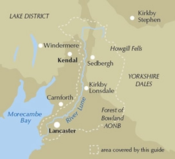
Productomschrijving: Gelegen pal tussen 3 natuurgebieden, en bijgevolg ook de perfecte uitvalsbasis voor wie van de natuur houd. Aan de ene zijde ligt het wereldbekende "Lake District National Park", daar rechts onder het beroemde "Yorkshire Dales National Park", en links onder "The forest of Bowland AONB". Voor wie niet thuis is in het Engelse landschap, AONB's zijn Regio's van uitmuntend natuurschoon, of beter "Area's of Oustanding Natural Beauty. De Lune valley staat bekend voor zijn centraal gelegen uitvalsbasis. duizenden trekken er jaarlijks naartoe, aangezien men van daaruit alle 2 de Nationale parken binnen treedt.
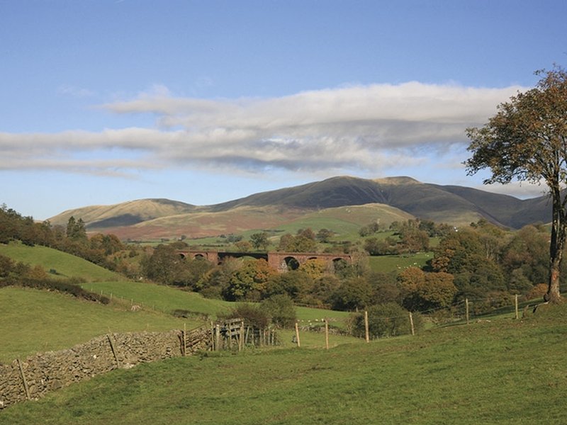
Product description: Guidebook to 40 walks, from 3 to 11 miles, exploring the Lune Valley and Howgill Fells, some of the most unspoilt countryside in north west England. Set mainly within the Yorkshire Dales National Park, and the AONBs of Bowland and Arnside and Silverdale, the walking is hugely rewarding, near the centres of Sedbergh, Kendal and Lancaster.
The Ordnance Survey Explorer maps for the walks in this guide are listed below.
OL19 (Howgill Fells and Upper Eden Valley)
OL7 (The English Lakes, South Eastern area)
OL2 (Yorkshire Dales, Southern and Western areas)
OL41 (Forest of Bowland and Ribblesdale)
296 (Lancaster, Morecambe and Fleetwood
Seasons:
Come spring and early summer, the woodlands, meadows and hedgerows are at their most colourful, and you'll likely get the best weather too. As summer fades, autumnal hues paint another magical time. Crisp winter days can open wonderful distant views, but the weather can sometimes create challenging conditions, even for experienced walkers.
Centres:
Useful facilities exist at the few small towns and larger villages covered by the area, the main centres being Tebay, Sedbergh, Dent, Kirkby Lonsdale and Lancaster.
Difficulty:
The lowland walks are generally without difficulty, but venture onto the higher moors and hills of the Howgill Fells and Bowland fringe, and competent navigation skills and stamina become necessary, particularly in winter. Good footwear, wind and waterproofs underlie basic equipment requirements. Non of the routes demand climbing skills, although some steep gradients may be involved.
Must See:
The Howgill Fells are the main area of high ground covered within the book, the highest point of which is The Calf at 672m. Several of the other summits are also included such as Randygill Top, Green Bell and Docker Knott, with walks routed through the long valleys and along the broad ridges that are such a dominant feature of the area. Other satisfying heights include neighbouring Borrowdale, Middleton Fell and Clougha Pike. Elsewhere, the focus is on the River Lune and its immediate tributaries, exploring its changing character as it winds to the sea.
Locatie op kaart
Artikelen uit dezelfde regio

Wandelgids Lancashire Witch Country - Cicerone • 9781852844462
Wandelgids - Lancashire Witch Country - Cicerone Productomschrijving: De gids van 30 rondwandelingen zijn allemaal ongeveer 6 mijl in lengte, die het wilde en prachtige landschap van Lancashire toont in al zijn glorie. Ze zijn ideaal als halve dag familie wandelingen. Sinds 1612, toen tien Pendle heksen naar het schavot gingen, heeft dit mysterieuze gebied een magische uitstraling doordron…

Reisgids Anwb Extra Liverpool & Manchester • 9789018045807
Reisgids Liverpool & Manchester - Anwb Productomschrijving: Beleef Liverpool met de complete reisgids ANWB Extra Liverpool. De stad is vooral bekend als thuisbasis van de Beatles, maar Liverpool heeft nog veel meer te bieden! De ANWB Extra reisgids Liverpool biedt naast veel praktische tips over hotels en vervoer ook 15 inspirerende bezienswaardigheden die je niet mag missen. Stap in de we…

Wandelkaart 275 Liverpool- South West England - OSI • 9780319244722
Wandelkaart Liverpool - South West England Omvat ook: St Helens, Widnes & Runcorn. Productbeschrijving: OS Explorer kaart 275 omvat Liverpool, St Helens, Widnes Runcorn, alsmede de rivier de Mersey. Hoogtepunten zijn onder andere de Trans Pennine Trail, Mersey way en de Liverpool circelvormige lijn. De OS Explorer kaart voor Liverpool is beschikbaar in zowel de standaard papieren versi…

Wandelgids Cheshire England - historic walks - Cicerone • 9781852843915
Wandelgids Cheshire England - historic walks - Cicerone Productomschrijving: Deze handige gids in zakformaat, bevat routebeschrijvingen voor 20 circulaire dagwandelingen in het historische graafschap Cheshire. Deze schilderachtige wandelingen zijn maximaal 9 km lang en variëren van gracht ballade tot wandeltochten door wilder land. De routes zijn vol van historische bezienswaardigheden en …

Wandelkaart 103 Blackburn Burnley & Clitheroe - OSI • 9780319474266
Wandelkaart Blackburn- Burnley & Clitheroe - OSI Productbeschrijving: Kaart blad nummer 103 in de reeks van de OS Landranger kaarten, is de ideale kaart om te gebruiken bij het plannen van een dag uit rond het noordwesten van Engeland. Onderdeel van de Walliser Way in het oosten van de kaart, samen met de onderste rand van het Yorkshire Dales National Park. Andere plaatsen die zijn opgenom…