
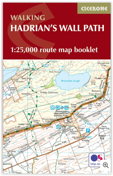
Wandelgids Map Booklet Hadrian's Wall Path - Cicerone
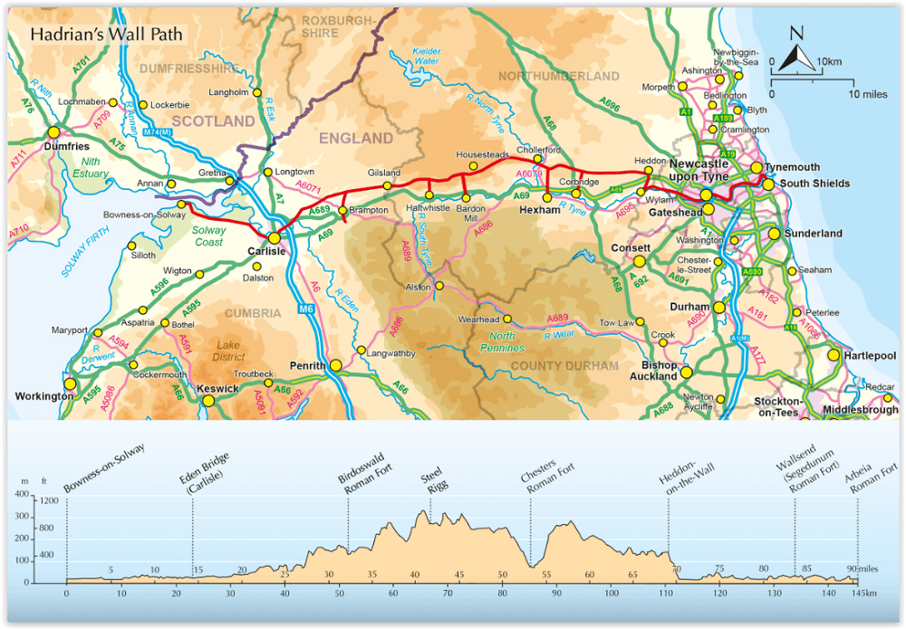
Bowness-on-Solway to Wallsend Newcastle - 135 km
Korte omschrijving
Map Booklet Hadrian's Wall Path - Cicerone Productomschrijving: Boekje van het Hadrian's Wall Path National Trail van 84 mijl (135 km), van Bowness-on-Solway naar Wallsend, Newcastle. Dit bo...

Specificaties
- Uitgever: CICERONE Press
- ISBN-13: 9781786311511
- Activiteiten: Wandelen, Hiking & Trekking
- Auteur: Mark Richards
- Regio: Newcastle, England, Schotse grenzen
- Land: England
- Historische wandelroutes: Hadrian's Wall path (135 km)
- Lange afstand wandelroutes: Hadrian's Wall path (135 km)
- Nationale parken: Northumberland NP, England
- Blz.: 56
- Schaal: 1:25000
- Afmeting: 12x17
- Editie: 2
- Taal: Engels
Volledige omschrijving
Map Booklet Hadrian's Wall Path - Cicerone
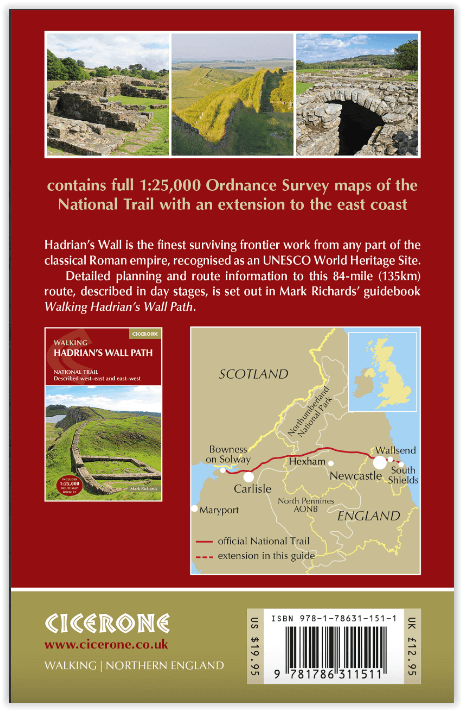
Productomschrijving: Boekje van het Hadrian's Wall Path National Trail van 84 mijl (135 km), van Bowness-on-Solway naar Wallsend, Newcastle. Dit boekje is inbegrepen bij de Cicerone gids voor het pad (9781786311504) en toont de volledige route op OS 1:25.000 kaarten. De route duurt meestal een week en is geschikt voor wandelaars van alle ervaringsniveaus.
Engelse omschrijving: Map of the 84 mile (135km) Hadrian's Wall Path National Trail, from Bowness-on-Solway to Wallsend, Newcastle. This booklet is included with the Cicerone guidebook to the trail (9781786311504), and shows the full route on OS 1:25,000 maps. The trail typically takes a week to walk, and is suitable for walkers at all levels of experience.
Seasons:
Suitable for year-round walking, although better to avoid winter months.
Centres:
Carlisle, Newcastle, Chollerford.
Difficulty:
An interesting and historic national trail suitable for walkers of most abilities. Some short steep ascents.
Must See:
All World Heritage sites including Birdoswald, Housesteads, Chesters Fort, Carlisle Castle, Segedunum Fort.
.png)
Artikelen uit dezelfde regio

Wandelgids Hadrian's Wall Path National Trail - Cicerone • 9781786311504
Hadrian's Wall Path National Trail - Cicerone Productomschrijving: Hadrians Wall Path gids om het 135 km lange National Trail te lopen. Beschreven in beide richtingen, is de hoofdbeschrijving van west naar oost tussen Bowness-on-Solway en Wallsend, Newcastle, met uitbreidingen naar Maryport en South Shields. Met uitgebreide historische informatie over dit Werelderfgoed en een apart boekje …

Wandelkaart 337 Peebles & Interleithen - OSI • 9780319472095
Wandelkaart Peebles & Interleithen - Schotisch borders Omvat ook: Eddleston & Ettrickbridge Traquair & Yarrow. Productbeschrijving: OS Explorer kaart 337 dekt Peebles, Zeist en de omliggende dorpen. Deze kaart toont deel van de "Southern Upland Way" (deel van de E2 Europese Long Distance pad) en de Peebles end van "John Buchan Way", samen met deel van de bovenste Tweeddale nationale Sc…

Wandelkaart 331 Teviotdale South Schotisch Borders - OSI • 9780319245835
Wandelkaart Teviotdale South - Schotisch Borders Omvat ook: Hawick. Productbeschrijving: OS Explorer kaart 331 omvat de rivier Teviot in Teviotdale, de stad van Hawick en de omliggende dorpen. Het terrein is gevarieerd, met zachte valleien oplopend tot enkele steile hellingen en halfhoge pieken. De OS Explorer kaart voor Teviotdale zuiden is beschikbaar in zowel de standaard papieren v…

Wandelkaart 73 Peebles- Galashiels & Selkirk - Schotland - OSI • 9780319473962
Wandelkaart Peebles- Galashiels & Selkirk - Schotish Borders Productbeschrijving: Net ten zuiden van de hoofdstad Edinburgh, toont OS Landranger kaart 73, Peebles, Galashiels, Selkirk alsook Yarrow, Zeist, Stow, Eddleston, Swalmen, Langshaw, Melrose, doven Heights, Glenrath Heights, Gladhouse Reservoir en St. Mary's Loch. De Southern Upland Way (en een deel van het pad van de Long Distance…

Wandelkaart 331 Teviotdale South Scotish Borders - OSI • 9780319472033
Wandelkaart Teviotdale South - Schotish Borders Productbeschrijving: OS Explorer kaart 331 omvat de rivier Teviot, Teviotdale, de stad van Hawick en de omliggende dorpen. Het terrein is gevarieerd, met zachte valleien oplopend tot enkele steile hellingen en half hoge pieken. De OS Explorer kaart voor Teviotdale zuiden is beschikbaar in zowel de standaard papieren versie als de weerbestendi…