
Wandelkaart 1507 Appalachian Trail - Deel 7 - Natgeo
Swatara Gap tot Delaware WG /PA
Korte omschrijving
Wandelkaart 1507 - Appalachian Trail - Deel 7 - Natgeo Productomschrijving: Deel 7 - 3500 km wonderbaarlijke route van Main tot in Atlan. Een uitmuntende langeafstands wandelroutes van zuid ...

Specificaties
- Uitgever: National Geographic
- ISBN-13: 9781597756440
- HOOFDCATEGORIEËN: Wandelkaart
- Regio: Pennsylvania, USA
- Land: Verenigde Staten van Amerika (USA)
- Lange afstand wandelroutes: Appalachian Trail (3500 km)
- Blz.: 40
- Schaal: 1:63360
- Afmeting: 10x19, 11x24
- Taal: Engels
Volledige omschrijving
Wandelkaart 1507 - Appalachian Trail - Deel 7 - Natgeo
Productomschrijving: Deel 7 - 3500 km wonderbaarlijke route van Main tot in Atlan. Een uitmuntende langeafstands wandelroutes van zuid to noord door de Amerikaanse countryside.
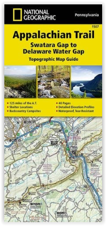
Engelse omschrijving: The Swatara Gap to Delaware Water Gap Topographic Map Guide makes a perfect traveling companion when traversing the northeastern Pennsylvania section of the Appalachian Trail (A.T.). The trail in this section of Pennsylvania primarily travels across flat, rocky ridges mixed with strenuous climbs in and out various gaps. Between Swatara Gap and Wind Gap, the A.T. weaves in and out of Pennsylvania State Game Lands as it follows the long ridge of Blue Mountain. From Wind Gap north, the A.T. follows the ridge of Kittatinny Mountain on its way to the Delaware Water Gap.
Each A.T. Topographic Map Guide includes detailed topographic maps at a detail of 1 inch = 1 mile. Each page is centered on the A.T. and overlaps with the adjacent pages so there is little chance of getting lost. Along the bottom of each page is a trail profile that shows the distance between shelters, camping areas, and trail access points. The map and trail profile provide a step by step visual guide to hiking the trail, mile by rugged mile. The Topographic Map Guide is built for all levels of hiking enthusiasts, from the day tripper to the multi month 'thru-hiker'. The front pages of the printed Topographic Map Guide include resupply information, town inset maps, camping options, and much more.
Every Topographic Map Guide is printed on "Backcountry Tough" waterproof, tear-resistant paper. A full UTM grid is printed on the map to aid with GPS navigation.
Other features found on this map include: 501 Shelter, Allentown Shelter, Bake Oven Knob Shelter, Delaware Water Gap, Eagles Nest Shelter, Eckville Shelter, George W. Outerbridge Shelter, Hamburg, Kirkridge Shelter, Lehigh River, Leroy A. Smith Shelter, Palmerton, Port Clinton, Stroudsburg, Sunfish Pond, Swatara Gap, Swatara State Park, The Pinnacle, William Penn Shelter, Wind Gap, Windsor Furnace Shelter, Worthington State Forest.
.png)
Locatie op kaart
Artikelen uit dezelfde regio

Reisgids Philadelphia - DK Eyewitness • 9780241278666
DK Eyewitness Philadelphia Omvat: the Old City, Society Hill and Penn's Landing, Center City, Logan Square and Parkway Museums District, and sights beyond the city. Productomschrijving: Wandel door het sfeervolle Independence National Historic Park, bewonder beeldhouwwerken in het Rodin Museum of maak een tour langs de slagvelden van de Amerikaanse Burgeroorlog in Gettysburg: alles wat…