
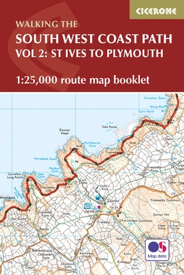
Wandelgids South West Coast Path - Cicerone
Deel 2 betref het zuidelijke deel van St-Ives naar Plymouth
Korte omschrijving
Wandelgids - South West Coast Path - Cicerone Productomschrijving: DEEL 2 - Dit deel betref het zuidelijke deel van de South west Coast path in Devon England - St-Ives to Plymouth Produc...

Specificaties
- Uitgever: CICERONE Press
- ISBN-13: 9781852849375
- HOOFDCATEGORIEËN: Wandelgids
- Activiteiten: Wandelen, Hiking & Trekking
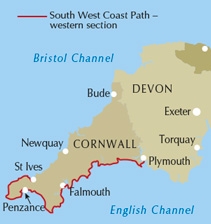
- Regio: South West England
- Land: England
- Blz.: 88
- Schaal: 1:25000
- Afmeting: 12x17
- Editie: 1
- Taal: Engels
Volledige omschrijving
Wandelgids - South West Coast Path - Cicerone
Productomschrijving: DEEL 2 - Dit deel betref het zuidelijke deel van de South west Coast path in Devon England - St-Ives to Plymouth
Product description: The South West Coast Path is Britain's longest National Trail, stretching some 630 miles (1014km) between Minehead in Somerset and Poole in Dorset. It takes in a National Park, 5 Areas of Outstanding Natural Beauty, National Heritage Coasts and a UNESCO World Heritage Site. This booklet of Ordnance Survey 1:25,000 Explorer maps has been designed for convenient use on the trail, covering the southern half of the route between St Ives and Plymouth. It shows the full and up-to-date line of the National Trail, along with the relevant extract from the OS Explorer map legend. It is conveniently sized for slipping into a jacket pocket or top of a ru
Seasons: This National Trail may be walked year-round: be aware that winter accommodation availability may be limited, while high summer will be extremely busy and the weather often hot.Centres:
Many centres are passed along the route, including Penzance, Falmouth, Mevagissey, Polperro, Plymouth.
Difficulty:
The South West Coast path is a long walk! Most paths are easy to moderate, with some walks along rugged and exposed coastal cliff paths and some steep gradients.
Must See:
Areas of Outstanding Natural Beauty, the Jurassic Coast Natural World Heritage Site, numerous Heritage Coasts, National and Local Nature Reserves, Sites of Special Scientific Interest and National Trust holdings.
Locatie op kaart
Gekoppelde artikelen

Wandelgids The South West Coast Path - Cicerone Press • 9781786310682
standaard versieThe South West Coast Path - Cicerone Productomschrijving: Omvat spectaculaire plaatsen die dit deel van het Engelse landschap rijk is, zoals Exmoor National Park, met 5 AONB's of Areas of Outstanding Natural Beauty, de Jurassic Coast Natural World Heritage Site. Deze route bestaat al heel lang. De route start of eindigd natuurlijk in Minehead, in Somerset, loopt langs de kust richting de v…

Wandelgids South West Coast Path North - Cicerone • 9781852849368
standaard versieWandelgids - South West Coast Path North - Cicerone Productomschrijving: Een eerste deel van het 1014km lange wandelpad die in deze gids loopt van Minehead tot St-Yves. Detail Uitgever: The South West Coast Path is Britain's longest National Trail, stretching some 630 miles (1014km) between Minehead in Somerset and Poole in Dorset. It takes in a National Park, 5 Areas of Outstanding Na…

Wandelgids South West Coast Path - Cicerone • 9781786312006
standaard versieMap booklet South West Coast Path - Cicerone Productomschrijving: Kaart van een deel van het zuidelijke deel van het 630 mijl (1014 km) lange South West Coast Path National Trail. Omvat het pad van Plymouth naar Poole langs de kustlijn van Devon en Dorset. Dit handige en compacte boekje met Ordnance Survey 1:25.000 kaarten toont de route en biedt alle kaarten die je nodig hebt om het pad i…
Artikelen uit dezelfde regio

Wandelkaart South West Coast Path 2 - Harvey maps • 9781851374274
Wandelkaart - South West Coast Path 2 - Harvey maps - Covers: The path from Bude to Portreath. Productomschrijving: Waterdichte XT40 kaart van Harvey. Een ideale kaart voor wandelaars op de langste en op één van haar meest populairste nationale routes. Het loopt langs de kust van Somerset, Cornwall en Devon, Dorset van Minehead round via Land's end naar Poole. Het omvat alle 95 mijls …

Wandelkaart South West Coast Path 1 - Harvey maps • 9781851374229
Wandelkaart - South West Coast Path 1 - Harvey maps Productomschrijving: Waterdichte XT40 kaart van Harvey. Een ideale kaart voor wandelaars op de langste en op één van haar meest populairste nationale routes. Het loopt langs de kust van Somerset, Cornwall en Devon, Dorset van Minehead round via Land's end naar Poole. Het omvat alle 95 mijls van het World Heritage site bekend als de Jurass…

Reisgids Go Slow Cotswolds (AONB) - Bradt travel guides • 9781804691717
Reisgids Cotswolds - Bradt Productomschrijving: In deze nieuwe, grondig bijgewerkte 3e editie van Bradt's The Cotswolds, onderdeel van Bradt's kenmerkende 'Slow travel' serie van gidsen over Britse regio's, deelt lokale inwoner en ervaren reisschrijfster Caroline Mills haar favoriete plekken in een regio die onverminderd populair is. Op basis van meer dan 50 jaar wonen in de Cotswolds, en …

Wandelkaart South West Coast Path 5 - Harvey maps • 9781851374427
Wandelkaart - South West Coast Path 5 - Harvey maps Productomschrijving: Waterdichte XT40 kaart van Harvey. Een ideale kaart voor wandelaars op de langste en op één van haar meest populairste nationale routes. Het loopt langs de kust van Somerset, Cornwall en Devon, Dorset van Minehead round via Land's end naar Poole. Het omvat alle 95 mijls van het World Heritage site bekend als de Jurass…

Wandelkaart XT40 South West Coast Path 2 - Harvey maps • 9781851375554
Wandelkaart - South West Coast Path- Deel 2- XT40 - Harvey maps Productomschrijving: Een wandelkaart die het zuidelijk deel beschrijft van het LAW wandelpad in de regio Devon / Cornwall van St-Ives tot Plymouth. De route telt in zijn geheel voor maar liefst 1014km lange wandelpad, genaamd "West Coast Path". De gehele route werd opgesplitst in 3 delen, De ISBN nrs van alle drie de kaarten z…