
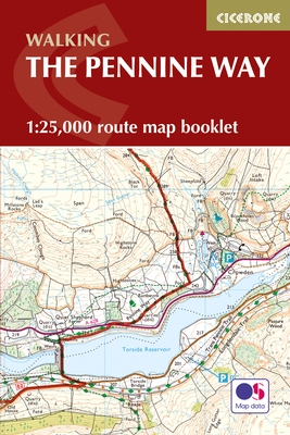
Wandelgids The Pennine Way Map Booklet - Cicerone
De Pennine Way is een lange-afstand wandelpad in Engeland
Korte omschrijving
Wandelgids - The Pennine Way Map Booklet - Cicerone Productomschrijving: De Pennine Way is een lange-afstandwandelpad in Engeland. Het pad meet 463 km, en loopt van Edale in het noorden van ...

Specificaties
- Uitgever: CICERONE Press
- ISBN-13: 9781852849078
- HOOFDCATEGORIEËN: Wandelgids
- Activiteiten: Wandelen, Hiking & Trekking
- Auteur: Paddy Dylan
- Regio: North & North East England
- Land: England
- Lange afstand wandelroutes: Pennine Way (420 km)
- UNESCO werelderfgoed: The Pennine Way through Northumberland NP, North England
- Blz.: 136
- Schaal: 1:25000
- Afmeting: 12x17
- Editie: 1
- Taal: Engels
Volledige omschrijving
Wandelgids - The Pennine Way Map Booklet - Cicerone
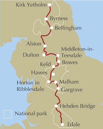
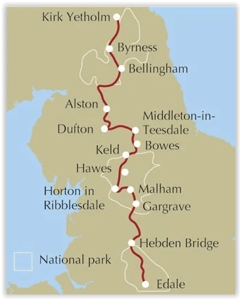
Productomschrijving: De Pennine Way is een lange-afstandwandelpad in Engeland. Het pad meet 463 km, en loopt van Edale in het noorden van het nationaal park Peak District, noordwaarts door de Yorkshire Dales en het Northumberland National Park, om te eindigen in Kirk Yetholm, vlak over de grens met Schotland.
Detail uitgever: Britain's oldest, toughest and best-known long-distance footpath, the Pennine Way stretches 427km (265½ miles) from Edale in Derbyshire to Kirk Yetholm in the Scottish Borders. Showcasing the wild beauty of the North, it crosses three National Parks - the Peak District, Yorkshire Dales and Northumberland National Park – plus the North Pennines Area of Outstanding Natural Beauty and the UNESCO World Heritage Site of Hadrian's Wall.
Seasons:
This National Trail is essentially a summer walk, though it can be completed in spring or autumn, the winter months are solely for dedicated and experienced long-distance walkers.
Centres:
Edale, Crowden, Hebden Bridge, Cowling, Gargrave, Malham, Horton in Ribblesdale, Hawes, Keld, Bowes, Middleton-in-Teesdale, Dufton, Alston, Hadrian's Wall, Bellingham, Byrness, Kirk Yetholm.
Difficulty:
The Pennine Way is a challenging walk, often across high, exposed moorlands. No problems on fine, sunny days, but some parts can be exceptionally difficult in bad weather. In mist, careful navigation is required, but on the whole the route is well-signposted. Suitable for backpackers and youth hostellers, but ample B&B accommodation is also available. Previous long-distance walking experience is an advantage.
Must See:
Peak District National Park - Kinder Scout, Bleaklow and Black Hill; South Pennines - Stoodley Pike and Brontë Country; Yorkshire Dales National Park - Malham Cove, Pen-y-Ghent and Great Shunner Fell; North Pennines AONB - Teesdale, High Cup and Cross Fell; Northumberland National Park - Hadrian's Wall and the Cheviot Hills.
Locatie op kaart
Overzichtskaarten

Artikelen met UNESCO Werelderfgoed locaties
Artikelen met UNESCO Werelderfgoed locaties

Producten op de overzichtskaart
Klik op een product om naar de detailpagina te gaan.
- Wandelkaart 10047 - Aurland- Sogn og Fjordane - Nordeca AS
- Fietsgids - A vélo en Ardèche méridionale - 46 balades - Glénat
- Wandelgids Rheinsteig - Rheinburgenweg & höhenwegen - Rother
- Wandelgids Pfälzer Weitwanderwege & Weinsteig - Rother
- Wandelkaart XT25 - Yorkshire Dales Zuid-Oost - Harvey maps
- Wandelkaart XT40 - N.O. Yorkshire Dales NP - Harvey ultramaps
- Wandelkaart XT40 - N.W. Yorkshire Dales NP - Harvey Ultramaps
- Wandelkaart XT40 - Z.O. Yorkshire Dales England - Harvey Maps
- Wandelkaart XT40 - Z.W. Yorkshire Dales - Harvey Ultramaps
- Wandelkaart 3713 ET - Pays de Bitche & PNR des Vosges du Nord
- Fietsgids - Canal du Midi cycling - Cicerone
- Wandelgids Japan's Kumano Kodo Pelgrimage - Cicerone
- Wandelgids - The Pennine Way Map Booklet - Cicerone
- Fietsgids Bedevaart Ruta Via de la Plata cycle route - Cicerone
- Wandelgids - Italy's Cinque Terre walking - Cicerone
- Reisgids Chaîne des Puys- Auvergne France - Ed. Ouest-France
- Guide de voyage - Angkor en quelques jours - Lonely Planet
- Guide de voyage - Angkor en quelques jours - Lonely Planet
- Le Canal du midi à vélo - Editions Ouest-France
- Wandelkaart 229 - Salzkammergut - Kompass
- Wandelkaart 204 Truro & Falmouth- Cornwall England - OSI
- Wandelkaart 005 - Mont Perdu & Gavarnie - Sua Editions
- Wandelkaart 0/16 - Mount Kenya Nationalpark - Alpenverrein
- Travelguide - Angkor Wat & Siem Reap pocket guide - Lonely Planet
- Wandelgids Tour of the Jungfrau - Cicerone
- Wandelkaart Geopark Harz - Braunschweiger Land - Huber
- Wandelkaart XT25 - Yorkshire Dales NP Noord-Oost - Harvey maps
- Wandelkaart - South West Coast Path 5 - Harvey maps
- Wandelgids - Wanderführer Dolomiten 1 - Hikeline
- Wandelgids - Wanderführer Dolomiten 2 - Hikeline
- Wandelgids - Ostfriesland Duitsland - Rother
- Wandelgids - Pfälzerwald & Deutsche Weinstrasse - Rother
- Wandelgids Drakensberg - 75 day walks - Cicerone
- Fietskaart & wandelkaart 368 - Rhein Radweg 3 - Publipress
- Wandelgids & klimgids - Berner Alpen 4- Jungfrau Region - SAC
- Wandelgids - Hadrian's Wall Path - Rucksack readres
- Wandelkaart - Hadrian's Wall Path - Harvey maps
- Wandelkaart - South West Coast Path 1 - Harvey maps
- Wandelkaart - South West Coast Path 3 - Harvey maps
- Wandelkaart - South West Coast Path 4 - Harvey maps
- Wandelkaart - South West Coast Path 6 - Harvey maps
- Wandelkaart XT25 - Yorkshire Dales Zuid-West - Harvey Maps
- Wandelkaart 194 - Dorchester & Weymouth- Dorset - OSI
- Wandelkaart 179 - Canterbury- East Kent - England - OSI
- Wandelkaart 195 - Bournemouth & Purbeck- SW England - OSI
- Wandelkaart 193 - Taunton & Lyme Regis- Somerset - OSI
- Wandelkaart 2241 SB - Albi & Cordes-sur-Ciel - IGN
- Wandelkaart 179 - Canterbury & East Kent - England - OSI
- Wandelkaart 247t - Sardona Graubünden - Swisstopo
- Fietsgids Bikeline - Neusiedler See - Radweg - Estenbauer
- Wandelkaart 2136 ET - Rocamadour & Padirac - IGN
- Wandelgids - Massif Central (week-end) à pied - Ed. Chamina
- Wandelkaart 2137 SB - Gramat & Rocamadour - IGN
- Compostelle en France nouveaux chemins- Ed.Ouest France
- Wandelkaart 2138 OT - Cahors & St-Cirq-Lapopie - IGN
Artikelen uit dezelfde regio

Wandelgids The Dales Way 135 km - Cicerone • 9781786310934
The Dales Way 135 km - Cicerone Productomschrijving: Gids voor het afleggen van de Dales Way. Deze schilderachtige route van 79 mijl (135 km) door de Yorkshire Dales tussen Ilkley en Bowness-on-Windermere, en is een van de rustigste lange-afstandswandelingen in Groot-Brittannië. De route wordt in beide richtingen beschreven en gaat door Wharfedale, Dentdale en de oostelijke rand van het La…

Wandelgids Teesdale Way - Cicerone • 9781852844615
Wandelgids - Teesdale Way - Cicerone Productomschrijving: Deze handige gids is ideaal voor degenen die van plan zijn om de 135 km lange Teesdale Way te doorlopen. De route wordt beschreven in acht stappen en heeft betrekking op de gehele 100 mijl van Dufton naar Teesmouth. Elke fase biedt gematigde dagwandelingen en gemakkelijk 2 weken. Het omvat ook routebeschrijvingen voor een selectie …

Wandelgids Cleveland Way Map Booklet - Cicerone • 9781852849344
Wandelgids - Cleveland Way Map Booklet - Cicerone Productomschrijving: Boekje van de kaart van de Cleveland Way National Trail, een 177km (110 mijl) lopen rond de North York Moors National Park. Dit boekje wordt geleverd met de Cicerone gids naar de Cleveland Way en de Yorkshire Wolds Way en toont het volledige parcours van de Cleveland Way op kaarten van Ordnance Survey 1: 25.000 Prod…

Wandelgids Dales Country Yorkshire England - Cicerone • 9781852843236
Wandelgids - Dales Country Yorkshire England - Cicerone Productomschrijving: Een gids over 30 familiewandelingen in de Yorkshire Dales, Engeland. De 30 circulaire wandelingen nemen de bekende Dales plekken in zoals Malham en Ingleborough. Routes nemen tussen een halve tot een volledige dag in beslag. Ook minder bezochte, bijna geheime routes, ingedeeld van gemakkelijk tot inspannend. P…

Wandelgids Dales Way-Map Booklet - Cicerone • 9781786310941
Map Booklet - The Dales Way - Cicerone Press Productomschrijving: OPGELET: inbegrepen indien u de wandelgids zelf koopt. Kaart van de 79 mijl (135 km) lange Dales Way door de Yorkshire Dales tussen Ilkley en Bowness-on-Windermere. Dit boekje is bijgesloten bij de Cicerone gids en toont de volledige route op OS 1:25,000 kaarten. Het is een van de meest rustige meerdaagse wandelingen in Gro…